Leaderboard

.thumb.jpg.07ee12b2da3df67be485333447c664f3.jpg)

Popular Content
Showing content with the highest reputation on 03/08/2021 in all areas
-
That old road is on the storage place's land. THEY don't have a problem with mountain bikers using their land. But, the theory is, one of those landowners to the south of that land DOES have a problem with it. Maybe it's because trash from parties washes down into their ponds. A guy that lives one parcel over, to the south, doesn't know who it is. HE likes the mountain bikers. He actually mows the 1826 single track because he likes to see us ride past. But there won't be any more discussions with the storage place folks. I'm sure they will eventually decide that it's not worth a feud with their neighbors over it and just tell us to stop. But I've given up on using it anyway. I now go past the storage place going up Slaughter Lane and turn left past the water tank. A little more climb but also a little more down hill zooming once on the 1826 single track.3 points
-
Rode all of DD and 1/4 Sat and everything was clear except for some remaining carnage on Dare and on Huck Finn. I went back out today and took care of both of those spots, and also cleared a bunch of low-hanging stuff throughout DD. Great weekend to be back out riding!3 points
-
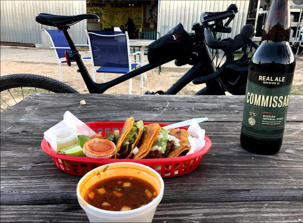
Sabor Tapatio's Tacos de Birrira (properly termed, I think, Quesabirria Tacos) are glorious. Crunchy. cheesy and savory. Served with consume, you dip the tacos right in to make them even better. I think they are what you've been missing out of your life. And while they are a food truck, and don't have alcohol, they are right next to a Twin Liquors. That's where I scored this excellent Russian Imperial Stout. Just don't go on a Sunday.
 3 points
 -
It is slower to open than other local trails. You can check if the mountain bike trails are open on their website: https://parks.traviscountytx.gov/parks/reimers-ranch?fbclid=IwAR3IEGoMIZg10S9AzIgezCUrA2pVkqsIhzS9ZFJgGm_706HQHVRzcQ8752A The 411 on Reimers: -30 minute drive from The Y in Oakhill -$5 per person to get in -Approximately 18 miles of single track AND 18 miles of scenic double track. All of it has very good trail signage now. -The single track looks confusing on Strava, but it is very easy to see how the trail system was laid out once you start to use it. Very hard to get lost, just keep on going. There are very well labeled green, blue, and black trails. Don't be scared of the black trails. There might be a few challenging features here and there but 90% of both black segments can be ridden by just about any rider. It's possible to ride all of the 18 miles of single track in one long segment without repeating much. -Very scenic. Lots of photo opportunities out on the trail. -All the single track is one direction. Never worry about head-ons there. -The Flow Trails Area features big machine built features utilizing 140 feet of drop. Very different from anything else in the area. Take Milton's Shortcut from the bottom to do multiple runs. Most of the features have at least two lines to them, some have three. You don't have to leave the ground to enjoy this trail. Do it multiple ways. Fast on the ground, or taking air at every chance. -Practice your jumps on the "13 Jumps" jump line. It is four groups of 4 or 3 small jumps to get anyone comfortable in the air. It is on the "Fenceline" segment. The jump line is mere feet to the right of the established trail tread. -Swim in the Perdernales River after your ride. -Hike Climber's Canyon to see a Jurrasic Park type environment. Ferns and springs. Very interesting. -Ride out from the single track area to find one of the two Pogue Spring Canyon overlooks. It's not the Grand Canyon, but it is impressive for being "right there." Bonus jumps: there are three big water bars (humps in the road) on the jeep road just east of Fenceline that are fun hitting at speed.2 points
-
or "dippin' sauce" for us less cultured.2 points
-
Sweet jump!1 point
-
Yes, it's on that trail, "Fenceline." But the actual "13 Jumps" segment is all between your bottom arrow (the highest point on the trail) and the "m" on "Intermediate Trail." The blue line that goes between the "e" and the "r" of Intermediate is Two Cones Road, a jeep track. After the last jump (actually the one I'm going off in the picture) you can turn left to ride the jeep road for 75 yards and then turn left to go up that black line pictured. That is Cardosa's Climb. I don't know why it is black, it actually is a very easy blue, and blue only because of the climb involved. Turn left on the not pictured short cut back to Fenceline to repeat the jump line. Edited to say, a picture is worth a thousand words: https://www.strava.com/segments/274428201 point
-
Me enjoying one of the new jumps on "13 Jumps" jump line at Reimers.1 point
-
I love these Sur Ron Bikes, I just wish they would make one with a legit larger frame. Sure you can get a riser setup and a seat elevation kit, but then it looks stupid AF. They need to offer a frame version that legit fits a 6' tall guy. I would own one for sure if so. Would be helpful at the ranch.1 point
-
it would be helpful if someone, either the aggrieved neighbors or the riders, would block that route from the Slaughter Lane end as well. it's very confusing to enter that side and reach 1826 only to find a wall you didn't expect.1 point
-
Uhhh... what just happened? lol1 point
-
OMG, that looks awesome! Need to hit that. In some parts of Mexico they call those tacos ahogados (drowned tacos). Spanish pedant nit-pick alert: I'm sure auto-correct had something to do with it, but it's consomé, just like in French. 🙂1 point
-
This is the kind of electric bike I don't want on our trails. But I really want to own one.1 point
-
Keep in mind this was always private property and what remains still is. Nothing good will come of promoting private property on a public forum (or with strava, etc).1 point
-
I recommend: NOT taking bikes = no worries about theft and the constant hassle of bike wrangling when they aren't in use. If you are in a mtn biking destination area, there will be quality bikes for rent. E-bikes and cruisers will be available for rent in more developed areas and you can cruise around as a fam. Just pack a bag with shoes, helmet and gloves and you're set. Thread drift: Rainbow Rim Trail shout out! Note: Spring Break is too early in the year (cold, snow) for the Kaibab Plateau, North Rim. But still, because there are vacations to come and this can be done in summer. The trail outside the national park on the north rim of the Grand Canyon is the Rainbow Rim Trail. We were there maybe 12 years ago and I loved it. More miles have been added for a total of 22 miles one way. It's a very, very long slog to get to the North Rim area and requires being self contained, although the National Park North Rim is relatively close by and has some services. It's not an overly technical trail, but it's a trail at 7,700' on the west edge of the Kaibab Plateau and there's close to 1,800' of cumulative climbing. It's character is that it contours the rim, so you ride out onto one of five points with spectacular views of the Canyon, then ride back into the Ponderosa pines and contour around a drainage, then back out onto the next point with some pinyons, sage and more gobsmacking views. This Trail Forks page shows clearly how the trail is laid out: Rainbow Rim Trail. They rate the trail as Intermediate in difficulty, with a physical rating of Moderate. We camped roughly in the middle, and did an out and back to each end; it was 18 miles end to end at that point and I don't recall that out & back for each segment was that stressful. Although this isn't wilderness and is carved up by numerous logging roads, I've never been in a place in the lower 48 that felt so "out there" remote and I don't know why exactly. We were getting close to camp finishing up the second segment at dusk. Mr. June Bug was riding slightly ahead of me and I got major "I'm being followed by a mountain lion" paranoia. No sighting, but again, just that kind of place. Camping was dispersed -- you just found your spot and set up anywhere, nothing developed, no services. Things have likely gotten more formal in the intervening years since what amazing place hasn't been discovered, trashed, and formalized w/ rules and regs. I very much want to go back. We may do this as a tour with Western Spirit this summer and let them handle logistics. Their four or so photos show a good sampler. The Arizona trail is close by, goes all the way from the North Rim to the Utah border, so that's another riding option. For example, AZ Trail, Passage 40, South Kaibab I hope I've convinced someone to go this summer. You get the Grand Canyon experience without the crowds and can ride a lovely trail that won't beat you up!1 point
-
Cool to see this perspective of a pro racer. Not a rock in sight🤣1 point