June Bug
-
Posts
1,029 -
Joined
-
Last visited
-
Days Won
31
Content Type
Profiles
Forums
Gallery
Calendar
Everything posted by June Bug
-
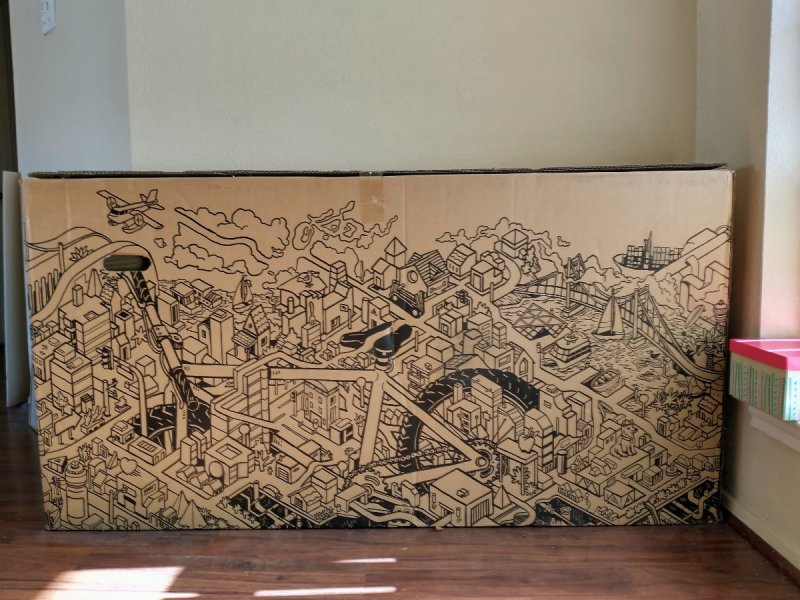
This (empty!) bike box has been sitting in my foyer for a year. The designers created something that kids (or adults) might like to color. If you have a houseful of younger kids and it's too cold for them to go outside -- nice project. Alternately, use it for its intended purpose. Otherwise it will be recycled in about two weeks (our next recycling day). In north Austin close to Walnut Creek Park. Respond below if you're interested and I'll message you the address. This is one side, there's an equally detailed but different design on the other side.
-
Some of y'all may have caught this story on the news over the last few days -- a young couple driving on the Angeles Crest Highway lost control of their car after pulling over to let an aggressive driver pass, and went tumbling down end over end 200 (some reports) to 300 (other reports) feet along a cliff to the bottom of a canyon. Zero cell service in that area. None of the media reports indicate that anyone witnessed the car going over the edge. The couple had no cell service but were rescued after their iPhone detected the fall. Amazingly, the couple only had scrapes and bruises and were able to crawl out of the car, which had landed upside down, so Miracle #1. Miracle #2 -- They were able to find the woman's cell phone about 10 yards from where the car landed, and a message had popped up on the phone, saying a crash had been detected and to swipe to contact emergency services. "...The message that appeared on the iPhone was part of Apple's new Emergency SOS via satellite feature, which has Crash Detection and Fall Detection software and uses satellites to contact emergency services when an iPhone is out of range. The feature connects the iPhone user to an emergency call center, which can collect information and notify rescue services...The message that appeared on the iPhone was part of Apple's new Emergency SOS via satellite feature, which has Crash Detection and Fall Detection software and uses satellites to contact emergency services when an iPhone is out of range. The feature connects the iPhone user to an emergency call center, which can collect information and notify rescue services." These two were rescued within 30 minutes because they could text with emergency services and rescuers were able to pinpoint their exact location. "The feature, which Fields did not even know was on the iPhone she had only recently gotten, launched in mid-November. It's currently on iPhone 14 and iPhone 14 Pro devices running iOS 16.1 or later…Emergency SOS via satellite also allows users to share their location with friends and family if they'd like to check in while traveling off the grid. It's also free for two years after an iPhone 14 is first activated, according to Apple."
-
Wonderful news, BUT a 10-ft-width just doesn't cut it for the amount of traffic these types of trails receive these days. For example, the 10-ft-width on the Southern Walnut Creek Multi-Use Path, heavily used by cyclists, is woefully inadequate. Considering the amount of lead time that goes into funding, planning/design, opening the project for bid and awarding the contract, little chance for input even for future projects. Don't get me wrong -- these paths are of huge benefit to those that use them, just wish they were a bit wider.
-
Yup, from the Austin Ridge Riders facebook page: With regret, we are rescheduling Cranksgiving to January 21, 2023. Due to the recent rain and the forecasted heavy rain for the rest of this week, the bike trails at Reimers Ranch Park are closed now and are expected to remain closed through the weekend. We felt it was better to call it sooner than later so those who were planning on attending can plan to do something else.
-
Cancelled: ARR's Cranksgiving SATURDAY, JANUARY 15
June Bug replied to June Bug's topic in Mountain Biking Discussion
This just popped up on facebook: Cranksgiving 2022 has been cancelled and rescheduled for January 21, 2023. -
The Second Sign of the Apocalypse
June Bug replied to AustinBike's topic in Mountain Biking Discussion
Forest Service and BLM have always flailed a bit where user policy is concerned, and not just related to mountain bikes, although sometimes they get it just right. Where BLM got it wrong: There's a new trail system near Mancos (about 9 miles from Dolores) called Aqueduct on a bit of BLM land, signed for mountain bikes and equestrians only. It's a well designed and purpose built trail...for bikes...but terrible for horses. A section goes into a long flow trail in an arroyo that's unrideable for equestrians. I really don't get it. It's built on the Mancos Shale formation and one or two equestrians riding on parts of the trail while it's still on the wet side would destroy it. Chicken Creek trail system (Forest Service), very close to Mancos, has maybe 20 or 30 miles of buff singletrack and two-track winding through the Ponderosas, perfectly suited to equestrians and I'm pretty sure it allows horses. A few miles further along towards Dolores? 3,000 acres of BLM land that strictly prohibits mountain bikes. Equestrians and hikers only, no defined trails. Until this past year, when a survey issue was resolved, this BLM land could not be accessed by the public. This allows public use, without much oversight on BLM's part, so equestrians, go for it! I mention these as instances as a microcosm of weird policy by Federal agencies. The Forest Service has it right on Boggy Draw and Chicken Creek, though. In winter, Boggy Draw trails are groomed for fat biking and Chicken Creek is groomed for cross country skiers. Anyway, e-bikes. I'm starting to realize that possibly the fastest segment of e-bike adopters are older cyclist, both mountain bikers and roadies. Oh, and gravel. Don't forget gravel. Also, as all-electric and hybrid cars are becoming more popular and accepted, battery technology will grow at an accelerated pace and that tech will be reflected in e-bike technology. -
The Second Sign of the Apocalypse
June Bug replied to AustinBike's topic in Mountain Biking Discussion
Forest Service. That entire trail system is actively maintained with weekly work days throughout the summer; maybe somebody brought the sign over from the trail head. I noted a few e-bikers ignoring the the ban on e-bikes in that trail system. -
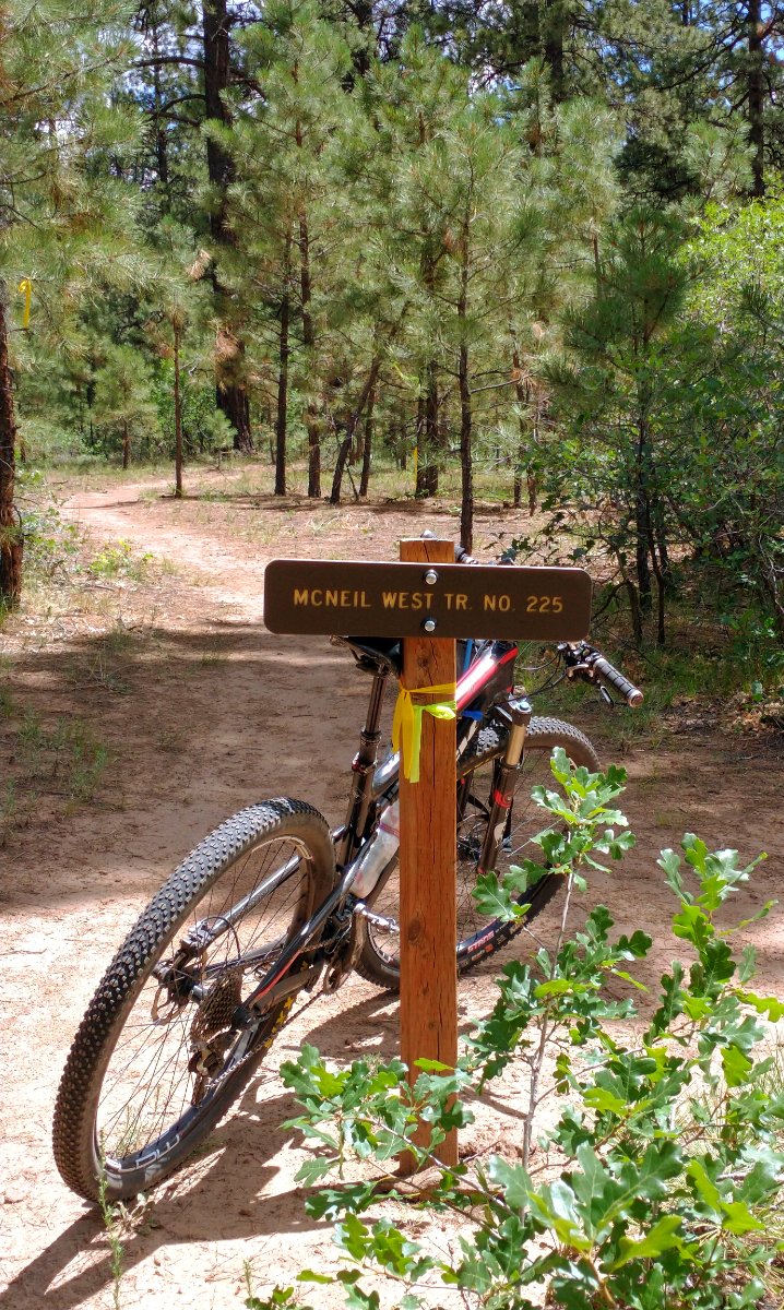
Boggy Draw Trail, (mtbproject page for Boggy Draw) extensive system of mostly buff single track though the Ponderosa pine forest:

-
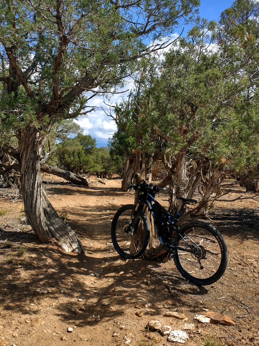
Hippie House Trail at Phil's World:

-
The Second Sign of the Apocalypse
June Bug replied to AustinBike's topic in Mountain Biking Discussion
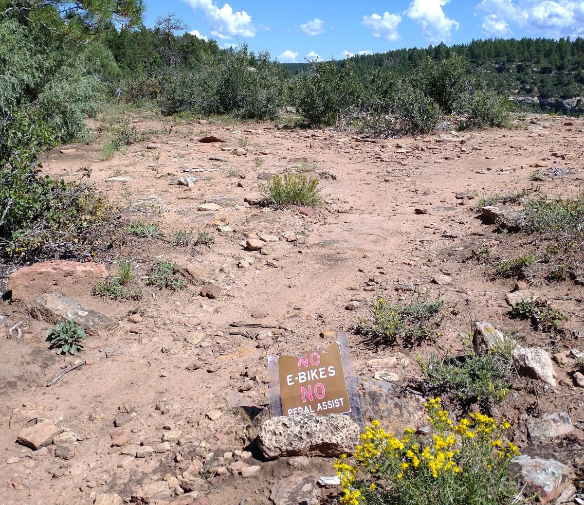
No idea how this little sign ended up about five miles from the trailhead at Boggy Draw Trail System in SW Colorado, but there it was.
-
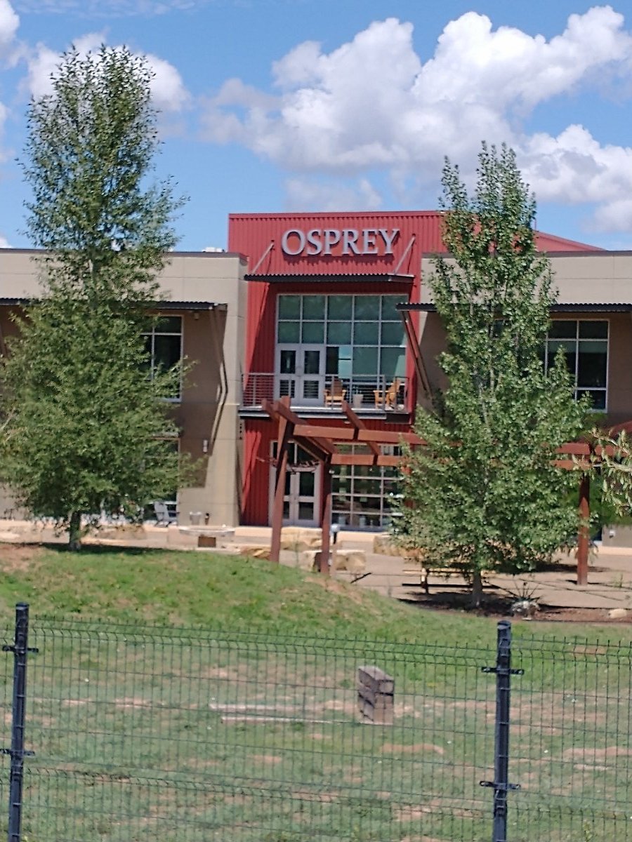
Osprey is honoring their Almighty Guarantee and a new Raptor 14 will be on the way soon. The old one wasn't repairable. Mr. June Bug will be using it; he opted for basic Black.
-
Dropper seat post is that first cousin who always has your back.
-
My attempt at a "Cheap" Cycle Computer
June Bug replied to RedRider3141's topic in Mountain Biking Discussion
Correct. Retired my 3G IPhone because it was no longer supported -- that was a year or two ago. -
My attempt at a "Cheap" Cycle Computer
June Bug replied to RedRider3141's topic in Mountain Biking Discussion
Dang! Earlier this summer I recycled all of my old cell phones! But how do you use the phone and load apps without an active cell phone plan? Also, Ride With GPS has specific instructions on what to turn off to use voice prompts only to save battery life. We used it a few weeks ago in SE Utah (zero cell service) and it worked great. -
Good reminder! Bar soap. Just had a flashback. Back when I did a lot of sewing, one could run the end of a thread though some beeswax or bar soap to help thread it through a needle. It's also used as a thread conditioner.
-
To further the zipper lube discussion, and I know this is just crazy talk, but you can buy actual zipper lube: Gear Aid Zipper Cleaner + Lubricant (Amazon link). REI also has it HERE. It has a little brush applicator right on the bottle! A little goes a very long way.
-
May have posted this in another thread, but a good reminder that Osprey's Almighty Guarantee really is what they say it is. Scored a Raptor at an RLAG gear exchange this spring. The shoulder straps and waist belt were worn out, but the rest of the pack is in very good shape. In Sept., used Osprey's Customer Support Page to set up a repair order, got my repair reference number, dropped it off at headquarters (Osprey headquarters is <15 minute bike ride from my current address for two more weeks). Should have a like-new pack with new shoulder straps and waist belt in January or so (the turn around time for big repairs is about three months) mailed to my Austin address.

-
I went to the library and got to the point where I had to get an admin log on and password to complete the download to update the InReach firmware and I knew that wasn't going to happen. We took the InReach with us on our ride today - the SOS function will work in dire circumstances, so I'll just let that be what it is. Garmin InReach pairs with Earthmate, but I'll save all of that to when we get back to Austin. Yesterday I bought Ride With GPS Basic and it may be the best money I've ever spent. Setting up the route for today's ride was, literally, effortless and Ride With GPS will work without internet or cell service. The web site has a list of all the things to do to extend battery life in that mode. Even with the screen off, it gave voice prompts, so we easily navigated from Hovenweep National Monument to Hatch Trading Post via Black Steer Canyon. We got to Hatch Trading Post in record time (all hard packed dirt and gravel after the first mile) because there's a cumulative loss of just under 800' over 11 miles, mostly from dropping down off Cajon Mesa into Black Steer Canyon; lots of rolling terrain as well. It was brutal on the return with a headwind of 15 to 20 mph and some steep pitches to get back up to the top of Cajon Mesa. Amazing country out there. This was a useful recon to see if it was feasible to bike ride the 43 miles down Montezuma Canyon Rd (gravel) to Hatch Trading Post with an overnight camping, then head east to Hovenweep National Monument on Black Steer Canyon Rd. (Hovenweep would be a safe place to leave a car) As it turns out, we rode about a mile up Montezuma Canyon Rd from Hatch Trading Post and it was total washboard misery, so unless San Juan County, Utah decides to maintain and blade Montezuma Canyon Rd, we'll put this on the back burner. Click here for some info on the amazing Montezuma Canyon.
-
I checked in with the local LBS and they suggested a phone repair place that also does a little bit of computer stuff, but that doesn't seem like quite the right avenue. I'll head to the library today. Since I have a local address, they gave me a free library card. I use them when I need to print something and to check out Tony Hillerman and Anne Hillerman murder mysteries. Like all librarians they are very helpful, but I don't know how tech savvy they are or if they have one tech savvy person on staff. The computers do have Firefox for the default browser; not sure if they are Windows based. Sadly, they don't have MAC laptops for checkout. I want to do a ride in a few days from Hovenweep National Monument on the Colorado/Utah border, over to Hatch Trading Post (now abandoned) via unpaved Black Steer Canyon Rd. This is a recon of sorts for a longer ride I want to do. This is not wilderness by any means but it's way the heck out there with very little traffic and zero cell service -- an empty quarter of sorts. We're old people on our own (74 and 77) and I don't want to be out there without an InReach or some way to get help if anything should happen.
-
We're in SW Colorado for another month to six weeks and I got the InReach personal locator beacon out to update the firmware and pair with my cell phone for emergency messaging since we'd like to do a little bikepacking. It's an older InReach, bought just as Garmin bought out DeLorme. Then I remembered I ran into this problem awhile back. Garmin firmware updater and other support works only with Windows and MAC; Garmin still can't be bothered to support Chrome or Linux. We have two Chromebooks and no Windows or MAC here. Mr. June Bug has a new to him Chumba Stella and it came with lots of bike packing gear and an unused (still in the package) SPOT. As it turns out, the SPOT firmware update (the most recent is 2/7/2022) also works only with Windows and MAC, but this SPOT is new enough that it may not need an update and possibly could be paired directly with our Android phones. I'll check and see how this works. Anyway, this pisses me off insanely. These are global companies; can they just not be bothered to sync with Chrome? Ditto with SPOT. We're more than a bit stuck. There is no Discount Electronics store or anything remotely related here where we could pick up an old Windows desktop cheap. Two words that I hate are "work around" but if anyone knows of a work around, please post up. I haven't seen anything online that offers help.
-
Looooong and sloooooow.
-
The first sign of the apocalypse
June Bug replied to AustinBike's topic in Mountain Biking Discussion
I get the appeal NOW, but winter is long, dark and cold. -
The first sign of the apocalypse
June Bug replied to AustinBike's topic in Mountain Biking Discussion
A year or two ago cruising down the bike lane on north Guadalupe I was passed by a guy on an electric skate board. He held the controller in his hand, about the size of a small TV remote. -
The first sign of the apocalypse
June Bug replied to AustinBike's topic in Mountain Biking Discussion
Tensions rise as as Coloradans debate how much trail access to give e-bikes Some say they’re a great tool for accessibility. Others argue they’re bringing chaos to the backcountry Good summary of the issues around eBikes on public lands in the West. We were in the Mountain Bike Specialists store in Durango last week. A 60+ guy was buying an eBike to ride the Aquarius Trail Hut System in Utah, which has a LOT of climbing at high elevations. I think the recharge is provided via generator at each hut location. We did a trip in south central Utah with Western Spirit a few years ago. They carried a generator for anyone wanting to do the trip on an eBike. -
PNW Components Cascade Dropper. $200 well spent
June Bug replied to AustinBike's topic in Mountain Biking Discussion
Dropper is installed and rode two downhills that I'd been walking. Huge difference.