

First-Blood
-
Posts
486 -
Joined
-
Last visited
-
Days Won
9
Content Type
Profiles
Forums
Gallery
Calendar
Posts posted by First-Blood
-
-
Ah. I only started using mojo a few years ago. But I'll PM you a few of my ideas. The big hurdle is getting Michael (the guy that showed up that I think you thought was Randy Bell) to get on board.I've been using the old name since I fist got on MoJo in 2001 and wanted something new for the new forum. I'm not trying to hide who I am; I just wanted something different and am not very original when it comes to things like this.
I don't remember who was leading the work day I mentioned, and it does not matter to me anymore. I'm still happy to help if my help is wanted. I'd love to meet to see what you're proposing and to see if I can help at all. BC is my favorite local trail, (Yeah, I said it) and I want to give back.
D
Sent from my SM-G950U using Tapatalk
-
Why did you change your handle? Unless I'm confused I know who you are. Your help that day was not shot down. I believe we just had a specific task to accomplish and that wasnt a priority at the time. You are (were) right no one ever knocked that to my knowledge...sorry you got the feeling of being discredited. If it was me it was not intended. Honestly knowing what I know now there are lots of things I would change overall. But back in the day I was just a guy looking to be apart of something cool and didnt have the knowledge I do now. I would be open to changing things on existing trail as well as there are areas I feel could be way better. But the trail is what it is right now. People like it as is and unfortunately anytime any improved flow work is done people get all up in arms about sanitation. But whatever.I would love to help at Brushy Creek. So many of the work days are not announced and done by a small group of people. I'm not in that group. I'd love to help with designing new trail, troubleshooting existing trail, drainage issues, flow issues, etc. The workdays I hear about are calls for people to help build berms; my skills are not necessarily needed for that, though many of us on a Tuesday evening earlier this month worked on berms on the Windy Trail at WC.I showed up once for a workday at BC several years ago when Randy Bell was coming out to look at some issues. Before he came, I mentioned that some of the tree branches were not cut at the shoulder and are a risk for riders so I started trimming them back. I was told it wasn't a priority. Then Randy showed up and mentioned the same thing. I felt like my help was not wanted due to this and other things that day.
As far as new trail goes...man I wish we could convince the county to change their stance. There is some additions that could really improve the trail system. Last time I tried I layed out how these changes would reduce mountain bikers on the bcrt which would reduce one of the biggest complaints they say they recieve.
If you got a fresh angle let's collab and try and get it done.
Sent from my SM-G950U using Tapatalk
-
someone should ride on their wet concrete path to teach them a lessonBlocked again
Sent from my iPhone using Tapatalk
Sent from my SM-G950U using Tapatalk
-
 1
1
-
-
man I hope that concrete wont still be wet in JuneYou think we can add a 'wet concrete road gap jump' in to the time trial race? It would definitely hurt your time if you take the B line.
Sent from my SM-G950U using Tapatalk
-
I would say getting started tip might beI love dorking around with map stuff, but I'm not sure what the "getting started" tips really are. If you've got a trail system in mind, you should start a thread topic for it. We could crowd source a siiick caltopo map
1. choose your map layer(s) (most likely google satellite)
2. if you import a track ...then hover over it and right click for all the options to edit it
3. when adding a drawn line you gotta double click to stop it
Sent from my SM-G950U using Tapatalk
-
I'll PM youI'm looking at using this mapping software to create maps of other trail systems...just gotta start with a GPX file, I finally figured that out. haha
Any tips/tricks on using this would be much appreciated.
This is going to be super useful for me and my crew...!
Sent from my SM-G950U using Tapatalk
-
 1
1
-
-
I piggy backed off that map from schoolie and added some routes and some other info. color coded trails to show skill level for each trail.That's an understatement. That's a great map!Sent from my SM-G950U using Tapatalk
-
1
-
-
those things actually still run too. Someone messed up while building that apartment complex.
Sent from my SM-G950U using Tapatalk

-
For now he is just looking to fix his HT 29er until he can afford a new to him bike. His current fork is a 9mm QR axel with 100mm travel.what travel?
axle?
What size frame does he need?
hardtail/FS?
Sent from my SM-G950U using Tapatalk
-
29. Sorry forgot that minor detail. Ha26 or 29?
Sent from my SM-G950U using Tapatalk
-
Anyone have a 29er straight 1 1/8 steer tube air suspension fork they are willing to part with first cheap. My buddy blew his apart on his aging bike at spider mtn. He is on a budget trying to Save up for a decent modern bike.
Sent from my SM-G950U using Tapatalk
-
I rarely get out there these days. But I did today. Saw some of the repair work. To whomever it is thanks for taking up the torch. One day maybe I can contribute againTrails were in awesome condition the past three days, and it was a blast to ride all of them again. Thank you to the person that spent time working on 1/4 notch and the problem areas, it was a pleasant surprise to not have to hike a bike through those sections that had been abused.Thank you specifically to [mention=46]Cafeend[/mention] since I came across him at the end of his endeavor to repair sections on picnic and picnic x. Sadly I caught him at the end of his 4 hour endeavor and only helped with the last section that needed to be repaired.....he did some great work to many sections by himself.
I’m so greatful to have this community of riders and builders that have created and maintained such a wonderful trail system.
I hope the upcoming rain keeps people off the trails, and the repaired sections, to show appreciation of the hard work.
- Scott
Sent from my SM-G950U using Tapatalk
-
2
-
-
Yea I'm in the beta version. Thanks! I'll take access to your good work to edit a bit. I may have a few other pieces I can add to it [emoji6]There's a beta version of the Android app out there now: https://play.google.com/store/apps/details?id=com.caltopo.android&hl=en
Sent from my SM-G950U using Tapatalk
-
You say boy toy like it's a bad thing. This is 2019 bro. I'll put you in jail.Oh yeah, Twink City was right after The Grotto...where you and your boy toy came prancing along in short shorts first time I ever met you.
Sent from my SM-G950U using Tapatalk
-
Fyi. It's not an APP (yet) it is web based but it is a very powerful mapping tool available for free or premium service for a feeOK, that's very cool, thanks for the info. I'll have to try this app out with the archive of .gpx files I have.
Sent from my SM-G950U using Tapatalk
-
It's already available bro. Just gotta export the gpx to your cute little laptop and add EVERY feature name you came up with like... twink cityLet me and Rugger get ahold of that as well, then you’ll have so many labels it’ll obscure the actual trail.
Sent from my SM-G950U using Tapatalk
-
1
-
-
Sweet cal topo layout. Always considered doing this. Good job. I might clean it up a bit and use this in future for people.here a great reference map:Sent from my SM-G950U using Tapatalk
-
1
-
-
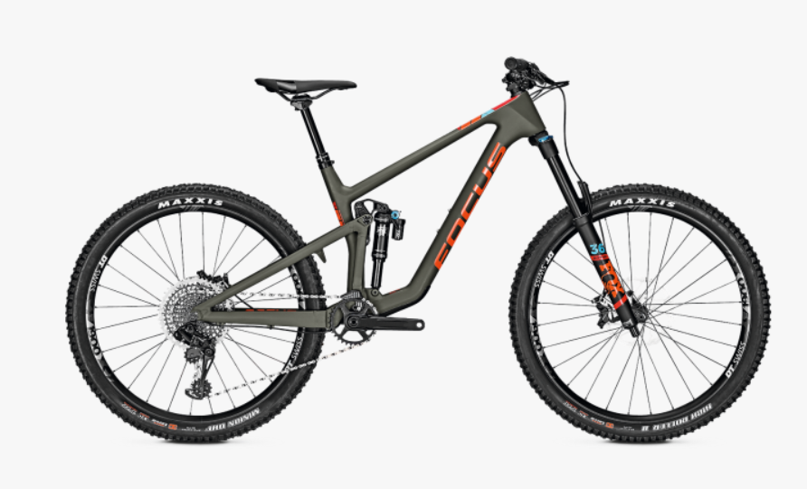
I bet that primer is just fine out there. Maybe just get 150 up front. Or get a rock shock dual position you can use 150 or 130My dilemma is this. I'm really excited to give this a go and thinking it will be a great riding venue for the summer time. Problem is, I've been a huge proponent of shorter travel (120-130mm) bikes for around here, with short chainstays and wheelbase for that playful feel. My 2017 Primer 29er has been perfect for me on everything I ride around Central Texas, but I think I'm going to want more if I start hitting Spider Mountain and possibly Cat Mountain. My 2014 Trek Remedy 29er would provide a little more travel and smooth out the bumps better, but it's old school geo with cramped cockpit and long stem to compensate. I think I'm going to want a modern, relatively slack (65-66 degree HTA) 27.5 with 150mm travel and relatively short chainstay and wheelbase. The newer 27.5 Remedy 9.8 would probably fit the bill, or maybe something from Germany like this Focus Sam.

Sent from my SM-G950U using Tapatalk
-
2
-
-
Not adding miles. Re vamping the existing ones with machines bruh. [emoji12][emoji12][emoji12]Was at Brushy and someone said they were adding 4 miles to Peddlers and are going to hold TMBRA races there? Uh...wut?
Sent from my SM-G950U using Tapatalk
-
If only there was a trail steward for Peddlers Pass [emoji2369]It shouldn't be blocked. Someone unblock it
Sent from my SM-G950U using Tapatalk
-
YesQuick question on Suburban Ninja... is the entrance at the Kati Ln cul de sac OK to use? I've been getting on / off a little farther up stream by going around the drainage pond at the end of Logan Ridge Dr. Would love to add some more dirt into the ride!
Sent from my SM-G950U using Tapatalk
-
I have never seen any snakes in there. Are you sure they weren't just earth worms and your fight or flight took over. [emoji38]
Sent from my SM-G950U using Tapatalk -
The easiest way to find the trail is to start at RedHorn /Peddlers . The trail head is just down the grass hill behind the bank and Sonic. But if you wanna access it from the bcrt you need to take that tunnel under pass under Brushy Creek rd. Then take the neighborhood street Walsh Trail the majority of the way . from there are a few different ways to get to the dirt trail. Zoom in on his strava to see one option. Or I van send more detailed turn list if needed.Thanks, where's the entrance? I usually start at Champion Park, do Candyland, then continue west and hit (most) everything until I get to the YMCA, then hit a bunch of stuff again on the way back (Dave's Ditch, Rim, Picnic, Peddlers, Candyland again). Would be a good way to end the ride since I start/end at the eastern section.. I've known about this trail, but completely forgot about it since I've never ridden it.
Sent from my SM-G950U using Tapatalk
-
3
-
-
Nice! That's my favorite route. Somedays it's a shorter variation.Thanks for the feedback on SB all. That worked out great!
The trails are in very good condition. Even east Peddlers and Mulligan. Brave the cold and get a ride in before that changes again.
Sent from my SM-G950U using Tapatalk
Brushy Creek
in Mountain Biking Discussion
Posted
Sent from my SM-G950U using Tapatalk