

June Bug
-
Posts
1,070 -
Joined
-
Last visited
-
Days Won
39
Content Type
Profiles
Forums
Gallery
Calendar
Posts posted by June Bug
-
-
On 5/4/2023 at 1:07 PM, notyal said:
Yeah, and good for them putting a new trail system in. I think we all agree, more trail is always better. I'm really not trying to shit on Borger. (The oil companies have already done that.)
The more interesting aspect is that someone or several people in this funky town decided they needed, really needed a trail for the homies, found the area to put in trails, got after it, and created a trail system and now there's a place to run, walk the dog, mountain bike ride. Maybe they rode in Palo Duro Caprock Canyon and decided they'd rather have a trail out the back door. It's just amazing to me that trails can pop up in the weirdest place because someone wants a trail system to ride their bike.
I think of Gooseberry Mesa in Utah, the Alien Run trails near Aztec, NM, Phil's World, and shout out to Mark H. @ Walnut Creek!
Side note: Alibates Flint Quarries National Monument is not too far away.
-
We got missed in North Austin.
-
Osprey is having their late summer sale: today - Sept 4: SALE
-
 1
1
-
-
On 8/14/2023 at 3:39 PM, Sluggo said:
I suffered from sciatica for many years before Skot at BSS suggested a wider saddle to help better support the sit bones (it only affected me off the bike). I don’t hurt anymore and no longer fear the little bastard in my right cheek going off at any moment. Hope you get it worked out.
I'll suggest this to Mr. JB, and see if it helps. His sciatica started just this summer.
This is a seemingly bad injury that just...faded away post.
This past Saturday we went to check out a dirt/gravel road that looked to have a good chance of going out to a point with an amazing view. The gravel ended abruptly, but a sweet, smooth and very rideable two-track continued through the Pondersa and aspen, so we were zipping along side by side at a pretty good pace. Then a dead, but very strong branch hidden in some oak brush grabbed my handle bar, yanked it hard right. I went left taking out Mr. JB and instantly we were down in a tangled pile of arms, legs and bikes. I went down hard on my left shoulder and it HURT, it felt like there was some kind of serious damage. Mr. JB was fine, but it took us a few minutes to extricate ourselves and I needed help getting up.
On the way home was trying to sort out who to go to: Urgent Care/ER/walk-in clinic, but went home first to get some of the dirt off.
Slathered on some hard core prescription pain creme with lidocaine and steroid foam that was on hand & decided to wait until Sunday morning for the walk-in clinic, because not hurting so bad. Next day, range of motion was good, there was soreness but no serious pain, and it all resolved over the next day or two. Went for a nice ride yesterday (Tuesday). All good. Amazed that anything that hurt so bad initially wasn't a severe injury, and resolved completely.
I had my InReach and didn't need to use it, of course, but it was a reminder that an accident can come out of seemingly nowhere in benign surroundings.
-
3
-
-
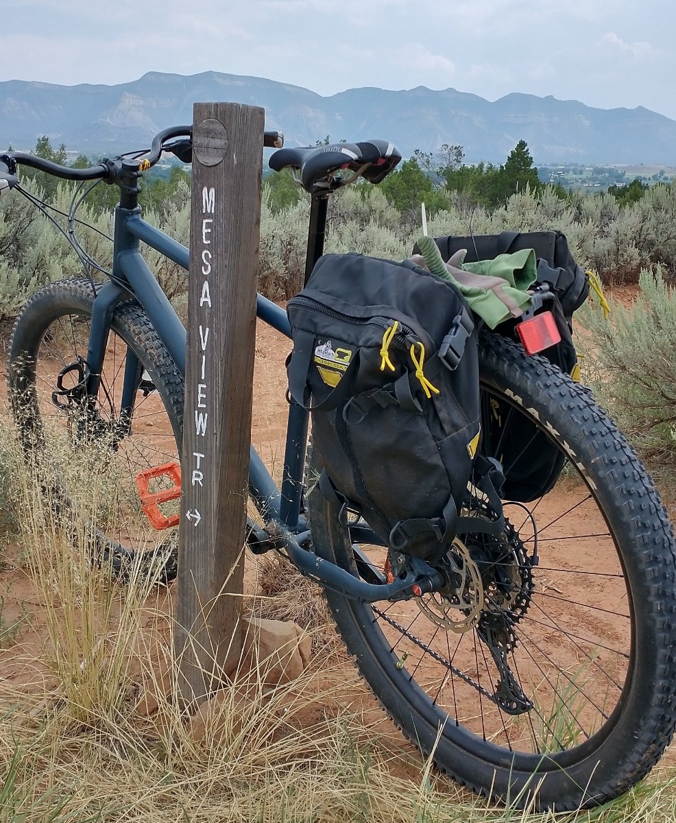
The mesa you're viewing is the north facing escarpment of the Mesa Verde cuesta. This section is the Ute Mountain Tribal Park, further east is Mesa Verde National Park. Foreground is a trail at Hawkins Preserve, right outside my door. Bike is set up for zipping about town, to go to the library, grocery store, farmer's market and other errancs. Also ready for bikepacking and riding around at Hawkins Preserve.

-
9
-
-
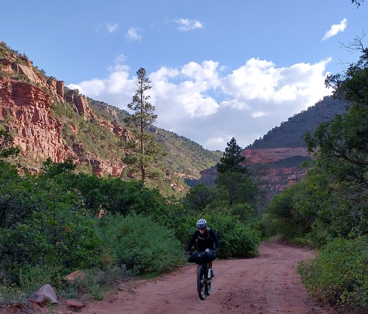
Last year we were in SW Colorado for several months. I'd had my eye on a dirt road in the Dolores River canyon bottom for an inaugural bikepacking trip.
We had pre packed, so we unloaded fully packed bikes and started in late afternoon.
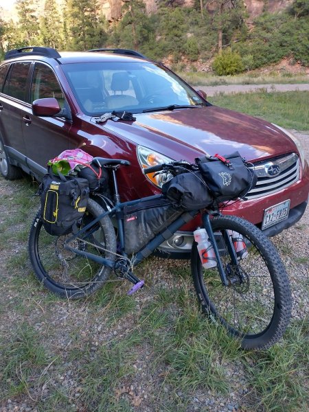 We had so much water -- bottles on fork, two liters in the frame pack, maybe a liter in a feed bag on the handle bars.
And off we go in the late afternoon sunshine. It wasn't too hard to pedal a loaded bike.
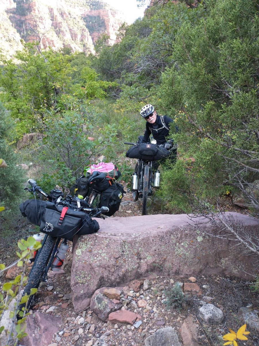
 And then we hit the first giant mud puddle. This one has just barely enough room to squeak by along the edge.
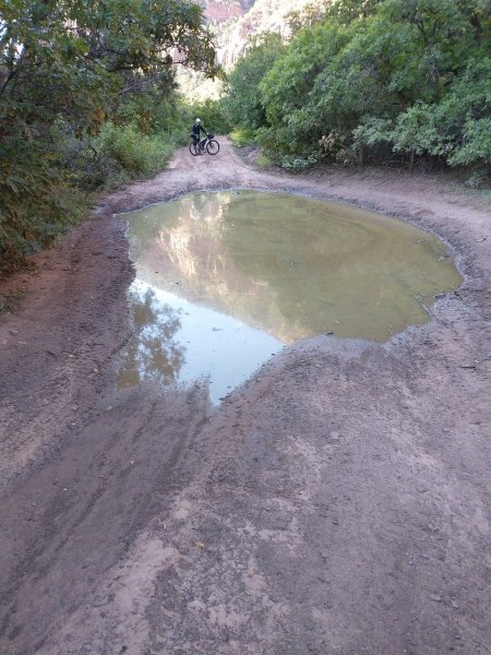 Every 75 yards or so there was another giant puddle and some had no way to get by. We tried bushwhacking. The oak brush was thick and it wasn't a satisfactory solution.
 Then, I tried riding around the edge of one last monster puddle, my front tire slid down into the soup about 2 feet from the end. It was so deep and there was so much ooze at the bottom that I couldn't pedal out. I put a foot out, and the water and ooze were almost knee deep.
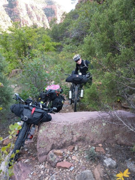
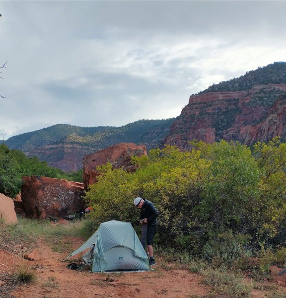
After that, we pedaled on a bit, found a nice campsite and settled in for the night and slept well.
 In the morning we pedaled back to the car. The puddles had receded just enough that we could ooch around the edges so got back to the car without too much trouble.
We're in the same area now so there will be a Round Deux in three weeks or so. The monsoons have been much more moderate this summer, so the road should be mostly dry.
The start of this ride is only about a 40 minute drive, so we'll probably do a recon for the first few miles before we return with loaded bikes.
-
2
-
-
On 7/25/2023 at 11:26 AM, June Bug said:
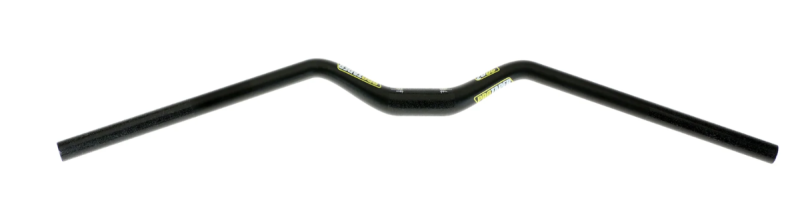
I'll take the Surly alt bar off the Hudski Doggler and transition that to the Salsa Spearfish. The Enve flat carbon bar on the Spearfish has been on there 10 years or so and should be retired.
So...final disposition of the bar thing. Went to Kokopelli in Cortez, CO. The Jones H-Bar, which was in stock, is basically the same layout as the Surly bars, so added those on. The old Elixer lever on the right side was somewhat damaged, a replacement brake hose was crazy expensive, so just made sense to replace it with a new Shimano brake.
The steering with an alt bar is not as precise as a flat bar, so there's a bit of adjustment. Overall, good.
-
1
-
-
On 7/28/2023 at 1:17 PM, RedRider3141 said:
I'd love to try them, should be the right size for me. I've been meaning to try and make the jump from tennis shoes to real MTB shoes.
Sent you a DM with info.
-
1
-
-
The Motorola Defy satellite link is now available for $149, and then you buy a plan. (The original price was supposed to be $99.)
"No cell coverage? No problem. Switch to satellite. Connect any smartphone* directly to satellite for text messaging check in and SOS."
The asterisk probably relates to the phone requirements? Couldn't find it on the website.
-
Free: men's size 10.5 Five Ten Free Rider Contact shoes
Mr. June Bug got a pair of over a year or two (three?) ago and they are just the tiniest bit too short, so he used them for a ride or two and that's it. These are the kind with a smooth sole.
Spread the word to anyone who might need them.
DM me and we can meet you at Walnut Creek Metro Park.
-
Thanks for this! I did have a thought bubble pop up that will be a bit less expensive option.
I'll take the Surly alt bar off the Hudski Doggler and transition that to the Salsa Spearfish. The Enve flat carbon bar on the Spearfish has been on there 10 years or so and should be retired.
Then I'll find a swept back bar with a lot of rise and put it on the Doggler since I need a higher rise on that bike.
-
Anybody showing up today (July 25, 2023) wear a men's size 10.5 shoe in FiveTens? Mr. June Bug got a pair of Five Ten Free Rider Contact over a year or two (three?) ago and they are just the tiniest bit too short, so he used them for a ride or two and that's it. These are the kind with a smooth sole.
Look almost new and free to whoever wants 'em. Spread the word to anyone who might need them.
Post up here, I'll DM you my phone # and you can text us when you're done with your ride.
-
Also check for even the smallest crack in the house where a sssssssssssssnake could get entry.
-
1
-
-
Picked up my bike from Bicycle House; the mechanic had proactively cut down the existing Ergon grip to work with the grip shift, so that's that.
Next is going to be a new carbon alt bar -- HayesBicycle.com is having a sale!
PROTAPER CARBON 20/20 HANDLEBAR
Regular price$174.99 USD Sale price$122.49 USD Save $52.50 USD
Sadly, the 720 mm width is no more; it's 780 only. May have to cut them down a bit.
-
2 hours ago, mack_turtle said:
Be careful with Urban Dictionary. You might find something you wish you hadn't read.
Yup, it's definitely saturated with adolescent sleaze, but one can scroll right by until you you find something like
skin dogs: Referring to ones own human children in regards to the opposite of fur babies.
I absolutely love my skin dogs, I have two daughters and a son - Brianna, Tyler and Mayleigh. But no one will greet you at the door like a fur baby! Stryker is my german shepherd puppy and he is so cute!
-
 1
1
-
-
21 hours ago, AustinBike said:
My wife's bike has grip shift, only on the right. Got a set of these on Amazon for $12.
Excellent possibility, but I'm confused by this: JooFn Bike Grips Handlebar 130mm & 90mm Lockable Handle Bar Rubber End Grip 0.874 inch Diameter for Multi-Speed Bicycle Mountain BMX Floding
So I googled "floding" (nada results), ended up wandering in Urban Dictionary and discovered "Barbenheimer" = seeing Barbie AND Oppenheimer, possibly back to back.
-
8 hours ago, TAF said:
Can't you just grab any old one and saw it off?
That may be an option. One cracked last fall and I replaced with a new set, but I don't know where the survivor of the original set got to.
I'd recommend staying in Salida for as long as humanly possible. I got excited today because I noticed that the forecast high temps may drop to *101* near the end of the current 10-day-forecast with some at least minuscule chance of rain.
-
An ask: does anyone have a spare shorty Ergon grip (just need one!)? They are used with Grip Shift and Rohloff hubs, like this: Ergon GP1 Gripshift Handlebar Grips
Will also check at yellow bike project.
The Spearfish is at Bicycle House waiting for its left side Grip Shift (to shift double chainrings). Mechanic said he thought that set up could work, although there may need to be a new dropper seat post lever.
random info: Grips for a Rohloff hub have one short and one long, cause you are only shifting on one side. For Grip Shift, it's two shorties. I'm assuming nobody with a 1 x uses GripShift, but if so, they'd just get the Rohloff set.
-
On 7/14/2023 at 9:09 AM, AntonioGG said:
I hate the horse flies too. I was bitten >20 times once at Emma Long through my bibs. I had nightmares about that for a while.
Was at Palo Duro at the end of a rainy May. They were biting my "flanks" through my bike shorts, even after drenching skin and clothes with something DEET based. They were undeterred. Could be related to this:
Pestworld.org: "Adult horse flies typically feed on nectar, but females require a blood meal before they can reproduce effectively. Female horse fly bites,especially in large specimens, can be quite painful because their mouthparts are used for tearing and lapping, as opposed to mosquitoes which simply pierce the skin and suck blood."
Picaridin and citronella-based repellents may or may not work.
-
On 6/26/2023 at 9:17 PM, mack_turtle said:
But i keep hearing randos saying that they wait to go outside when it's well over 100° in late afternoon and go running or just sit in the sun and wait for death, apparently. Are they mutants? Did They make a deal with the Devil? Are they just trolling?
Mr. June Bug, who is 78, thinks nothing of hopping on his bike at mid day for a 30-mile ride in 100 degree heat (although not since things are topping out at 105). He's come home every time under his own power and doesn't seem to be demon possessed, but damn! I don't like cold weather, but my heat tolerance keeps dropping.
Tomorrow I'm planning to ride to a swimming pool that opens at 8 am (maybe Walnut), do a water workout and ride home, getting back no later than 9:30. Balcones (on Amherst) and Beverly Sheffield North West Dist Park on Shoal Creek are also options. Each one is closed one weekday.
-
Side note:
Bikepacking.com posted up the WeedSac 140 route -- a loop in the Sacramento Mountains with a start/finish in Cloudcroft.
FRIENDS IN COW-PIE PLACES: FIELD NOTES FROM THE WEEDSAC 140
Any part of it could be a day ride and the detailed elevation profile can help you avoid this: Encompassing 140 miles and 14,000 feet of climbing through the Lincoln National Forest, it’s a collection of their favorite canyon descents strung together by long climbs to get to the top of the next slide. This includes a 27-mile continuous ascent midway through and a leg near the end that rises more than 2,000 feet in just 7 miles.
Prior to seeing this loop, I'd thought about setting up a shuttle (maybe to La Luz Canyon?) at a higher point, riding, camping and finishing in High Rolls, mostly downhill.
I checked the Cloudcroft 10-day weather report and it does look like a monsoon pattern is in play.
-
That's a Paul Uhl decorative platter hanging on the tree trunk on the left!
-
1
-
-
I do have two bikes with a 1x drive train. At first I kept trying to down shift to that little chain ring, but that was short lived before I remembered that there was one and only one chainring.
I'll try the grip shift option if it's compatible. Then 1x if it's not.
-
1
-
-
Dear Hive Mind,
I have a 10-yr-old Salsa Spearfish. I still like it and it's going strong. It's a double chain ring set up that works just fine.
Then last fall I got a dropper seat post. There isn't enough room for the shifter levers for the double chain ring and the dropper seat post lever to work together. It's awkward and easy to either miss a shift or miss the dropper seat post activation for up OR down because nothing is in the right position.
I was considering going over to a 1 x set up, then came across someone on the facebook Cylists 70 and Over page who had switched over to a grip shift on the left side for some reason.
I've had major problems with hand numbness in the past, but could always shift with Grip Shift. Another plus is that one can buy short Ergon grips to work with the shorty grip shift.
This would be a potentially economical and practical solution for an old bike that works well.
Any down sides or incompatibility issues that come to mind?
I think the item would be the SRAM GX 2 speed:
MODEL ID: TS-GX-11-A1https://www.sram.com/en/sram/models/ts-gx-11-a1
-
1
-


Random Bike Pictures
in Mountain Biking Discussion
Posted
Yes, it's amazing. Lots of variety.