

June Bug
-
Posts
1,033 -
Joined
-
Last visited
-
Days Won
31
Content Type
Profiles
Forums
Gallery
Calendar
Posts posted by June Bug
-
-
Twitter today:
@EvilMopacATX: This week Austin is going to feel like a Honduran jungle had a three-way with an iron smelter and the core of a nuclear reactor.
We bought an acre lot in Cortez, CO (southwestern CO) in Oct., but even putting a small modular home on it is going to be crazy expensive - realistically minimum $175,000. Just hooking up new utilities (gas, water, sewer, elec are all at the lot line) is ~ $15,000.
Finding a renter for the winter months would be easy, though. The housing stock is low and everything is crazy expensive -- think the equivalent of Austin housing prices in Cortez and abt $100,000 higher in Dolores, 9 miles up the road and 1,000' higher in elevation.
In a bit we're driving up there to check out a fully furnished "condo" (apartment in a house) to rent for Aug - Oct. in Cortez. Hawkins Preserve for hiking (also bike-able) is literally out the back door and I noticed some other trails/paths very close by. Geer Natural Area has some hills with a mtn bike trail system on the north end of town. Phil's World is about a 12-minute drive and at some point, a bike/pedestrian path will go from Cortez to Mesa Verde National Park entrance. That path will go right by the fairgrounds, which are across the highway from Phil's World, so connectivity happening.
The economy in Cortez has always been driven by tourism and they are very aware of the amount of tourism pulled in by mountain bikers and other outdoor pursuits.
Buying a "previously gently owned" travel trailer and living in it in a shady RV park might be the better option for three or four summer months, then store it for the winter in Cortez or Farmington.
-
 5
5
-
-
9 hours ago, AustinBike said:
You don't want a second state trying to claim capital gains on you.
...or pre-emptively hitting you up for state income tax...
-
I haven't had a chance to try Turkey Springs, but it's on the list.
-
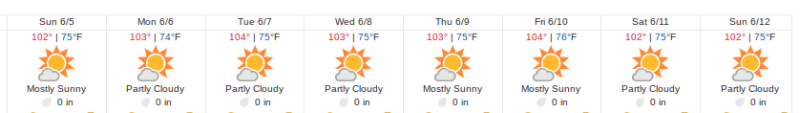
I'm usually a weather eagle and know the 10-day forecast, but it caught me by surprise when a friend posted this insanely hot long-term forecast on fb today.
It doesn't matter which trail, these are danger zone temps -- between 102° and 104° starting Monday and going through the following Sunday. Who knows after that. Even if the forecast drops by a few degrees, crazy hot.
-
Paul Uhl tells me that Hwy 518 from Las Vegas to Mora and Hwy 434 from Mora to Angel Fire is open. He drove to Angel Fire using that route a few days ago.
-
Speaking of hydration, the Target store in the Arboretum/Gateway area (183 @ Great Hills Trail) has
- Nuun tablet (various flavors)
- Skratch in single packets and small bulk bags
- Honey Stinger waffles (gluten free and regular) and chews.
It was somewhere in the sports/yoga section.
-
1
-
Update from BikepackingRoots.org:
BOLT Act update! A couple weeks ago, the Biking on Long Distance Trails Act took a big step forward in the U.S. Senate, advancing out of committee as part of a small package of public lands bills! That means the next step for the BOLT Act bill is a vote in the Senate! Why are we excited by this? This legislation will help propel forward the creation of new long-distance bike routes on public lands. Bikepacking Roots has been working with @imba_is and @adventurecycling to refine the language of the bill and push it forward, a collaboration for which we're grateful.
What can you do to help? Submit a letter of support at the link below - there's a bit more background on the bill there, too, as well as a link to our advocacy toolbox where you can learn how to write a powerful short letter!
-
2
-
-
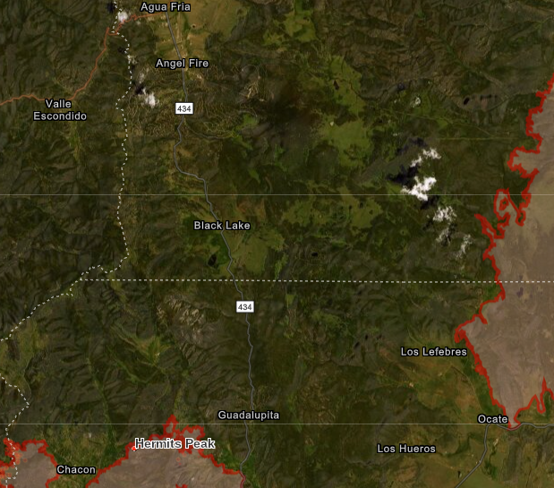
But back to Angel Fire. It's about 13 miles from the northern extent of Hermit's Peak fire to the beginning of the Angel Fire development. The fire doesn't seem to have advanced to the north over the last week or so and shows no thermal hotspots.
The fire on the right is the Cooks Peak fire, which doesn't show as a named fire on InciWeb or ARCGIS so maybe it's done?
-
13 hours ago, Barry said:
Not sure what I missed here, but I was making an Angostura Bitters joke...
(Gah! I totally missed the reference.) *Raises drink* Sláinte!
The little turquoise squares are cabins and other structures. The pinkish area with a red outline is the extent of the burn. The map doesn't show any active thermal hotspots, so still safe for the moment. The fire, which is now 300,000 + acres, may not be out until July, if the monsoons start.
-
Deleted. -
4 hours ago, hurronnicane said:
Nice ride this morning at my personal trail network. Never got too hot.
Mornings have been lovely, almoooooost on the cool side! Are y'all doing a long road trip this summer to escape from the heat?
-
1
-
-
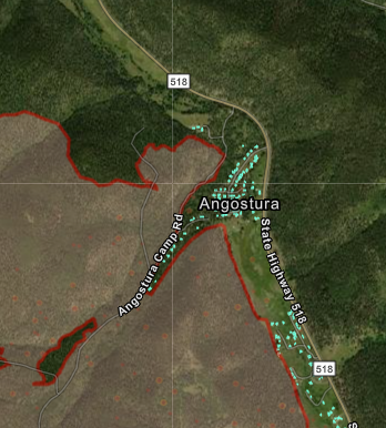
Two different friends have cabins in the Angostura area by Hwy 518. The fire was within 2 miles when the winds changed yesterday and they were spared for the time being.
ETA: Today (Saturday) about 1.7 miles away.
The north end of the fire is now 15 miles due south of Angel Fire.
-
1
-
-
2 hours ago, Hugh said:
IIRC, you lived in Cortez? I was thinking about camping at McPhee Reservoir. Thoughts on that?
My favorite place on the planet!
McPhee Reservoir has some kind of formal status as a national recreation area, so camping is allowed only at the few developed designated campgrounds.
House Creek Campground, info HERE.
McPhee Campground is on the other side of the lake.
There's nothing rustic about these campgrounds - they are developed and there will for sure be a fair number of RVs. Not cheap, check the web sites but it looks like "standard" campsites are $26/night. We drove to House Creek Campground one time just to check it out and there was hardly any shade.
A really nice private campground that does have some tent camping right by the Dolores River is Dolores River RV Resort. Lots of big trees, lovely. Looks like a tent site would be $32/night, but the campground does have WiFi, so there's that.
I just called the Tres Rios Public Lands Office (combined Bureau of Land Management + San Juan National Forest) just outside of Dolores, and confirmed that there is still dispersed camping all along Boggy Draw Road, which is by the extensive Boggy Draw Trail System, many many miles of mellow single track in the Ponderosa Pines, just a mile or two above Dolores.
The super mega everything map for all SW CO singletrack is put out by biglooptrails.com/colorado-trails They seem to be doing a good job of creating new editions to stay current on all the new trails being added to both Phil's World and Boggy Draw.
You can get a digital version as well, but I'd recommend the paper option for your personal sanity and the great overview.
If you're in north Austin (Walnut Creek area) I'll be glad to share my maps with you. Just PM me if you'd like to meet up. We're retired, so mostly open schedule.
-
3
-
-
Monster (over 200,000 acres burned and hardly contained) and extremely dangerous fire burning between Las Vegas and north and west of Mora (Calf Creek/Hermits Creek Fire). I'd assume that you can't access Angel Fire on 518, then turning onto Hwy 434 at Mora, but who knows what conditions will be in a few weeks.
There is also the Cooks Peak Fire burning east of Angel Fire, but it's possibly close to containment.
Re: Yes to Phil's World but if it's warmish in Cortez, and you have riders with you that aren't so much into the tech, don't overlook Boggy Draw trail system 9 miles north of Cortez and just above Dolores -- over a 1,000 ft higher in elevation. Boggy Draw has a lot of mellow cruising in the Ponderosa pines; it's a huge trail system now.
If for some reason it's on the coolish side, there's Sand Canyon trails down McElmo Canyon west of Cortez. Lots of nice red rock, just like in Utah.
That's the great thing about that area. Lots of variation in elevation. If it's hot go high. Too cool? Get down in the canyons.
Kokopelli Bike and Board is the local shop in Cortez and they now have a little shop in Dolores across the street from a brew pub. They have great Phil's World t shirts and will likely have the master map to all the trails in that general area.
Enjoy. We'll be in that area mid summer.
-
Gave the Spearfish a nice bath and got it over to Bike House. Dodged multiple bullets. Turns out a brake bleed did the trick and if I need to replace the brakes in the future, there is ongoing SRAM compatibility between the brakes and the shifters; they will play nicely on the handlebars.
I asked about a creak, and a likely culprit is a plastic spacer in the press fit bottom bracket. Will replace with a metal spacer when the time comes.
Really nice shop; turns out there a time slot available just when I dropped by with the bike, so very quick turnaround, like I was home for less than 15 minutes quick when they called for me to pick it up.
It's easy to miss the shop the first time. It's on the west side of Burnet, next to what used to be the light bulb shop, and still has the big lightbulb on top.
-
1
-
-
Thanks for the feedback, AB!
Yes, Mr. JB attempted to bleed the first set of Avids, which was a frustrating and ultimately unsuccessful exercise.
Last Oct. when we were in Colorado, a small, recently opened bike shop bled the brakes for me. The repair area was a bike stand behind the front desk and the mechanic/owner/sales guy had two syringes of brake fluid, one in each hand. Effortless for him, while he carried on a conversation with Mr. JB about bike stuff.
Kokopelli Bike & Board Dolores, across the street from Dolores River Brewery
-
I've had two sets of Avid Elixers on two different bikes. The first set worked flawlessly for many, many years until front and rear decided to die simultaneously. Pffffft! Having them rebuilt at a bike shop cost more than buying a new set of Shimanos, so Deore hydraulics are now on that bike.
Now I'm five (six?) years into another set of Elixers on another bike and the rear brake died last night at Walnut. Oddly, can't find any fluid leaking anywhere, but the brake lever was almost at the handlebar.
Anyone used REI Gateway for bike repairs?
Alternately, may try Bike House.
Either way, *off to give the Salsa Spearfish a nice bath first*
Will probably go with Shimano XT for replacements.
-
The rain shower was so short that I only realized it when I saw the back patio was wet; it was not a deep "soaking" rain. I suspect it will be fine late this afternoon and evening.
-
Know before you go: April 28, 2022 Reveille Peak Ranch posted on facebook a few minutes ago: "Still not happy…because of a fire on an adjacent property, trails are closed this morning. We’ll post an update when they are open. Thanks for your patience!"
-
On 4/16/2022 at 4:16 AM, Jessica said:
we just bought tickets to Grand Junction for 9 days between June|July. The plan is to bike Grand Junction, Telluride and Fruita. Flirting with the idea of Slick Rock.
I've heard a lot of good things about the trails at Ridgeway State Park.
-
15 hours ago, Sluggo said:
Tanning balls may help.
and
1 hour ago, notyal said:If there is a problem ball tanning can't fix, I haven't found it yet
So, exactly parallel and 100% germane to this discussion. Are you going au naturel or artificial light?
-
 1
1
-
-
13 hours ago, Sluggo said:
Cheers to Summer trips🍻🍻
Indeed. What's the location?
-
On 4/4/2022 at 10:43 AM, Barry said:
I did NOT consent to my marketing copy have 3 font sizes and 2 colors though.
The yellow text on blue background has some Slava Ukraini vibe, so there's that.
-
1
-
-
22 hours ago, AustinBike said:
...then over to the north trail,
That's the problem right there. How would you navigate from the end of the SWCT over to north WC?
-
1
-
Angel Fire
in Mountain Biking Discussion
Posted
Boggy Draw is lovely and now quite extensive trail system.
We just rolled into Cortez. It's a bit on the warm side, so likely we'll head up to Boggy Draw tomorrow.