
cxagent
-
Posts
609 -
Joined
-
Last visited
-
Days Won
28
Content Type
Profiles
Forums
Gallery
Calendar
Posts posted by cxagent
-
-
37 minutes ago, AustinBike said:
Might be doing a midweek ride up there in early December if anyone is interested in tagging along.
That depends. Is this close to the river???
-
I always get those Creek Rock places confused too. But I can tell when I am riding in Central Texas or New Orleans.
Oh wait - different thread jack.
-
 1
1
-
-
Sometimes called a thread hijack.
Nobody in their right mind would ride Reimers on flat pedals. (See how I kept it at least close to on topic???)
26" wheels are where it's at. Anything larger is 'just a fad'. Reimer's doesn't do fads. (still on topic) But the Mississippi River trail are just fads too. (Opps - now off topic again.)
Anybody riding in Colorado this week? (Opps, off topic again.)
No - I'm heading to Moab next week. (Opps - where is the Moab thread? Oh wait - we don't even try to use threads on here. My bad.)
Anybody know if the trails are dry in Norleans?
-
I have a fair amount of 2x4's if you need some. PM me if you need some. I can even deliver given some advance notice and a drop off location.
-
 1
1
-
-
You guys are do L O N G rides from Reimer's Ranch to Gulfport???? DAMN!
If not - why don't you start a thread on the area you are talking about? Or PM each other. Or change the title of this thread to "Reimer's Ranch and Mississippi River Related Trails"?
-
 3
3
-
-
13 hours ago, Cafeend said:
I havent drank since 92, I havent smoke cigarettes since 98. But no way am I giving up BBQ and ice cream. Oh,, And no more strippers . Damn.
You may not actually live any longer that you would have without those changes. But it just seems longer...
-
1
-
1
-
-
You spend Saturday morning working with a group of volunteers then go back on Sunday to do the heavy work you did not want volunteers to be around. Like volunteers being too close to me swinging a Pulaski to chop out roots.
You might be a trail builder...
-
1
-
-
Damn!
I forgot to ask permission...
-
30 minutes ago, Jbn999 said:
If you want volunteers to show up, you need to tell them what to show up to.
Give me a break.
Sorry you did not get a formal invitation.
PM me your email address and I will send you an email. (Don't post your address in the clear because it attracts spammers.)
-
1
-
-
5 hours ago, AustinBike said:
It's already on google maps.
Be careful using Siri. That bitch took Mrs CX to the Colorado River end of Country Club Creek instead of the trail.
-
4 hours ago, Yosmithy said:
Haha, that seemed like a great place to take a picture too


Sent from my Pixel 2 using Tapatalk
The ledge up looks doable. So you can start hucking it now.
-
I went back out there today to pick up a missing tool. While I was there I opened up the trail a bit more. Still lots to do but it keeps getting better and better.
And we got some good press - https://www.fox7austin.com/news/buzz-mill-coffee-hosts-my-park-day-cleanup-at-the-country-club-creek-greenbelt?fbclid=IwAR38xtxFvRhvC-363hLR7lzv153I3lzk-3ptHBMysV0D0M1IE7t8nRLiLGg
There is supposed to be more on the Fox7 Blog but I have not found it yet.
-
1
-
-
Well if we had built the Williamson Creek Trail - I would have an answer for you. But I don't.
-
1
-
-
I thought I had already posted about this new trail in southeast Austin. I could not find such a thread even when I searched for it. So here it is -
The Austin Ridge Riders has built a new trail on a PARD property called Country Club Creek Greenbelt. It is at the dead end cul-de-sac on South Pleasant Valley south of Oltorf. There is not much parking so it is best to ride to the trail. There are sidewalks and bike lanes that make that pretty easy.
The trail is just over 2 miles long right now. Given time it may be extended - there is a lot more land that could be used. The trail is on the easy side - think easy trails of Walnut Creek or SATN. There is not much terrain that works for more technical trail. There are few rocks (almost all dirt) and limited elevation change. Much of the "technical features" are tight trees or off camber dirt single track. It can still be a fun ride even though it will never be a BCGB kind of trail. A lot of people are riding cross bikes on this trail.
The reason I was here to post about it is we had a work day on 11/2/19 for "It's My Park Day". We had over 30 volunteers and got a TON of work done. Buzz Mill (local coffee/beer/restaurant) got almost ALL of the volunteers through their 'Lumber Society' social / education group. They even got Horizon Bank to turn out volunteers to build trail. Mountain bikers??? We had two. Myself and Tip led work crews. We had more volunteers walk by, ask what was happening and join up than we had MTB'rs. How embarassing for MTB'rs.
If you have the chance - go ride it. The more wheels we get on it the better. Use a map program like Google Maps to find the dead end cul-de-sac on South Pleasant Valley south of Oltorf. From the south end of the cul-de-sac take the big side walk to the south. Before you pass the big rock wall (maybe 100 feet) turn left across the grass so you parallel the rock wall. Very shortly after you start between the rock wall on your right and the trees to your left, you will see the start of the trail take off to the left into the trees. We have laid some brush across the grass next to the wall to help guide you onto the trail. (That brush keep being moved so don't count on it being there.) After you ride 100 to 200 feet through that little section, you will pop out onto a cleared area where you can see the cul-de-sac to your left. Follow the trail to the right and vere right where the smaller trail splits off to the right. This will take you thru another short section of trees with a small "dry creek" crossing then a series of climbing switchbacks (not steep but you are climbing). About 200 or so feet of single track you cross the cleared gas line easement again. This time you dive into the trees and single track for a good while. Keep the red flags or spray paint on your right and the green on your left. You will cross several of the cleared gas line easements repeatedly. The whole trail is a bunch of parallel 'switchback trails' that are about 30 feet apart. Keep the red on your right and green on your left or you can accidently jump from one to the next parallel trail. As the trail gets ridden in, it will get easier and easier to follow. Right now the leaves falling on the trail tend to cover the trail so it can be more difficult to spot.
If you want to bail - go up hill. Follow the gas line easement if you find any. When everything seems to be downhill, look for the huge metal power line pole that is at the end of the cul-de-sac. It is just visible above the trees.
If you are on Facebook I have posted maps and video there. I will add them here when I get time. It is on Strava as Country Club Creek GB (aka Mazed and Confused). Those map/video were made when we first got the trail 'passable'. We have opened it up a lot since then. And we will keep opening up the trail and start doing the tread work. Come help if you can.
Strava - https://www.strava.com/segments/20959214
Video of early ride (trail is much wider now) -
-
There have been at least one and I think several Cranksgivings at Reimer's Ranch. I worked the one I know for certain four or five years ago.
-
Yet another delay in getting the new trail built. Latest prediction is that permission might be granted mid November to maybe December. Good thing I set a schedule deadline of September 1st. Too bad a forgot to mention what year.
Patience. Patience. Remember government move S L O W L Y.
Years ago we had a saying about lining something up with a tree so you could tell if it was moving...
-
1
-
-
18 hours ago, chuckt said:
WTF... I'm guessing this wasn't a sanctioned trail mod.
Huge rock moved off trail to make the line between the drops (squeeze play) a little easier.
I personally don't like hucking off either of them because of the tree gate it created there, but damn.
It's gonna take a couple people to get it back in place.


Sent from my SM-G930P using Tapatalk
People just amaze me. Is the sign still there that warns people that the trail is "hard" and to NOT change the trail???
-
Once. The conversation afterwards was short and to the point.
I guess that was often enough since it has not happened again.
-
18 hours ago, bestbike85 said:

If I said anything it would make Charlie193's comment look weak. Some people amaze me.
-
16 hours ago, Yosmithy said:
Ok, after this, it's settled.
I'm taking Friday off and riding Reimers.
Haven't been out there for years.
Call first. Reimer's is one of the places that closes the trails when it is too wet.
-
1
-
-
5 minutes ago, Yosmithy said:
Well, at least you know it wasn't me. I don't use paper, just my glove.
I am NOT shaking hands with you.
-
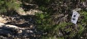
On 10/23/2019 at 12:50 PM, The Tip said:
I want to observe some trail activity. I'm not very tech adept. If I get one will I get frustrated trying to make it work? I would like one that would send something to my phone when it detects movement.
Any recommendations or advice?
If you want it to send data to your phone it has to have its own cell phone/number. I was not willing to pay that much for something that other people could play with or steal. Here is one - https://www.amazon.com/Cellular-Trail-Cameras-Waterproof-Activated/dp/B07Y2HQ8Y4/ref=sr_1_32?crid=3MVSG8EYB1KXW&dchild=1&keywords=game+cameras+with+night+vision+motion+activated+waterproof&psc=1&qid=1571940655&sprefix=game+camera%2Caps%2C1627&sr=8-32
I was using ones similar to this - https://www.amazon.com/Moultrie-A-25i-Camera-Kit-MCG-13299/dp/B07G2K1QXJ/ref=sr_1_28?crid=71YQDLR5ZKI7&dchild=1&keywords=game+cameras+moultrie&psc=1&qid=1571940774&sprefix=game+cameras+mou%2Caps%2C155&sr=8-28
Make sure you buy a lock and use it everytime. I also started putting up cameras in pairs. Each camera took pictures of the other camera. Then I had pictures of who was messing with the cameras.
They are not hard to setup and use. It does take some time to program it, install it, lock it and download it.
Will you get frustrated - yes. But that comes with trying to deal with the public on trails with or without game cameras. I found the game cameras were the ONLY way to solve some of the problems. Tip - you know about some of the problems. Nothing short of pictures to prove who was doing what solves some problems.
-
1
-
-
The build has not started yet. We are fighting like crazy to get the paperwork in place to build these trails. The lawyers got involved so what should have been easy has become a nightmare.
The new trail will not "join" to the existing trail. But you will be able to join them by riding across the road near the maintenance building. If you look at the north end of the map of the new trail, you can see the maintenance building marked. If you look closely at the very north edge of the map- you can see the exiting mountain bike trail.
-
3
-
1
-
-
I want one that points behind me if I'm riding on the road.
-
1
-
Where to start w/ trail building?
in Mountain Biking Discussion
Posted
Use the IMBA guide to sweet single track. You can find other people (National Park Service, US Forestry Service, etc) have books based on the IMBA book available for free online. Here some links -
https://www.nps.gov/noco/learn/management/upload/NCT_CH4.pdf
https://www.nps.gov/noco/learn/management/ncttrailconstructionmanual1.htm
https://www.fs.fed.us/t-d/pubs/pdfpubs/pdf07232806/pdf07232806dpi72.pdf
Nothing beats experience because all the reading gets you started but seeing what works and what fails makes a bigger impression.