
cxagent
-
Posts
609 -
Joined
-
Last visited
-
Days Won
28
Content Type
Profiles
Forums
Gallery
Calendar
Everything posted by cxagent
-

Can bike shops pay the bills just off service?
cxagent replied to The Tip's topic in Mountain Biking Discussion
When they ask for my phone number I tell them - "9 - 1- 1. Because if ANYBODY EVER calls me it will become an emergency." -
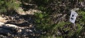
That saying to remind people of coral snakes (kill a fellow - https://en.wikipedia.org/wiki/Coral_snake) vs scarlet kingsnake (aka milksnake https://en.wikipedia.org/wiki/Scarlet_kingsnake). The original picture was a copperhead. They are everywhere but people rarely see them. They hide and are very well camouflaged.
-
The heat is on full-blast. Are you riding?
cxagent replied to mack_turtle's topic in Mountain Biking Discussion
I did about the same on Friday morning. Planned on 30 miles. Started about 9:00 near Sunset Valley. Rode to Slaughter Creek Trail. Started feeling it on 1826. Needed a break near Discgo - Discgo / Phoenix. Another break after SCT. By now it is getting hot. Needed another break near SH45. I finally bailed to Escarpment about 1:00. Yes my pace had slowed to a crawl. Just about passed out waiting for the light at Escarpment & SH45. Another break and more water at the Fire Station. I made it the HEB at Escarpment and Slaughter. Bought some refreshment and water and went back outside to sit on the bench where I could watch my bike. Just about passed out again. Had to lay down and put my feet up. Retired nurse saw me and recognized the problem. Tried to get me inside but I wouldn't abandon my bike. She gave me ice water and a cold compress repeatedly. In about 30 minutes I was much better. I can't imagine what could have happened if I hadn't bailed when I did. The heat can be a killer. I have ridden in this before. I don't have it in me right now. Be safe out there. I right early morning or late night now. -
The heat is on full-blast. Are you riding?
cxagent replied to mack_turtle's topic in Mountain Biking Discussion
Try this one - https://www.wunderground.com/history/daily/us/tx/austin/KAUS Scroll down near the bottom to get the hourly weather history. -
City & County Parks Closed This Weekend
cxagent replied to WhoAmI's topic in Mountain Biking Discussion
Brushy is mostly Wilco. I have not seen where Wilco is closing anything - yet. But I will go look. Go ride early before the idiots are out. ETA - Wilco web site was updated today and shows most things to be open this weekend. https://www.wilco.org/parks -
Hurray! Austin Bike will be back soon. Even if he is wrong about the steep climbing and the single speeding. Several of my recent "events" have been blamed on the same thing - I am just getting old. While I can't deny that, I don't think someone in decent physical shape just over night "just gets old" and starts having problems that didn't exist the day, week, month before.
-
South Austin Trail Network, The SATN
cxagent replied to The Tip's topic in Mountain Biking Discussion
SATN is not where I would go for tech. Nearby is BCGB. Or Emma Long. You can find good info on www.AustinBike.com. -
"nadge" neoquialism for CenTX trails
cxagent replied to mack_turtle's topic in Mountain Biking Discussion
I'm not saying a word. We have lost enough of my favorite trails. But if I were to say something - City Park. Emma will get ya! -
There were several (4 or 5) Flow Trails planned. ARR and KOM were stretched tight to get one flow trail built and open. There are plans to build a parking lot at the top of the Flow Trails. Travis County will have to build the parking lot. It is not in the current Travis County budget. A parking lot may not happen for years, it at all. In order to get the trail open as soon as possible - temporary signs were installed. I don't know how those signs have faired since I have not been there in months. The Return Trail and Flow Trail were beat in pretty good and the signs were up and readable the last time I was there. Travis County has put up some 'used road signs" (One Way, Do Not Enter, etc.). They seem to have a source for those ARR does not 😉 I hope that people will use and enjoy these trails and not get hurt. If you like them, please tell the park staff. Good feedback will help get more trails opened. Like maybe more of the flow trails that are already planned for Reimer's Ranch.
-
I would ride the normal trail and cut over for a few laps on the Flow Trail. Here is my recommendation for finding and riding the new trail - Park in the Mountain Bike Parking Lot - not anywhere along the road or near the Maintenance Building (that road has a sign saying "Authorized Access Only" or something like that). Ride the 'normal loop' until you are ride the 'Camron Park Vortex' like section. Start looking to your right. You will see a big while metal building with a small parking lot and a horizontal white water tank. That is the Maintenance Building. (Don't go near the Maintenance Building or bother the staff that may be there.) Between where you can first see the Maintenance Building and the barb wire fence, find a place to turn south toward the Maintenance Building. Depending where you turn right, you will find a paved road (turned early) or a dirt road (turned late). Take that road to the east (the general direction your were going on the Mountain Bike Trail). As you follow that road it will fork just east of the water tank (couple hundred feet?). Take the right fork and start looking to your right for the trail that takes you to the start of the return trail. From the fork in the road to the trail is about 100 - 150 feet. Climb up that small hill from the road and follow what should be a well beaten in new trail. In about a 1/4 mile you will find a T in the trail. To the right is the end of the Flow Trail - don't go that way. There are Do Not Enter / Wrong Way signs. The Flow Trail is ONE WAY down hill to prevent head on collisions. To the left is the Return Trail. Take the trail to the left. You will climb a slow easy approx one mile Return Trail. There is another T at the top of the Return Trail. The left of the T will go to the Flow Trail Parking Lot when it is built. Don't go left. The Flow Trail is to the right. It should be well marked and getting beaten in so it is easy to follow. Everything is tame enough for most mountain bikers to ride over. But I suggest you take a 'warm up / spotting lap' before you send it. There are some surprises. Jumps that turn up the face. Gaps that will surprise you. Once you see it - I think everyone will be fine with it. But if somebody sends it before that scope it out - I know which rocks you will end up on. Let me remind everyone that Travis County, being a normal risk adverse government agency, is concerned that people will get hurt on the Flow Trail. It has taken a lot of hand holding and reassurance that 'the public' is responsible for themselves and can take care of themselves. I can already hear about how 'the trail was so dangerous that it had to be closed' if people start getting hurt. A warm up /spotting lap is not that big a request before you send it. If you want to ride the Flow Trail and only the Flow Trail - Park in the Mountain Bike Parking Lot. Follow the road back out like you were leaving the park. Just past the horse stable / horse trailer parking, start looking for a paved road to the left. There is a sign saying "Authorized Access Only" or something like that on the road you are looking for. Take that paved road to the left. Follow it past the Maintenance Building and the water tank. Follow the directions above.
-
I refer to them as "Austin's Protected Class". If you or I did the things they do we would be arrested/ticketed. They are rewarded. The places they live need to be known as "Adlerville" in honor of His Majesty, wait, I mean Mayor Steve Adler.
-
Sorry. I didn't mean to leave you out. I heard about it from Chardog so I assumed it was his baby.
-
Don't talk about the fight club... And don't YouTube it. Or Strava it. Etc. Etc. Etc. Only those things seem to be impossible these days.
-
I think you mean the Southern Walnut Creek Trail (sidewalk) that runs around the east side of Austin. CharDog submitted a plan about 10 years ago to build trails there. The City considered it until some tennis pro named Andy Roddick said something about building a tennis center on the flat land at the top. PARD put the whole thing on hold while they developed a "Master Plan". We are still waiting. I would not hold your breath on anything happening in my lifetime.
-
South Austin Trail Network, The SATN
cxagent replied to The Tip's topic in Mountain Biking Discussion
The BCGB "entrance" across from Rudy's was closed about 10-15 years ago. There was a pedestrian killed crossing 360 to/from get to the creek. Willie Conrad (BCP Secretary for years) decided that people crossing or getting killed was not a problem - but don't let them create a trail across BCP lands. The news stories just sent them out looking for new trails. I googled and quickly checked my notes but did find anything to nail down the year. -
Up north try Walnut Creek Point 6 and Inner Log Loops (not Outer Log Loops). Peddlers Pass was built to allow Honey Badger's kids to ride it. It has picked up some slightly more difficult areas but they can walk those short sections.
-
I would make the comment (Please don't ride muddy trails). Then asked for help repairing the damage. Expect to get 'less than helpful responses'. Public shaming is never a good choice unless there are multiple examples of continued problems by that person. I have ridden muddy trails. Rarely by choice. (Things like getting caught in the rain, or thinking one place was OK so the rest of this trail would be OK too.) But I am one of the ones that goes back out to fix my damage and the damage of others.
-
South Austin Trail Network, The SATN
cxagent replied to The Tip's topic in Mountain Biking Discussion
Everything to the south of 360 across from the mall is BCP. Do you think they will build a parking lot there??? -
If Strava went away - I would do a dance for joy. No longer having to defend people riding "unsanctioned" trails. No longer having to deal with people who lack the skills finding and trying to ride trails they have no business on. Etc. Etc Etc. I talked to the Strava folks many years ago telling them they would get many of the best trails shut down. (The best trails are not public knowledge.) But since they were really a "road app", they didn't recognize what "unsanctioned trails" meant. If you like Strava and use Strava - you should pay for Strava. And you should pay for the trails you ride too. Or stay on the road. After all, the roads you ride you paid for with taxes. The trails your ride? Somebody paid for those with labor and sweat. Maybe you should pay something too.
-
Pedernales Falls State Park Trail Conditions
cxagent replied to Ridenfool's topic in Trail Conditions
Cleared the fallen tress at Pedernales Falls on Juniper Ridge, Madrone, and Wolf Mountain. Those are the "usual" MTB trails. If you can get a reservation - it should be clear to ride. We left some face slappers and horse scrapers. If you could ride around the face slappers - we left them. We plan to go back in the fall and trip those too. The horse scrapers we left to keep the horses of the trails horses should not ride. Tall MTB riders (like me) just have to watch for low branches. Most of them are right after an intersection with a horse trail. But there are some in other places when the size of the branch / tree was just too big to take out. -
Opinion please on reworking a trail's routing
cxagent replied to The Tip's topic in Mountain Biking Discussion
DO IT!!!! Fall line trail - reroute. Boring trail - reroute. Longer trail - reroute. Make the new trail. Block the old one. Watch Strava for anyone who might have unblocked the old trail. (The only use I have for Strava.) -
Opinion please on reworking a trail's routing
cxagent replied to The Tip's topic in Mountain Biking Discussion
You are WRONG mack_turtle. No way Strava is that high 😉 -
Call Hank's AC. Great guy. Does good work. Call me if you want to borrow I window unit. It won't keep you whole house cool but it may keep a bedroom of living room cool so you can sleep. I will PM you.
-
Yeah. Lots of people voluntarily tell me how much I suck and I don't pay them a penny.
-
See my post on April 27, 2020. (Since lawyers are involved I think I better state the year.) I would not expect anything happening quickly.

