cxagent
-
Posts
609 -
Joined
-
Last visited
-
Days Won
28
Content Type
Profiles
Forums
Gallery
Calendar
Posts posted by cxagent
-
-
On 10/17/2019 at 11:00 AM, notyal said:
I've always been under the assumption that most cheater lines at CP are cut by the motos. It's a lot harder to carry a dirt bike up a huge ledge than a mountain bike.
There are 'cheater lines' cut by motos, MTB and even hikers. Even a lesser skilled moto rider has a better chance of making it up some of the bigger ledges than an equivalent MTB's. I think the rider skill level it the common denominator. But that is just my opinion.
-
On 10/17/2019 at 8:54 AM, TheX said:
I would hope that this would be common sense.
I hoped. Apparently that 'common sense' thing is extremely uncommon.
-
On 10/17/2019 at 8:58 AM, fontarin said:
Pretty sure no one on here would be doing that.
There are many of these "standard excuses" -
No one on here would do that.
I didn't know that was a problem.
It's public property - I can do anything I want.
Somebody/everybody else is doing it.
It's just one rock/tree/short section.
etc etc etc
But it keeps happening. And it threatens continued use of the trails.
It would help a lot if 'everyone on here' would take an active role in educating anyone doing such things as cutting or sanitizing or whatever you call it. There is no way to 'educate' everybody walking into every bike shop or maybe moving to Austin or even driving thru Austin and stopping for a ride. Things like the original post need to be spread by riders to other riders who apparently don't know better.
And thank the OP for the work he is doing. It is a thankless job that takes *SHIT-TONS* of time and effort.
-
5 hours ago, Bamwa said:
If this is about Cat, hopefully you are grandfathered, maybe get pics of what's there before changes take effect. But yeah. Sucky news.
From the way I read it, this is about each and every trail that is not currently recognized by the City of Austin. That includes most trails on City lands. And virtually all the really good ones.
-
It *WILL* be a fight. The City is looking for any way it can to prevent "unauthorized trails".
-
On 10/3/2019 at 8:35 AM, Cafeend said:
Went OTB for the 1st time in probably years.
. I always thought the term Getting your bell rung was a saying. I didnt know hitting your head really makes your bell ring.Yes it does. So does the saying about "seeing stars". Lots of little sparkly things no matter where you look.
Be extra careful when you hit your head and can no longer see out of one eye. Sure sign of trouble.
-
Go to the PARD Interactive map https://austin.maps.arcgis.com/apps/webappviewer/index.html?id=c069f13f4f1a4260b8694a2cb30b5880 (If that link does not work, go here and scroll down to click on the map - http://www.austintexas.gov/page/park-directory)
Scroll over to show Stephenson Preserve.
Click on the trail. It should pull up a dialog box that shows what is allowed and what is not allowed. (It takes a minute to open)
The last time we discuss this on here that map no longer said MTB was not allowed. When I checked just before I posted that link, it did say hiking only.
I would say to be nice to people and not to make a stink about of it. Most of the hikers you will meet will have a dog with them. Or they are camping in there (homeless) That would mean both of you are violating the 'rules'.
-
 1
1
-
-
14 hours ago, notyal said:
Dude, that's a rule.
It more like a guideline...
-
 1
1
-
-
With today's lights NEVER have only one light. It used to be the light got dimmer and dimmer as the battery ran down. Now days the light goes from full brightness to OFF in a second. If you only have one light it goes from good light to no light in that second. Murphy's Law says that one second will be just before you hit that big drop.
I have a cheap Amazon light on my handlebars and an Ayup on my helmet. The helmet light is mounted forward on my helmet so it is not the tallest part of my helmet. Its battery in my jersey pocket or Camelbak.
I quit keeping the "spare" light on my bars. If it is not in my pack it either gets used or has the same problem as the light it was supposed to back up. Now I need to remember to pull it out and charge it occasionally.
-
9 hours ago, crazyt said:
thats a lot of rules. I would try to pare them down to be shorter and fewer.
How about zero rules - just ride alone.
-
1
-
-
18 hours ago, AntonioGG said:
This one? Just West of the driveway. Right next to a barbed wire fence on the south side, and the trees and a drop on the north side toward 1826 right?

Start of the climb from the road view:
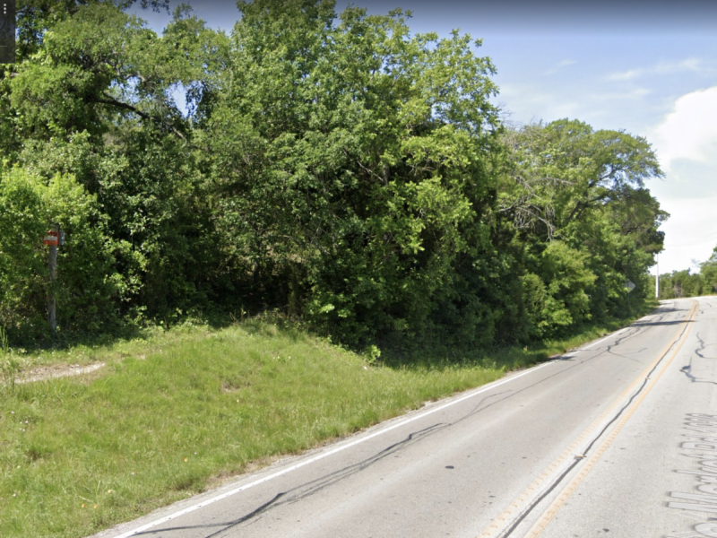
Is there a tougher climb? This one is really short. There's a longer one farther South by the water tower that's tougher IMO, but still not too bad.
That is the one. I have had four (I think) different conversations about adding a "B-Line" there.
Yes - it is rideable as is. It is even easier now that someone has created a gentler line around the ledge. How hard/easy it is to ride is your personal opinion. That may include how tired you are or how hot it is when you ride it.
No - there will never be a "B-Line" around it unless -->YOU<-- get TxDOT to move the road. If you don't like that spot - don't ride it. Walk it. Or ride a different trail. This trail is NOT the only way to get to other trails.
-
6
-
-
13 hours ago, Albert said:
That one is even easier as it's more gradual... 😄
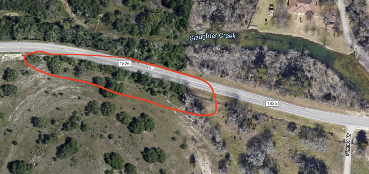
The one they are talking about is JUST south of the Slaughter Creek Trail driveway. The trail is hidden from the road by the trees on the south (east?) side of the road. When they built the road (1826 / Camp Ben McC) they 'flattened" the hill for the road. So the trail makes a pretty good climb with an off camber ~3' ledge almost to the top.
-
21 hours ago, CBaron said:
At 70mm?!? Oh boy I'm screwed...
-CJB
You are not screwed. Just do the "other" new thing. Wider handlebars.
You know five foot wide handlebars so you are stretched out and your weight is forward. 😉
-
I wonder if this makes a difference in suspension development - https://www.youtube.com/watch?v=tY3wT1_HrgI
Most of the suspension technologies trickle down from other places. Motorcycle motocross is some of the most directly applicable. And the riders are testing both of them.
-
1
-
-
10 hours ago, WatersPark said:
You can find project costs for previous Ncwt sections online here https://www.austintexas.gov/financeonline/account_services/solicitation/closed_solicitations.cfm
Search construction, Walnut Creek trail, NCWT, etc.
Here is the most recent
Note above where I said the "soft costs" (design and management) would be close to the "hard costs" (labor and materials to build the sidewalk). WatersPark links to why those costs are so high. It costs money to 'manage, report, comply with laws, and make transparent'. Note that I am pointing out reality. I am not complaining or blaming anyone. When the 'rules' are made to cover any project no matter the size, the costs of complying with those rules becomes a MAJOR percentage of smaller projects.
-
1
-
-
5 hours ago, AntonioGG said:
Oh yeah! Now it makes total sense. I should have looked at the google maps in addition to the other 2 maps. Next time I ride Windy I'll keep an eye out to see what that looks like. So under 35 also along the creek is what it seems like.
Would be cool if they'd let us get that trail going, keeping it rustic until they're ready. Is that something they'd ever consider?
Last question - no. I would not even waste time trying that one. Just getting to reroute the existing trail so it goes under the bridge they will have to build will take a minor miracle.
Location where the new sidewalk will cross under Lamar is well south of Windy Loop. It will be closer to the Main Creek Crossing than it will be to Windy Loop. Check the map in the PDF file.
-
6 hours ago, CBaron said:
So it takes $5 million dollars to create 1.7 miles of trail?!?
Did I forget to mention this was a government job????
Just off the top of my head -
I bet the design, permitting, oversight, etc. (everything except actually building sidewalk) will probably be about the same cost as actually building the sidewalk. But it might only be 80% instead of the full 100%.
The sidewalk is being built so trucks can drive on it. Including the bridges.
Just like the existing sidewalk, they have to build a temporary road big enough to bring in the sections of the bridges. Those are BIG bridge sections that require big trucks to haul them and big cranes to move them. Then they have to tear out the temporary 'road' they built and "restore" the area.
All of that cost money. Lots and lots of money.
-
After having done both a complete bike and custom build - I recommend doing the complete bike. The only reason I would do another custom build is to get some combination of components I could not get otherwise. When I have looked at the options, frequently it makes more sense to buy a complete bike and swap out the one or two components I didn't like. It usually came out cheaper than buying components until I got a full build.
Note - this is posted by a guy who still has a frame waiting to be built up. I bought it as a 'spare' for when my favorite aluminum frame fails. My frames (like AustinBike's) have a limited life. And that frame was no longer going to be made so they were closing them out cheap.
-
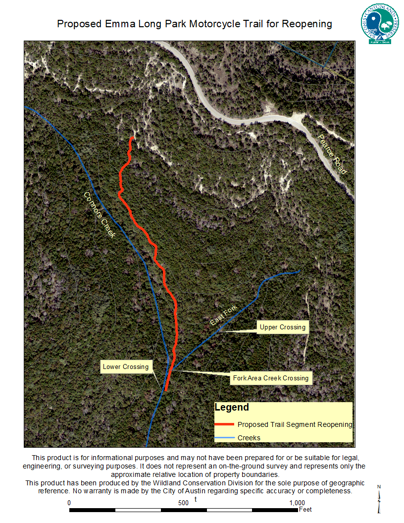
We have re-opened a trail at City Park. I doubt MTBR's know about or ever used this trail. So chances are good MTBR's will never find this trail or start using it. But it exists and is rideable now.
There is short bypass near the top of the Main Loop. This trail starts on that bypass and parallels the drainage channel until it hits where the fork of the drainage comes together. From there, there is a trail to the west that ties back into the Main Loop. This trail was EXTREMELY important to the motorcycle trials riders so they could get to their riding areas without doing the entire Main Loop. Since it was clearly outside of any critical water quality zone we were allowed to reopen it.
If MTBR's want to ride it - it is legal trail. Please stay on the trail and don't create bypasses or new trails. This is a two-way trail so be careful of on coming traffic. You should plan to yield to motorcycles regardless of who is up hill or down hill. You know they are there but they don't know you are there.
Attached are two maps. One an aerial view where the trail is located but it is hard to see the other trails. The other map has TONS on old information but shows the other trails. I 'circled' the re-opened trail in red so you can find it among all the info shown.

Ef LongMotorcyclePark-1996 Existing Trails - Shaded Sections - N-S Trail.pdf
-
2
-
-
Last week a group of us hiked the proposed route thru Walnut Creek Park from the current "end" of the big sidewalk to the east side of the park. There were several issues to bring to the group -
1) - PARD is saying NO NEW TRAILS. After the current section of the sidewalk replaced several of the exiting trails, we were allowed to replace those trails. PARD is saying that will not be allowed this time. The new sidewalk is planned to replace a long section of the existing trail that in my opinion, is not a high priority to Mtbr's. Most of that section is along Pool Lot Trail. (see attached map). I don't see that trail being a big loss to Mtbr's. Most riders on that trail are just getting to a 'real trail' to ride. I think we can share that part with the general public with out too much trouble.
2) - Charlie has proposed and flagged a parallel path to allow Mtbr's to bypass that section. PARD was adamant that that trail would never be allowed.
3) - The climb at 250 - 252 - 254 is likely to be closed. There were concerns about trails entering the sidewalk with blind entrances. Those trails are fall line trails that are eroding and exposing oak roots. My opinion is those trails should probably be closed but only if there are allowed to be replaced. If they are closed with no replacement - then keep them open. Sorry - an adamant edict gets an adamant response.
4) - The biggest problem is where the new sidewalk will cross Walnut Creek east of the Main Creek Crossing (see lower right red circle on the attached map). That is a highly used and popular trail. The City was proposing to build "board walk ramps" to allow Mtb's to cross the sidewalk at (roughly) right angles. The theory was that the climb on to the sidewalk level (I'm guessing 5 to 6 feet) would slow the bikes down to prevent collisions. I said that riders would get as much speed as possible to gap jump the concrete. I see potential for major collisions if they build these ramps. I suggested allowing the existing trail to be moved so the revised trail could go under the bridge that will be built over Walnut Creek. This would be similar to what was done at the bottom of Powerline Flow Trail. The engineer and PARD people did walk over and look at that area. There was NO commitment that this would be allowed. There was little commitment that it would even be considered. I think the folks were we talking with were afraid to make commitments that may not happen because they are overruled by higher ups. These were worker bees - not management that sits at a desk and issues edicts.
5) - There were a large number of trees with red survey tape around them. There was MUCH concern that the red survey tape meant the tree would be removed. We were told that the red marking meant the tree was surveyed - not that it would or would not be removed. Since some of these trees were HUGE old trees - several people walking the proposed sidewalk were relieved to hear these trees were not marked for removal.
6) - Overall - I think the big sidewalk is a good thing (I hate to call a concrete, ADA compliant structure a "trail". It is closer to a road than a trail.). This can be a place to ride when it is too wet to ride dirt. We can stay away from cars with drivers on their phones. Maybe, just maybe, we might be able to build new trail off the new sidewalk like at Brushy Creek. I support the big sidewalk even if it takes out some real trails at Walnut Creek.
That said, these are my opinions ONLY. I am about to hand this off to others. They may have different ideas on how to handle it.
You can see what the City has posted on their web site at the link below.
-
3
-
 2
2
-
-
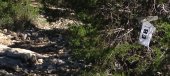
I a little bit familiar with the trails at Walnut Creek. I don't recognize where this was. I thought it was at the bottom of the "old" Powerline Downhill but that is across the creek from Point 6. My best guess is that it was near the entrance / exit of Point 6 since that is the only place that has a creek near Point 6 and the creek crossing like shown in his video.
This looks like old silt fence. It also looks like it could be at the edge of the park. I asked the original poster on Facebook to tell us where on the map.
-
3 hours ago, AustinBike said:
The biggest reason to want the Apple Watch is being able to actually read texts on the trail. Right now the Fitbit is unreadable so when I get a text I have to stop, open my pack and pull out my phone. Pain in the ass, but I need to stay connected most of the time.
I thought you were retired. Eventually, you will get over that 'stay connected' conundrum.
Just go ride. Your 'patients' will survive until you get back.
-
20 hours ago, AntonioGG said:
Don't some national parks already use the USNG?
This is the first I have seen of that. It shows (again) that none of us are as smart as all of us.
I should have asked the question of the "hive".
-
1
-
-
15 minutes ago, Albert said:
I need to make an effort to get down there more often for group rides, as that's the only way I'm really going to learn the trails.
For me, group rides don't help me learn the trail. I have to get lost, make wrong turns, back track etc. Otherwise I just follow the group and learn very little.
But other people may learn trails easier than I do.

Emma Long Trail Cutting
in Mountain Biking Discussion
Posted
Opps. I was ' not properly educated' on that. I went out and cleared face slappers and eye pokers in the limited time I had before the EB. I never got to Emma. Too little time.