
rugger
-
Posts
135 -
Joined
-
Last visited
-
Days Won
3
Content Type
Profiles
Forums
Gallery
Calendar
Posts posted by rugger
-
-
Thread resurrection - Regarding the Toro Grande Expansion I recently contacted City of CP works and they said there is no date planned to break ground for Toro Grande South is just conceptual and budgeted between 2023 and 2028, initial planning with no surveying even done yet. I am planning a new loop between Church and Deadwood and want to get at least a year out of it if I do the work. I am not expecting developers to start until the city builds the road extension.
Given that New Hope extension is well underway a betting man would say the North extension of Toro Grande will be first, especially give that the Indigo Ridge development area has expanded and rezoning to include houses along the New Hope area has recently been proposed.
Now, that said there is brand new survey marks on the derelict county road (178) between Toro Grande and Raley Road and the city crews recently cleaned up all the illegal dumping on other end of 178 by the Sanctuary - this latter part could have been advised by the Fire Dept/Forestry though in light of recent fires and that dumping could impede crews.
-
 1
1
-
 2
2
-
-
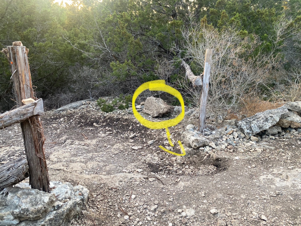
3 hours ago, WLemke said:
Wouldn’t the fact that someone moved it suggest that it was a feature and someone deemed it difficult enough?
Not really, it was completely optional and you'd actually have pretty much intentionally steer to it. . Plus, people are dumba$$es and do dumb shite all the time.
-
1 hour ago, WLemke said:
I posted this on the FB ATX MTB group and got about the level of discourse one can expect from FB…
Would anyone be willing to meet me out at brushy to replace this rock that was moved at the top entrance to Bob Ross. Despite what someone on FB said, this wasn’t an act of god. Assuming this wasn’t done by the Stewart or builder of the trail, Someone decided to sanitize the trail and it needs to be put back. It’s super heavy and I could use some help.
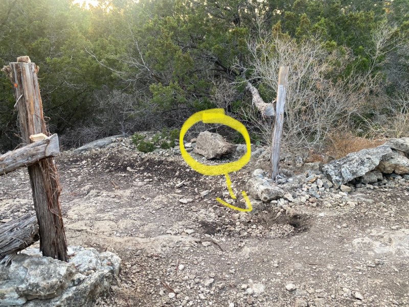
Repair the "divet" left behind would be my thought. that rock is not a gating feature, it's not a trail feature, its purpose is nil. In fact that fence post there would suggest that is the gate boundary and the rock is superfluous. The OG line that was there was way more challenging, so sanitization that was done to that area was sanctioned work...that rock doesn't represent a challenge.
Just my 2 cents. Now that I suggested that I imagine Ronan will put it back with concrete 😉
-
12 minutes ago, chuckt said:
I assume the preferred direction for this line is where that section is near the end... heading towards the gate?
I've been riding it more 'from' the gate lately.
I would say the preference is entirely up to you. I prefer the flow from the "bottom", which is by the gate. I simply think it flows better that way.
The new Hawg Bawg alt line IMO, flows well both directs, but slightly better from the "upper" entrance.
-
2
-
-
26 minutes ago, throet said:
Where is Hawg Jaw - part of the Snail complex?
Suburban Ninja trail system.
-
1
-
-
6 minutes ago, Albert said:
I'll get back out there this week, look forward to seeing it!
Enjoy!
2 hours ago, AntonioGG said:Wow! That alt line is awesome!
Glad to hear, not surprised 😉
-
1
-
-
Go ride Hawg Jaw, see what you think. There is an alternate line that will likely become the preferred line.
YW
-
2
-
-
My rant was a gripe and education. This is not a solution, this is a half-measure that IS potentially dangerous and costly. If these logs are placed without being secured they will (ARE) failing to stay put. The will become impalement hazardous - impaling people, wheels, and derailleurs, etc.
That said, no, I am not sabotaging this "work", I haven't touched this crap, except to roll over it.
-
2
-
-
On 8/25/2022 at 1:03 PM, GreenMTBrider said:
Heard SN is still too wet.
Yep, just a tad. We didn't walk everything, but we replaced the first and middle bridges, so at least you can access all the trails. The big span bridge added for the race series will need a while to be replaced, and the low water crossing on TLC is only a frame, no decking, but a decent MTBer can manage it. I imagine there will be a few more trees down along the trail, today our focus was on the bridges.
-
1
-
-
So the Chainless section - specifically before the Cradle was earmarked for significant rework - YEARS ago. Josh and I knew it was getting bad and would need work soon. Since I am no longer the steward and not planning to work out there... you can give feedback to Logan. There is some room for a slight reroute, but I think that eroded area could be "built up and armored". I thought it might also be a neat place for wood.
I've always thought a wood option at Truth or Dare would be cool too.
-
1
-
-
21 minutes ago, WLemke said:
What is the time stamp for “chainless” in the video? I’m really bad with the feature names.
Chainless isn't a feature, more of a sections of trail (an there is a subtitle "Chainless" - in the video and he's embedded it with the timestamp - so it should start on Chainless. The most notable portion is when it 90 downhill, off camber on a slab at the end. I assume the reference is riding it W to E (opposite of the video). Making that 90 uphill that is tough to ride...though the very top before the Cradle has always been tough. Hell, I built that shite I haven't have ridden all of DD in quite a while.
-
Yep. I manually "replicated" the new segment here in blue.
It's WAY too wet today - do not ride. I rode only the new segment since it was not exposed dirt at all yet. When SN is good to go, definitely ride the new trail - it needs wheels down. If you ride the boat trail, respect the blockage of the whopping 7 yards of "lost trail".


-
1
-
-
1 hour ago, Albert said:
I'd also like to know this, thanks!
Take a left before the "big hill" with the overlook (pretty much only one), The intersection has rocks in the shape of heart on the ground.
I start many of my ride ON that trail 😉 I cross the creek from the east when I ride from my house, this is basically my backyard.
-
Ninja is 100% NOT ready. Very wet out there. But hey, there is .5 miles NEW along the Boat trail as of 3:30 today.
-
Ravine Drop is super easy to just roll as well as drop. The day Josh and I cut it. Mar 2013, almost a year to the date from when Mike and I started building Deception. Interestingly, the guys (I think Jesse and Chad) flagged this without me...it was actually flagged to turn BEFORE the ravine. I came out and F this, we USE the ravine and so Josh and I cut it...that cedar in the ravine was a major obstacles.
I hate people...they stole Big Bones and Little Bones 😞
-
2
-
-
People concerned with RPR, just take an extra 5 minutes and go to the gun range bridge on Graphite Mine Rd and drop a water cache. That's what I do now, since I refuse to were a full backpack. My 2L will easily get me to the back of the trails to the quarry/gun range bridge area where I can refill.
30.79165100460675, -98.35612447015619
I REALLY miss the granite pool at the pavilion that was the BEST after riding an RPR. I can't even remember the last time I was there that it was functional/with water 😞
-
1
-
-
17 minutes ago, 2112Greg said:
Isn't the default way down SpongeBob just to huck it by staying right? That's what I always do...don't remember going down the cheese grater to the left. Definitely seems like more fun just to huck it...
Now, going up it, you have to take the cheese grater...it's one of the two things that sometimes prevents me from clearing 1/4. But with the right speed and gear, getting up isn't that hard. Just easy to get bounced and forced to dab.I always just launch straight down the middle and go up the same way. I have used the cheater line up, exactly once.
For me, the timing gets me, I tend to mash and bash vs being light and lifty. When I slow down and go lighter I tend to make it.
-
1
-
-
21 minutes ago, 2112Greg said:
Hey thanks, even a basic feature-name map would be cool and it looks like that's what you were posting but it's showing up with a circle with a minus sign in it. Not sure why that is, but maybe a missing file attachment?
I see the image fine on my PC.
-
8 minutes ago, trailrider77 said:
Are there plans to extend picnic x all the way to 183 and then to ymca? Seems like there is room
for more single track to be threaded along the creek.
Sent from my iPhone using TapatalkWe tried, it was off the table. Up to the current administration now. Wilco's default answer is always "No." Even adding Picnic XX to connect Picnic with Rim was a no-go.
-
11 minutes ago, throet said:
Is one of those two remaining drops shown in the pic called "Basket"? I go off of both of those routinely but have never figured out if they have names (not that I really care - just curious). By the way, big thanks to whoever cleared that low hanging branch beneath the exit on that first one (easternmost). I recall they even created a bit of a log roll from the cut lumber. Just noticed that this past weekend.
The 2 drops pictured to the west are still there, they have no individual names. Basket is at the very beginning of Upper Picnic (the only 2 way area of Upper Picnic). There is a carsonite post that even reads "Basket Drop". It's the perpendicular, not angled drop - most people roll it. Basket Drop is the first thing I hit in the video...and I ride it the correct way, dropping it. Excuse all the other bullshit in the video...I was in that experimental video phase.
Basket and both Upper Picnic Drops, as well of Big Ravine...
-
1
-
1
-
-
12 minutes ago, AntonioGG said:
Found the link. I had it bookmarked. Not sure it includes everything:
That's just trail names...Greg is wanting map with feature names.
NOTE: Josh's Caltopo includes planned, but not actual trails as well as closed stuff - Picnic XX, Secret Squirrel(rogue, but actual), Meg option, and of course Up and Over (aka 5.0) is closed.
-
1
-
-
Remember when BCB was going to add a 3rd drop...much bigger next to the 2 on Upper Picnic...oh yea, you don't because the bitch ass Wilco Steward destroyed it. The t-post would have been buried, road base and then dirt to top it off was the plan. Here's the skeleton we got started.
-
16 minutes ago, 2112Greg said:
I think I asked EB before, but I don't remember. I would love a map of the names of the features on DD. Does such a thing exist? I've cleared everything one direction or the other. The one that gives me fits is Squeeze Play, one of those drops is a cinch...the other direction, I just can't get lined up to bunny hop it...it's driving me nuts! Not too much trouble on the rest of it...I'm on a mission to no-dab DD.
The video on the BCB blog with the feature names is like 6 years old and if I watch it again, I'm going to have a seizure. Hope there's a map out there...is there one?This is the best I can do...I'd need to blow up Double Down to label everything in there and without pics, it'd be kind of pointless I think.
-
25 minutes ago, RedRider3141 said:
If any of you are skiers or snowboarders you know that little groms hitting features doesn't count.
True, they don't have far to fall, less gravitational pull and those rubbery bones help.


Brushy Creek
in Mountain Biking Discussion
Posted
"Billy Goat", and not "Old Goat" which was his actual nickname? Maybe another Wilco official's overreach, because "Old" would be ageist?
He was a great guy, was always willing to give a hand, and would give you the shirt off his back, so he definitely deserves recognition and is missed dearly.
Glad this old dream of a trail was finally realized.