
WhoAmI
-
Posts
281 -
Joined
-
Last visited
-
Days Won
6
Content Type
Profiles
Forums
Gallery
Calendar
Posts posted by WhoAmI
-
-
I love my Wahoo Elemnt Bolt for a few features:
- Upload a route from Ride With GPS and use turn-by-turn directions
- My SO can follow my rides
- Notifications if I want
- The screen layout is very customizable
- 15 hour run time
-
11 hours ago, Cafeend said:
This hole isn't a joke. It ate my 29" this evening. Could have been worse .. It was easy to see going toward Katy and avoid but on the way back from Katy , I was aware it was coming up but it still got me.
So, this trail is on the way to Houston?
-
 1
1
-
-
16 hours ago, GFisher said:
Please use pms. The vast majority of that is private property and/or unauthorized. And you can't ride far without crossing multiple property lines so no one person or entity has any real say. Treat it like you want it to be there in a year or 5 and maybe it will be.
He stated Bull creek, which is legal trail...nothing that needs a private message. If he is referring to off the map stuff, then his reply should be a PM.
-
4 hours ago, mack_turtle said:
I LOVE hiking at Bull Creek. I've tried to ride it a few times and ended up just carrying my bike through a lot of it. there's just no flow there that I could find. I enjoy a challenging trail, but Bull Creek is generally not rideable.
Can you pinpoint where this un-rideable trail is? I've been riding the Bull Creek greenbelt and surrounding trails since 1992 and would love to see some new-to-me trail!
-
 1
1
-
-
11 hours ago, AustinBike said:
A big goal is to survive 2020 so I wear a mask (bandana) any time I am out of the house.
-
18 hours ago, natas1321 said:
<snip>...looking farther down the trail when riding and not focusing on what's 20 feet in front of me.
Sent from my moto g(7) supra using Tapatalk
I've been riding mountain bikes for 28 years and still need improvement on this. I think I was better before I lost an eye in 2004, but now I should have no excuses. :-/
-
13 hours ago, AustinBike said:
And the Smith was replaced by a Bell Sixer. One ride, pretty uncomfortable. Wife said “what happened to your head” when I returned, two big grooves on my (big, bald) forehead.
Shit, done with Amazon, free returns is great, but this is a pain. Maybe I will mask up and check out some shops. REI was out of most stock in my size, maybe Pedler is next.
The Peddler in Cedar Park had a good selection last weekend. Bell, Smith, Kali.....can't remember the other brand.
-
1
-
-
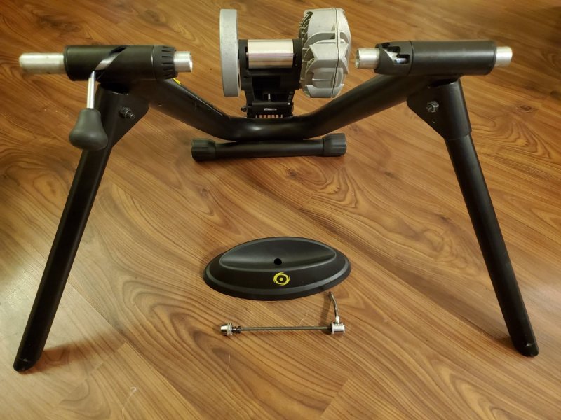
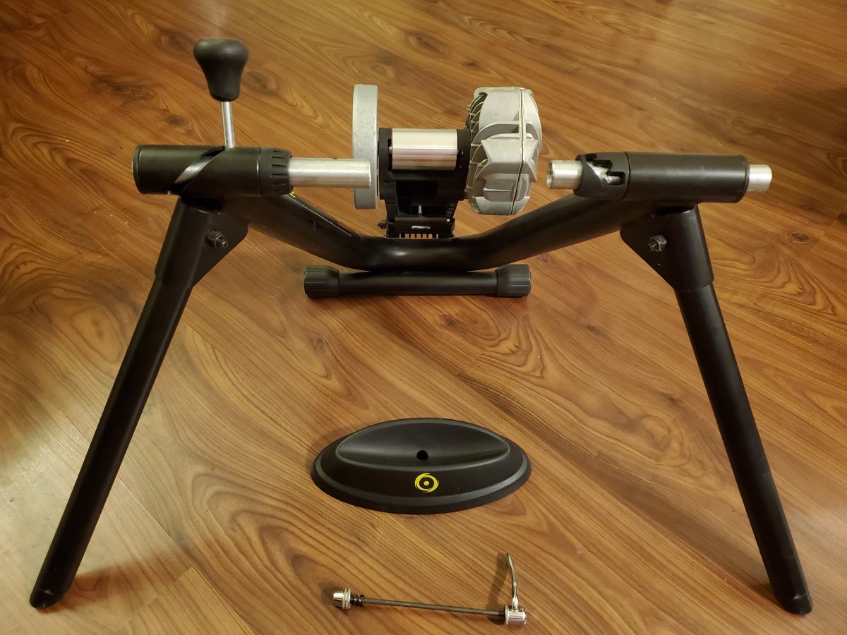
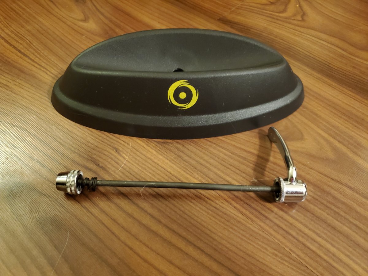
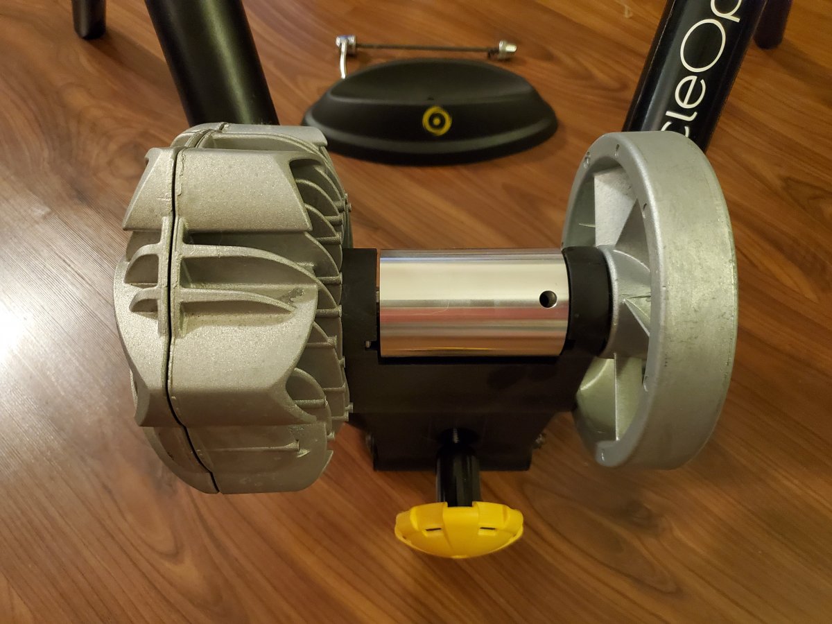
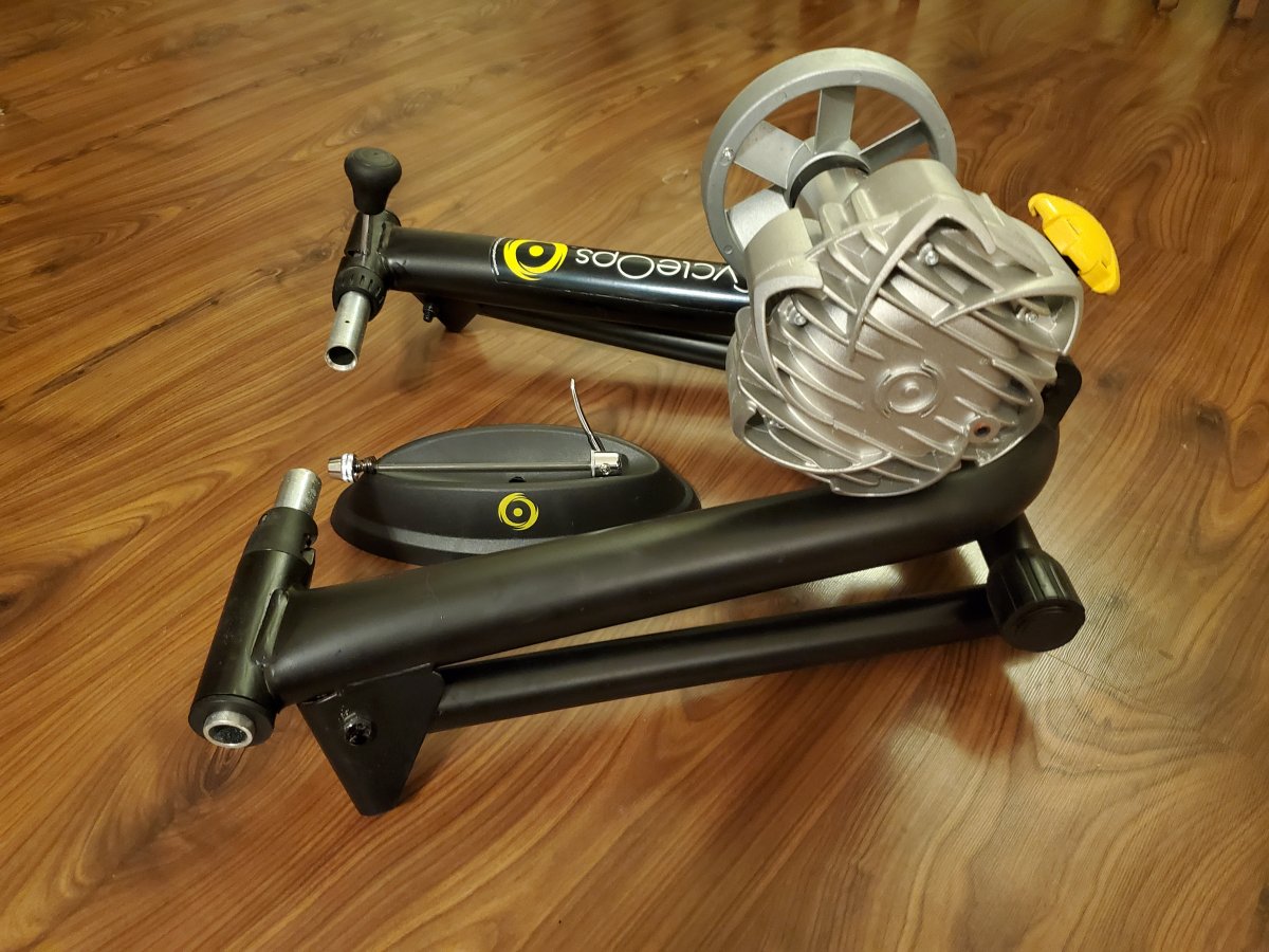
My wife has had this trainer for about three years and used it probably three times each winter since. You can see there is no wear on the roller and no scratches or chips on the frame. Includes the front tire block for a skinny tire and the training skewer for a road bike.
Text 512-797-RIDE.


-
3 hours ago, AustinBike said:
Yeah, my reading is pushing me towards making sure I have MIPS as well.
I think an even better option than MIPS is Bontrager's WaveCel technology. They don't quite vent like typical helmets, but it's not a typical helmet. "48X safer than traditional helmets"
-
1
-
-
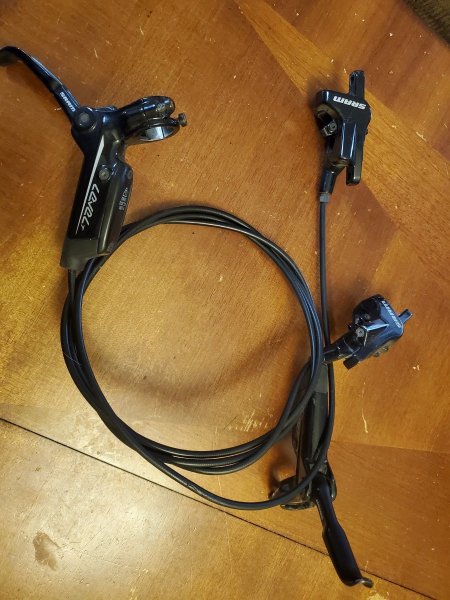
These brakes came on my wife's Tallboy and were under a recall I was unaware of at some point. So, they need the master cylinder replaced. The rear brake does not work, but the front brake was working when I took it off the bike.
The pads have a lot of use on them, too.
Text me at five12-797-RIDE.
-
6 hours ago, Taco Man said:
Try these guys
I second this recommendation. Top notch work. Quick turn around.
-
2 minutes ago, Teamsloan said:
No doubt, we should have more public lands, but I also have the admittedly optimistic view that I would rather private enterprise be the solution to problems than relying on the government to be the solution. Role of government type of stuff. And yeah, I realize how idealistic that value sounds as it's getting proven over an over to me how neither government or private enterprise gives a s*@! about me or any good will in general.
The thing about public lands in TX is that the government created the problem and society allowed it. For private enterprise to "be the solution," a private entity would have to purchase land to be used as a park and charge entry fees a la Disney World....or Flat Rock Ranch, which already had the land as ranch land and built trails for added value. After living and working in stated with great access to private lands (Co, ID, WI, GA,) I advocate for more public lands.
-
1
-
-
2 hours ago, Teamsloan said:
We need the central TX version of the Walton's. And/or some uber wealthy mountain bikers willing to throw significant money at acquiring land for the purposes of development...of bike trails. It'd be awesome if someone just bought all that land up and said, nope...only nature and trails here.
I'll go one further: We need more public lands in TX. 3-5% is not enough!
-
4
-
-
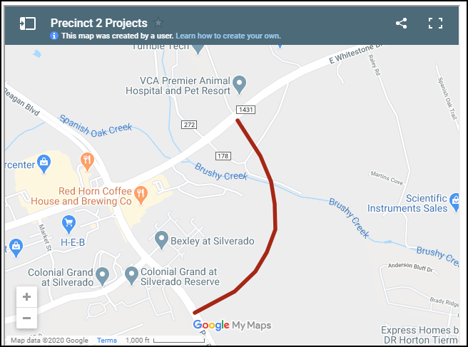
I saw this article on Community Impact, and it was the first time I saw the Toro Grande extension mentioned, so I googled more. This article from May 10 has an embedded map on which you can zoom in. I wonder how accurate the red line projection of the road is and where it will go in relation to the church. Add to this area the extension of the Brushy Creek Trail, and this area will see some significant changes, though the impact on SJ is mostly unknown.
-
I rode with a group Saturday from around 9.a.m to noon, doing about 18 miles from the YMCA to Ninja and back. Wasn't too hot for me, but I don;t mind the heat, and I ride with a 100 oz. CamelBak with a bladder half frozen water/half liquid water. Yesterday, my wife and I rode 22 road miles starting around 12:30 p.m. Same thing. It didn't bother me.
-
2
-
-
Park Closures
Following a sharp increase in the number of COVID-19 cases in Travis County, LCRA will close the five parks it manages in Travis County over the July 4 holiday weekend.
The following parks will be closed from 8 p.m. on Thursday, July 2, through 8 a.m. on Tuesday, July 7.
- Gloster Bend Recreation Area
- Jessica Hollis Park
- McGregor Preserve
- Muleshoe Bend Recreation Area
- Turkey Bend Recreation Area
The closures include boat ramps at the parks. Overnight reservations will be cancelled for a full refund.
All other LCRA-managed parks are expected to remain open over the weekend. Visitors must wear face coverings and should practice social distancing in the parks. No groups larger than five people are allowed, except for families or people living in the same household.
Parks operated by third-party vendors determine their own hours. Please call or check the park’s website before heading out.
-
FYI, the City of Austin is closing all parks, pools, and rec facilities for the holiday weekend and closing Barton Springs Pool and Deep Eddy Pool indefinitely.
-
Slaughter Creek is a good option b/c it's
- One direction for bikes, the other for hikers & horses
- A loop with an optional offshoot to lengthen it for a total of three miles
- No dogs
- Minimally rocky
It does stay closed longer than other trails when it's wet b/c its watershed protection land.
-
10 minutes ago, RidingAgain said:
So signage, continually restoring trails that have been altered, speaking about it on websites, speaking about it to people on the trails... None seem to be helping alleviate the problems.
The only solution I have seen consistently work is providing a bypass and posting a sign pointing to it "Feature Bypass -->". When I made bypasses for features, I made them slightly more inconvenient than the main line so the users bypassing the feature were not faster when they skipped the feature. If it's perceived as too long of a bypass, people will keep tearing down the feature. Also, I made sure that the lines of site for both the main trail and the bypass where they reconnected allowed for safe merging. YMMV
-
4
-
-
21 hours ago, Shinerider said:
Hmmmm. Most of my yard is dirt and grass won't grown anyway. Hmmm
Heheheheh - just got permission to put in some features! She did mention if I'm going to haul in dirt for a pump track - I better be bringing sod with it! But, she is cool with wooden stuff!
I've got a chain saw, hammers, and some galvanized nails, as well as a drill. I'm in!
Edit: Oh, and of course some experience building features.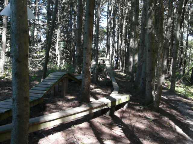
-
2
-
-
Just now, mack_turtle said:
I think it's Dekalb, the site is just a few miles west of Stone Mountain. Tucker?
Ah, I haven't ridden those trails then. I think the only trails I rode around there back in the day was at the Yellow River.
-
1 minute ago, mack_turtle said:
just for giggles, I used to ride these three trails near Atlanta.
Was that in Cobb County?
-
2 hours ago, HoneyBadger said:
Try riding it for more than five minutes...if you do you'll find there's multiple types of berms, rock gardens, jumps, wall rides, flat bridges, table top bridges, natural wood features, rollers, a flow section, drops, flat turns, insloped turns, creek crossings, hand-build sections, machine build sections etc. etc. I'd say it's not very repetitious...love to know another 3 mile section at Brushy that has as much variation?
I've ridden it all the way through; it's the epitome of trying to put too much trail into one area despite all the things you listed. Those things don't make up for what I don't like about it. And I'm not trying to put anyone's work down, either; I just don't like the trail. "It's not you; it's me." I know it's hard for builders to not take when someone dislikes their work personally. I've been there.
-
10 hours ago, FJsnoozer said:
The level of foliage and trees can affect how much trail you can fit in per acre. log loop is an excellent trail, that takes up a limited amount of acreage. Some property owners cram in a lot with a twisted design and it ends up with 5 miles of “point six” which gets old.
So, Peddler's Pass? I get bored on that trail after five minutes. Too repetitious for my taste, but I understand people like it. And, no, "just go faster" isn't the type of challenge I like.


Ride & Imbibe!
in Mountain Biking Discussion
Posted
The Legends are looking forward to your return!