

June Bug
-
Posts
1,071 -
Joined
-
Last visited
-
Days Won
40
Content Type
Profiles
Forums
Gallery
Calendar
Posts posted by June Bug
-
-
@AustinBike, check your DMs.
-
18 hours ago, TheX said:
That's...bizarre.
Yup, most peculiar! It's the mismatch that happens when different entities have different requirements and contractors.
-
 1
1
-
-
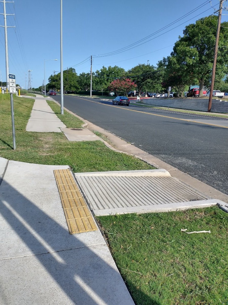
Yup, why add in the little section of sidewalk? This is where a side path from the Northern Walnut Multi-Use Path meets Park Bend Dr. That little curb-cut ramp goes...nowhere.

-
Update: There were two incidents on that morning. The person who crashed was pronounced dead at the scene. According to multiple posts on Facebook, the person who was transported for heat related issues also passed away.
We've done a few very early morning rides. The humidity at 7:30 am is wretched. As long as there's good cloud cover and even a slight breeze, it's marginally more bearable around 9 am.
-
2
-
-
The paved path. Will try to find out more in the days ahead.
-
2
-
-
"Paying it forward" working as intended. Helmet going to a good home!
-
I have a new in box Specialzed Comp helmet in size medium that I won at a Cranksgiving raffle. Free to a good mountain biking home.
Cinderella situation: It’s too big for me and too small for Mr. June Bug.
Specialized sizing for a medium: 21¼” - 23” circumference or 6 ¾ - 7 ¼ hat size.
Lyle Lovett "Dont touch my hat" lyrics:
So if you plead not guilty
I'll be the judge
We don't need no jury
To decide becauseI wear a seven
And you're out of order
'Cause I can tell from here
You're a seven and a quarterThe color is redwood. Redwood really really wants to be red, but it's on the almost red, but orange spectrum.
It also has ANGI, which apparently will call for help if you smack your head.
Here’s what AI says about ANGI: ANGi, or Angular and G-Force Indicator, is a patented sensor that can be mounted on a bike helmet to detect and track crashes. When paired with the Specialized Ride app, ANGi can act as a crash detector, ride tracker, and safety beacon. It measures the forces transmitted to the helmet during a crash, including rotational forces that occur when the helmet doesn't hit the ground. If ANGi detects a potentially dangerous impact, it can send a notification to the app, which can then alert emergency contacts and send their most recent GPS coordinates.
And this
ANGi can also trigger an alert on the user's smartphone, which they have a set amount of time to clear. If the alert isn't cleared in time, it will be sent to the contacts the user has set up. The standalone pod that contains ANGi connects to the app via Bluetooth Smart and uses a CR2032 coin cell battery that can last up to six months. ANGi is designed to work with almost any cycling helmet and doesn't add much weight to it.
I live south of Walnut Creek. If it works for you or someone you know, respond below and I'll DM you an address to pick it up.
On a totally unrelated note, I have about a bag's worth of bubble wrap (small and large bubbles) if anyone needs that. It does not bring me joy (Marie Kondo - if you know you know) and it needs to go.
-
Outside mag's thoughts about replacing PLB's with IPhone.
Satellite Texting Is Coming to the iPhone. Do I Still Need My inReach? Apple’s new iOS 18 update allows its products to work off-grid. But are phones a suitable replacement for purpose-built backcountry communication tools?
A top end IPhone may be in my future. I was in the middle-of-nowhere on the San Juan River in southeastern Utah in May. A woman in our group with an IPhone had enough coverage to call and chat with her husband. It was amazing considering that we were in a canyon.
-
COROS Dura review: Brilliant battery life
Just announced, the all-new COROS DURA is an impressive solar-powered GPS bike computer offering over 100 hours of battery life on a single charge, simple data and navigation functions, and an easy-to-use interface with a touchscreen and scroll wheel.
-
It's here! Well, coming in Fall 2024. Bikepacking.com: YOU’LL BE ABLE TO RECEIVE AND SEND TEXT MESSAGES VIA SATELLITE ON [Apple] IOS 18
"Yesterday in Cupertino, California, Apple introduced iOS 18, its latest iPhone/mobile operating system. With the new release comes a major upgrade to the Emergency SOS functionality that’s currently available on the latest iPhones. The enhancements include the ability to send and receive SMS and text messages via satellite without a Wi-Fi or cellular connection. This is great news for folks who typically rely on devices such as the Garmin inReach or SPOT for off-grid communication. Here’s the official statement from Apple:
“iOS 18 introduces Messages via satellite for the times when cellular and Wi-Fi connections aren’t available. Powered by the same groundbreaking technology as existing iPhone satellite capabilities, Messages via satellite automatically prompts users to connect to their nearest satellite right from the Messages app to send and receive texts, emoji, and Tapbacks over iMessage and SMS.3 With Dynamic Island, users always know when they are connected to a satellite. Because iMessage was built to protect user privacy, iMessages sent via satellite are end-to-end encrypted.”
-
Tuesday, June 11, 2024: Nice shower just happened in the WC neighborhood around 3:30 pm. Weather is unsettled and future radar looks like some nice t-storms later this afternoon and evening.
On the plus side, temps have dropped into the relatively tolerable range.
-
Non-mountain biking friends (in the 60 to 70 yr old range) who have done extended bike touring in Europe, New Zealand, Japan bought e-bikes this past year.
Their bikes are Specialied S-Works somethings, they swapped out the drop bars for flat bars and added 1.9" tires with a smooth rolling tread. They set it up so the battery is external and not inside the frame. This lets them pack the battery in a carry on when they fly with their bikes. At day's end, one can carry the battery inside a hotel room for charging.
We did a partly gravel (caliche!) road ride with them in the Round Mountain area a few weeks ago, and I picked up one of the bikes -- it's 30ish pounds, if that -- feather light.
They are in Spain/Portugal right now and reported that the bikes are doing great on some incredibly steep roads. They anticipate getting about 60 miles from one charge, depending on terrain.
Side note: Google "e-bike + solar panels". Lots of interest on the topic of charging e-bikes with solar panels for self-supported bike touring.
-
1
-
-
On 5/3/2024 at 1:52 PM, GFisher said:
Thanks, I was thinking of asking for any updates.
I'm a concerned that all of this rain has delayed things a bit.
-
On 6/11/2023 at 7:43 PM, Chongo Loco said:
It’s the Manor trail from that point to the RC airfield IIRC. Not quite sure where it will swing north, possibly further back in the field???
After crossing Johnny Morris, the current trail continues as a side walk along Daffan Lane. At Decker Lane, there's a pedestrian/cyclist-friendly crossing signal and the trail continues along past the upper reaches of Lake Walter E. Long, to the current end at Lindell Lane, where a caliche road turns off to Capital City Clays and the RC field.
The new section will parallel Lindell Lane for a little ways, cross Lindell Lane, and then continue to Manor. There isn't much left to do; hoping it's good to go by the end of June. The new trail is a little wider than the current trail.
-
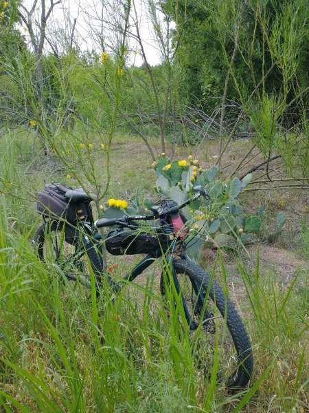
Nice ride to the city library on Amherst using the Northern Wanut Creek Multi-Use Path. This Palo Verde tree and prickly pear cactus in bloom were off to the side of the trail, so I decided to check them out. The cactus blossoms were pollen central for a variety of life forms. A butterfly, some type of wee beetle, unknown insect and some bees were in various blossoms, all covered in pollen. I didn't notice the butterfly at first. It's the same color as the petals and wasn't moving much. I was there for about five minutes, and the butterfly and two other wee creatures were still working the pollen in that one flower.

-
6
-
-
-
Just realized this should be in the e-bike thread. Carry on.
-
1
-
-
The point of the NPR piece is that mining for the types of raw materials needed to make batteries can and does have adverse/detrimental impacts, and those impacts are borne on the backs of poor/powerless people in places where there are zero regulatory processes to protect humans and environment and that those impacts are invisible to end users in countries like the US.
-
5 hours ago, AustinBike said:
But what the industry needs is some standardization. That will drive adoption faster than anything. Additionally, while it is not optimal, if you had a removable battery you could actually carry a spare with you on an overnight trip if you needed to. Sure, its not optimal because of the weight, but it would be a consideration.
This is such a good point. I went to the Trek website and read about the Marlin. Battery life is only 2 - 4 hours, depending, which is hugely suboptimal. Of course, the power option would be for climbing only, but still. The Marlin battery is not removable. Trek will have an additional battery option:
"When you want to pedal farther, partner your Marlin+ with a 250 watt-hour Bosch PowerMore range extender battery (sold separately) to increase range by over 60%. (Coming soon!)" That battery mounts on the down tube and just plugs in.
Fortunately, there are a lot of websites comparing various e-bikes, battery life, weight, and all the things.
Things will be moving along in the ebike bike packing world when the e bike battery can be charged with a small solar panel. Someone has done it already: HERE This is Scandanavia; a hot Texas sun or clear sky in the desert Southwest might work faster.
-
Listened to an interestig piece on NPR discussing the shift to battery-powered cars and the price paid by the people who live where the raw materials are mined and the ecological impact of mining those materials vs the impression that battery power is completely green and clean.
But, I digress. These last few weeks, I've really started looking at e-bikes, knowing one is in my future. Advancing age + difficulty in recovering due to some health issues + plus the side effects of medication for those health issues -- I'm there. My main concern is how long a ride will a battery support because I'd like to use one for short, overnight bikepacking trips that would likely be on two-track or bladed roads with no options to stock up on water. Yup, we're talking SE Utah and SW Colorado.
Thanks for the TREK Marlin link, it looks like a possibility, but I'll be looking around. A few weeks ago I did find a website on hardtail e-bikes, comparing battery storage capacity.
-
2
-
-
On 2/22/2024 at 12:42 PM, Ridenfool said:
Recently had that conversation about not pushing limits with some friends.
Had a bit of a learning experience this past late summer/fall. We were riding Boggy Draw above Dolores, CO two or three times a week at 8,000' elevation. Mostly non technical, buff singletrack, but the beginning of the loop that we do is a gentle climb for about 3 miles, with a steeper grade towards the end of the climb.
I finally realized that I could just get in my easiest gear and easy spin right along keeping a steady cadence rather than working at pedalling hard. That's when I started to be able to do the whole thing without stopping. Definitely more fun, easier on the legs and I think better for cardio.
-
2
-
-
Rode Outer Log Loop at Walnut Creek Sunday evening and heard two great horned owls hooty hooting at each other, probably from some of the tall cottonwoods down by the creek.
According to this video, I was hearing two males. The female call is completely different.
-
On 9/17/2023 at 5:48 PM, June Bug said:
Motorola Defy is available and the reports are not good. The consensus is that it was released too soon, without sufficient testing and tech support is, "Try this. It might work. No? OK, how about this?"
Heh, reports are worse now that the company that was making the Defy device has died.
Bullitt, the rugged manufacturer behind CAT and Motorola smartphones, is no more
"Bullitt, the manufacturer of rugged phones, has closed down due to intense competition in the smartphone market. The company had ambitious plans for satellite-based text messaging, but the deal to transfer the satellite-focused portion of its company fell through."
-
Yup, COSTCO has a carbon fiber Intense 951, 150/140 trail/enduro bike, WITH WATER BOTTLE!!!!!
- Premium Carbon Fiber Frame
- Fox Suspension, 150/140mm Travel
- SRAM 12-Speed Gearing for Easy Climbing
- Adjustable Dropper Post
- Pedals, Water Bottle and Toolkit Included
- 33 lbs
Oneline Price $2,999
Less $1,000
Your price $1,999 (until March 3)
Shipping and handling included!
No specifics on the components, I assume basic SRAM, Fox
They also have an Intense gravel bike and a full suspension carbon XC bike.
-
1


Entry Level Full Suspension
in Mountain Biking Discussion
Posted · Edited by June Bug
Sorry, was trying out a link that didn't work!