cxagent
-
Posts
609 -
Joined
-
Last visited
-
Days Won
28
Content Type
Profiles
Forums
Gallery
Calendar
Everything posted by cxagent
-
I call BS on that. Even PARD used some of what Austin Bike said on their web site. But they changed it just enough to not get sued for copyright infringement. Oh, wait. I copied that from the AB site and modified it because PARD said they needed something to indicate the trail was not beginner friendly.
-
Since you want to use the Root Drop at Walnut as an example, you should have a little history to go with it. First, the Root Drop has been "fixed" repeatedly. Many people have tried to correct the erosion problem by armoring or otherwise reinforcing what remains of the fall line trail there. The next time the creek floods, all that work is gone. Being a fall line trail in the outside corner of a flood prone creek means to me - that trail will never be corrected. The only "correction" would be to close and move that section of trail. People piss and moan about closing any trail. And you should hear some of the bikers, hikers and dog walkers SCREAMING about us F'ing up their park. Second, The land manager for Walnut Creek has said there will be ZERO net new trail. You want a bypass - what are you going to close to offset the increase in trail? We have worked within that direction when we lost the trails that are now side walk. We have added more fun trails (Power Line Flow, Ski Hill Flow, etc) in exchange for closing trails the land manager wanted closed like the old Power Line and Ski Hill trails. We worked a miracle (IMHO) to reconnect Inner Log Loops so it was not a dead end back to the side walk. The only way that happened was because the Land Manager and Forestry recognized what we had done for them so they were willing to work with us for solutions. I am not willing to poison those relations by building a bypass that is not authorized. Want a sign that warns people what is ahead? It is in the works. Should have been done already. But silly me I prioritized paying work (LCRA) and keeping trails open (BCP) ahead of marking a trail that most people know and avoid or ride intentionally. I have to admit, I also prioritized building new trail as soon as we got authorization so that authorization didn't get yanked (Williamson Creek, Country Club Creek, Guerrero Park, etc etc. etc.) I take the blame for not having that sign installed already. If only I was independently wealthy and didn't have to earn a living. Many people, like my wife, gladly ride a trail that suits their ability and walk the portions that are too difficult. As long as she / they ride more than they walk they are OK with it. I guess you are in the minority that thinks they should be able to ride everything on a trail or the trail needs to change. Oh, wait, were you at Pace Bend recently??!??!
-
Since signs don't seem to be the answer, maybe posting on the internet so people will have some idea of what to expect - PARD posting - http://www.austintexas.gov/sites/default/files/files/Parks/Planning_and_Development/Description_of_Emma_Long_Motorcycle_and_Mountain_Biking_Trail.pdf Austin Bike posting - http://www.austinbike.com/index.php/austin/6-citypark Trailforks posting - https://www.trailforks.com/trails/emma-long-mx-park/ I bet MTBProject and others have similar warnings. You can't please everyone no matter how hard you try or what you do. Somebody will bitch and complain if you gave them a $100 bill. As long as it is just talk or posting on the net - fine. That is their opinion. When they starting cutting trees - I start ranting. And I don't just complain and not do anything about it. 😉
-
Does anybody remember a sign at City Park that pointed to the ~8 foot climb/jump at the east end of the parking lot? That sign said something like - "If you can't climb this, you will not enjoy this trail". That sign has been gone for years now. But even when it was there, people who were bound to get in trouble tried to ride that trail. And they got hurt. Repeatedly. And there were calls to close the trail because it was "too dangerous". So why is it "too dangerous" for some and "a walk in the park" for others? How do you warn people who might get in trouble? Maybe a sign??? A sign that was torn down years ago because it was "not appropriate". Hmm, I thought it was clear and to the point so that people might actually read it and pay attention. That sign was replaced by a PARD sign not far from that same spot. Has anybody read it? It is only about 10 lines of text. Can anybody tell me what that sign says? Even ONE line of what that sign says???? How effective is that sign? It might be "appropriate" but I would say it is not effective. How about the signs on the Gates of Mordor? Anybody remember those those signs? They were short and to the point. I could go on about similar signs near Everwet and how they "disappear" and "don't appear to be effective". And don't forget that there are only certain places signs of ANY sort will be allowed. Kind of like alternate lines. Great where they can be placed but not a universal solution. Using City Park as an example again - there is not a single bypass that is recognized. And most existing bypasses are supposed / planned to be closed.
-
Signs at the parking lot and on the trail are being done. If you happen to have seen what is done on the LCRA signage project (McKinney Roughs, Grelle, and Shaffer Bend) we have been putting green / blue / black trail ratings per the IMBA guidelines. If you have been to Muleshoe in the past year, you might have noticed that those same signs point to two new "Bypass or B-line" that we have created so the entire main loop can be rated green. We need to get back to finish the other three but other issues have taken priority. NOTE - we have not closed or sanitized the five technical spots on the main loop - only created longer/slower bypasses. If you can ride the technical spots you have a speed advantage. If you take the bypass it is easier but takes more time. I think that is a win - win for everybody. Lower skills have a rideable route. Higher skills have a speed advantage. Hopefully nobody feels like they have to screw up the "other line". Also note that not every trail or feature CAN have a bypass. Sometimes the terrain just does not allow it. Sometimes the land owner/manager will not allow it. Some people should stay off trails they don't like or can't handle. But those same people are the ones that claim that the trail has to be "cleared" so they can push their baby stroller on it. Yes - I got that exact complaint on the BCGB. Part of the reason the tree cutting gets to me is the number of times I have been told I am "ruining trails" or "building wheel chair ramps". And when there is a technical trail feature some asshat screws it up. Entitled people appear to me to be the problem. ENTITLED people. The solution I see is INFORMED/EDUCATED people. That is the reason I am positing this. I hope that people on this and other boards can help educate people.
-

Texas Parks are Being Loved to Death
cxagent replied to mack_turtle's topic in Mountain Biking Discussion
More info. I have not verified all of this on either side. However, I think Texas needs to stop raiding parks budget and properly fund parks. Parks Advocates Recruitment Letter-FINAL.PDF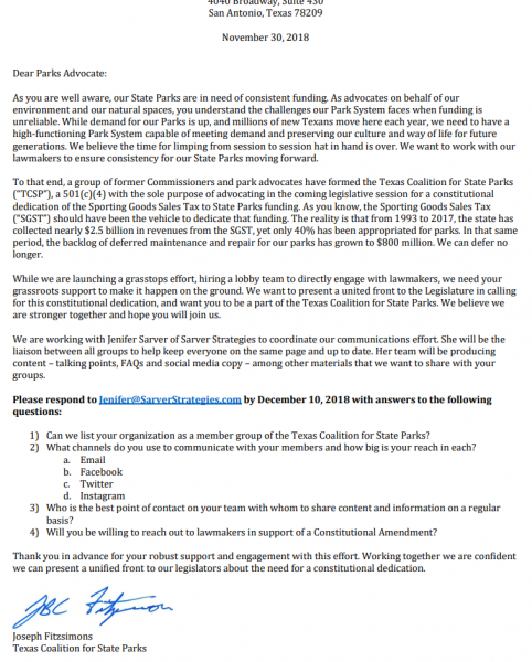
-
Texas Parks are Being Loved to Death
cxagent replied to mack_turtle's topic in Mountain Biking Discussion
In reading this thread and the links, I am stuck by the confusion. It appears to me that the confusion was not an accident. ARR was recently approached to support a lobbying effort to get the sporting goods tax money dedicated to parks. The legislature keeps raiding that money for anything/everything but parks. -
Texas Parks are Being Loved to Death
cxagent replied to mack_turtle's topic in Mountain Biking Discussion
I think this should read - "Austin created more public land in the the last 20 years than either the state of federal governments. In fact, Texas leads the nation in local ballot initiatives to invest money in green space and lands the public cannot use." The Balcones Canyonlands Preserve and the City of Austin Water Quality Protection Lands both qualify as 'local ballot initiatives that created public lands' and they should be considered 'green space'. But parks??? Not hardly. There is some very limited change in how the public is allowed to use that land. But most are fenced off and marked "No Trespassing". After dealing in a much more positive way with the BCP and WQPL, I have a better understanding of why the lands are fenced and the public kept out. I don't like it, but I understand it better. We might get more access in the future, but it will always be limited access. And it will take a lot of volunteer time and effort. -
There has been a "B-line" for years (smooth down and up to the left). There has been a "C-line" for years (stay right of the tree). If somebody wanted an "easier route choice" it was already there. What they did was to take away the harder line. I cannot think of any reasonable justification for what they did.
-
I was riding Pace Bend today. There was a place on Wookie Way where you had to ride a skinny rock ledge past a little tree or drop down to your left and ride a smooth path. Someone took it on themselves to cut the roots of the tree and push the tree over. Now it might as well be a paved road thru there. Oh wait, the rocks are a bit loose and bumpy. Maybe they can bring in some concrete and make a sidewalk thru there. This spot usually had three lines A ) the skinny past the tree B ) drop to the smooth path to the left and climb back up C ) most of the time you could go around the tree to the right (was usually blocked during events so riders had to use some actual skill). I am thinking about replacing that tree with an 8 inch steel pipe filled with concrete. Just because you can't ride it does not mean other people can't ride it. Bring your skill level up to the trail. Don't bring the trail down to your skills. Over time, even you might learn to ride with more skill. Asshat. I know what I'm going to hear back - "The person who did that is not on this board." Maybe they are not. But it seems everybody needs a reminder. "It's public property so I can do anything I want." BS Ask the two guys that were charged with felonies for cutting down trees to build a trail on a national park. Some of us spend many many many hours working with the land manager to get agreement on what can be done. This kind of tree cutting poisons all those hours of work. "It was too dangerous like it was. I just made the trail safer." BS You could ALWAYS go around. There was already a B-line. You decided the few seconds on your Strava time was more important.
-
Wondering if the LCRA problem has been solved. I am pretty sure there is no building permit required in that area. The only two things I can think LCRA would complain about are 1) they think it is a power line or 2) it crossed an LCRA easement. I would think anybody putting that much money into the project would have already covered both of those issues. OK - one more issue. If the LCRA did not think they had capacity to supply all the electrical power needed. Spider Mountain could install their own motor generator sets. Could be done but it would cost a lot of money.
-
The merino wool (Smart wool) layers can take a lot of sweat / moisture and still be fine. Unless they get soaked, they wick the moisture away from my skin and still keep me warm. Just a comment on wool insulation - put a breathable shell over it and never take it off until you are done. I can usually unzip my jacket a little if I start to get too warm and keep going. I have never been able to wear "heavy gloves" and still use the brake. Even back in the dirt bike days I was bare handed because I couldn't use the front brake when I needed it. On a motocross bike, I needed it even more. So I also put a beanie cap or a balaclava on to stay warm. It is frequently one of the first things that comes off. Fortunately, it is a quick easy task to take off helmet, take off hat, put helmet on, put hat away. I don't get cold in that operation and want it back on.
-
What works for one person may not work for someone else. I had to try a lit of different things before I found something that worked for me. I have arm warmers and leg warmers. I tuck the tops well inside my normal cycling shorts. They work fine when it is cool to slightly cold depending on what / how hard I am riding. Make sure the leg warmers are sized right for YOU. As they wear or you lose weight they may not work anymore. I am convinced leg warmers without a zipper were invented by a sadist. If I am warm enough to want to take the leg warmers off, I have to stop and take off my shoes to get the zipperless leg warmers off. By the time I get everything off and start riding again - I am freezing and want the leg warmers again. With zippers at the bottom of the leg warmers, I can stop quickly and slide the leg warmers off over my shoes. That way I am riding again before I am too cold. For the next level of cold weather (estimated 45F down to 35F), I have some "tights" I pull on over my regular shorts. Mine have enough elastic in the ankles that I can pull them off over my shoes. I don't remember a time when I started riding with these and wanted to take them off during the ride - but I could. For the next level of cold (estimated 35F to 10F), I have "neoprene-like" bibs I put on over my shorts. I rode snow bikes in these and was fine. I don't think I want to ride in weather any colder than 10F. Note there are layers and other 'tricks' for keeping other parts of my body warm. Having snow ski gear to pick from helps. (Ski socks, different weight base layers, smart wool vests and jackets, etc.) I also have neoprene shoe covers so I can wear my regular shoes. On the snow bike I wore water resistant hiking boots with flat pedals. On any other bike I wear the same vented Sidi shoes I wear year round. Everybody is different - but I will resort to a plastic bag only under the wettest or most extreme cold conditions. In snow skiing, anything that gets wet with sweat is cold. Miserably cold. Plastic bags don't breath so all moisture is trapped and things get wet like you have sweated like crazy. Your experience may be different. But I have stopped in the middle of a long bump run to take off a wet layer. That means I stripped down to bare skin on the side of the mountain to get rid of the sweaty base layer. And I was more comfortable afterward for doing it.
-
I agree with the recommendation that it is time for a new shock or a major rebuild. However, it you really want to keep using this shock at minimal cost - Bike shops that do shock work will have the means to recharge your shock with nitrogen. The cost should be much less than having them rebuild the shock. Everybody that does air conditioning work has a nitrogen tank and regulator. You might have to spring for some adapters to get their existing parts to a Schrader chuck that would fill your shock. But many of those folks have already addressed that for their mountain bike or dirt bike suspension.
-
Best Place to ride after a rain storm?
cxagent replied to ecoastjohn's topic in Mountain Biking Discussion
If you go on Sunday, please let us know what you found. You might even tell us how your drive train held up after you get back a ride once or twice after a wet RPR ride. Everybody has a different level of "tolerance" for conditions. Some people don't mind heat. Some people can't bear heat. Some people don't mind cold. Some people can't bear cold. Some people don't mind wet trail. Some people even enjoy wet trail. At least at RPR riding wet trail does not damage the trail much. -
New BCP Public Access Land Management Plan Released
cxagent replied to cxagent's topic in Mountain Biking Discussion
Probably the last update before the meeting - I will be there. I speak in support of the revised plan. The major issues have been worked out. It is not a perfect document but I think it is fair. I will thank the BCP staff for all of their work. This is a working relationship I hoped for but thought would never happen. It is a Christmas miracle. I invite anyone and everyone to come to the meeting. But it is not anywhere near as important to have a large number of supporters/speakers as it is when we are opposing something. Come on down if you have something to say or just want to watch. But don't cancel other plans or take vacation time for this meeting. We might need you at a later meeting. -
New BCP Public Access Land Management Plan Released
cxagent replied to cxagent's topic in Mountain Biking Discussion
I don't have time right now for a real answer but here is a very quick answer. What "we" stakeholders / park / trail users want and think we have reached is a public access plan that is fair, balanced and a reasonable compromise to all of the parties. Without beating a dead horse again, past history makes some of us feel that fair or even compromise were not possible in the past. Does that mean the negotiations created a perfect plan that will solve all the problems? Not even close. But it creates a frame work that all sides can be represented and their views considered based on data / documentation. The Tier II plan (this one) is a high level plan that does not address details. So a framework is all that can be expected in this plan. There will be negotiation / compromise / loss / gain / etc as the details are worked out in the Tier III plans (site by site, trail by trail). My hope is the fair, respectful, transparent working relation that has been developed will carry forward. For this group, I have to expect that we will lose some trail that will cause major heartburn. Some are trails I want to ride forever. Keep in mind that there is a legal framework over and above anything in the BCP. Even if 'it has been done before / for decades', there may be good reason why it should not continue. I hope we can gain some too. I have reason to believe that we may actually gain some. Data posted above is but one reason I have that hope. The efforts of the BCP staff is another. -
Best Place to ride after a rain storm?
cxagent replied to ecoastjohn's topic in Mountain Biking Discussion
Urban ride Veggie Buffet (EB with out the trails) Trainer Pedal Hard I might be wrong but the forecast makes it sound like they are expecting at least 3 inches of rain maybe as much as 6 inches. I doubt even RPR would be tolerable with that much rain that is forecast to end sometime Saturday. -
New BCP Public Access Land Management Plan Released
cxagent replied to cxagent's topic in Mountain Biking Discussion
A recent development. late yesterday BCP staff provided trail maps from the 1999 Tier III plans that we could not find. I suggest adding a sentence to the current revision that says that if no map is shown in the currently adopted Tier III plan, then the trail map from the most recently adopted Tier III plan defines the authorized trails. That give us a starting point. Let's hope the BCP staff will accept that or suggest something like it. As noted above, I was down to four make or break issues. It looks like we might have solutions to all four. If solutions are found to all four issues, I would recommend the approving the revised plan. There are a lot of things that can still go wrong but this is the best I have seen this process work. I have to thank BCP staff again for working so hard to find solutions and make corrections. Late breaking news - It looks like BCP staff agrees and will be recommending the changes we requested. Keep your fingers crossed!!! -
New BCP Public Access Land Management Plan Released
cxagent replied to cxagent's topic in Mountain Biking Discussion
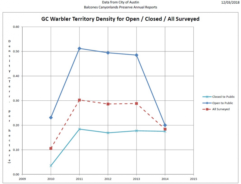
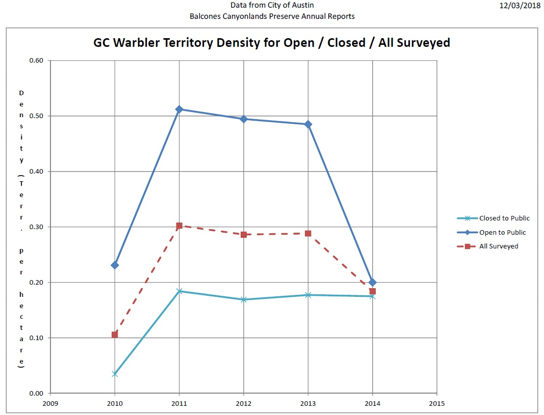
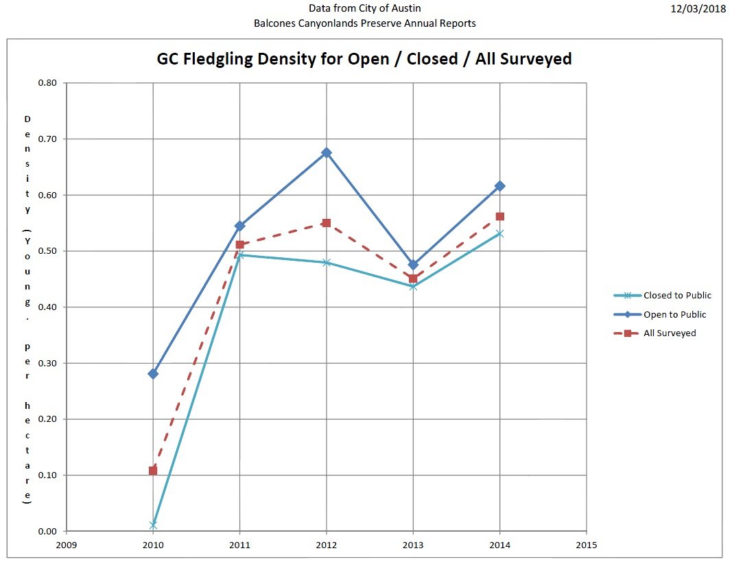
Territories are where the warbler "claim an area" as their own. A warbler seen somewhere might be 'passing thru' (not a territory) versus has claimed an area (territory). That is not a perfect definition but it is my quick top of my head description. So higher territory density means there are more warbler in an area. Approx twice as high territory density like shown in the graph means there are twice as many warbler in an area. So the 'open to the public' in the graph above shows the warbler are approx twice as numerous in areas open to the public compared to areas closed to the public. Fledgling density is the number of baby birds (fledglings) in an area. So the graph above shows there are more baby birds per unit area on open tracts than on closed tracts. -
New BCP Public Access Land Management Plan Released
cxagent replied to cxagent's topic in Mountain Biking Discussion
You can find backup documentation including the current version of the public access land management plan at - http://austintexas.gov/cityclerk/boards_commissions/meetings/76_1.htm I hope some people can be there to speak. I will be there. If you can be there but don't want to speak - please donate your 3 minutes to me or someone else. -
New BCP Public Access Land Management Plan Released
cxagent replied to cxagent's topic in Mountain Biking Discussion
I keep wanting to add specific details on my recommendation to request approval or rejection of the revised Public Access Land Management Plan on Friday. I cannot make that specific recommendation - still. BCP staff is still working with us to try to get final issues resolved. Let me point out that this is the absolute best working relationship we have had with BCP staff. They are trying really, really hard to get issues corrected. I cannot thank them enough for their efforts. The original 1999 public access document was written from a stand point of ' we don't know what impact public access has so we have to err on the side of the species'. I agree with that stand point in 1999. In 2007 when this same document came up for revision and update, that stand point was not nearly as valid. At that time we had a lot more data and knowledge about the impact of public access. The BCCP Coordinating Committee rejected that revision and instead voted on a policy statement in 2007 that said the BCP was an endangered species preserve first and foremost, but where possible public access should be permitted under carefully controlled and monitored conditions. I agree with that stand point as well. In 2017 the revision presented may not have been intended to, but it had a strong appearance that it was written to further restrict public access from even the 1999 version. It was never brought up for a vote due to all the comments from the public. This 2018 revision started with the same appearance as the 2017 revision, but watered down slightly. Or maybe it was better explained in the original 2018 revision versus the 2017 revision. Since it was released on October, the 2018 revision has gone thru substantial review and revision with many stakeholder groups. I want to give BCP staff credit again - this was not done in 2017 and the lack of review contributed to the appearance that it was intended to further restrict public access. In my opinion, we are down to two issues - The current revision says that 'authorized trails are shown in Tier III plans' (Tier III plans as the specific tract by tract plans. e.g. Barton Creek Greenbelt, Emma Long, Bull Creek, St Ed's, etc.) The problem is that we cannot find any Tier III plan of any year that shows authorized trails with the single exception of the 1999 plan for Emma Long Park. One interpretation of pointing to non-existent maps is that no trail is authorized. Another interpretation is that 'we are still working on those and we will show them to you when we are done'. I don't consider either of those interpretation acceptable. The BCP staff response to the comment is that the 2007 Tier III plan shows the 1999 maps as "background information". "Background information" is not the same as "incorporated by reference" or better yet - copy the map into the 2007 plan. But we don't find any maps in the 1999 plans except for Emma Long. That response make me even more suspicious. This issue is a major concern. The other issue is that 'flavor' throughout the current Tier II public access plan that 'public access is detrimental'. I looked for one place to correct this instead of a complete rewrite to remove that flavor everywhere. I suggested adding a sentence that 'data showing a positive impact to the species should not be ignored'. Staff is rewriting my comment to be a positive statement instead of a negative statement and trying to get management approval. I agree with rewording my suggestion as long as there is something that indicates that not all public use is detrimental to the endangered species. As shown above, the BCP's own data indicates that public use of the preserve may not be all bad. It may not be perfect but at least it shown in the public access land management plan that locking the public out of the preserve is not a solution. The rest of the issues/comments have been worked out to the point I can recommend approval of this revision. At this point I am planning to attend the Coordinating Committee meeting this Friday and commenting. If these issues can be worked out, I would recommend approval of the revised plan. If the issues have not been worked out I recommend postponing the approval vote and continuing to work on them until corrections are made. If the choice is only approve or reject today - I have to recommend rejection until corrections are made. These two issues are deal killers. No matter which way it goes, I plan to speak in glowing, positive terms about all the work BCP staff has put in to work out issues and try to find win / win compromises. They have really worked thru a lot of major and very contentious issues to get down to just these two remaining issues. -
New BCP Public Access Land Management Plan Released
cxagent replied to cxagent's topic in Mountain Biking Discussion
CBaron - your comments are correct. I would add that since the 'open to the public' tracts are better than 'closed to the public tracts' everywhere and in every year - the BCP's own data says that to improve the numbers and productivity of the warbler they should open more areas to the public. They were forced to develop a plan to do just that. It is called the BCP Trails Master Plan which can be found here - https://austintexas.gov/sites/default/files/files/Water/Wildlands/BCP/bcptrailmasterplan.pdf It is interesting to note that the roughly 2 times difference of the territory density is HUGE. That is clearly not a "statistical anomaly". These charts were developed based on a report written by the BCCP Scientific Advisory Committee back in the 1990's. It was appendix C of the October 2018 draft revision of the document up for approval on 12/7/2018. There is a link to it in the first post of this thread. The report said that to address the impact of public access on the Golden-cheeked Warbler, these two parameters needed to be reviewed over a five year period. Here is their own data showing the parameters they said were important over the period they said was needed. Now I wonder what "logic" will be used to say that we don't understand. -
New BCP Public Access Land Management Plan Released
cxagent replied to cxagent's topic in Mountain Biking Discussion
With large bureaucratic organizations (government), everyone can say no. But it just about takes a miracle to get a yes. If there is an agreement, then it goes up another level where the process starts over again. -
New BCP Public Access Land Management Plan Released
cxagent replied to cxagent's topic in Mountain Biking Discussion
I will try to post some pictures of graphs that compare warbler population (territories) density and productivity (baby bird) density for a 5 year period per the BCP's own reports. I would say their own data shows that if they want to increase the warbler population - everything should be open to the public. Realistically, they should be very very careful what and how they open the preserve to the public. Some areas can only be hurt. Some areas can only be helped. Let's look at those areas that need help.