June Bug
-
Posts
1,071 -
Joined
-
Last visited
-
Days Won
40
Content Type
Profiles
Forums
Gallery
Calendar
Everything posted by June Bug
-
That's because it IS worse. More hot days, and those hot days are hotter. 2011 is still the worst in recent memory, though.
-
A friend put together a 20-mile plus route in Pflugerville linking hike 'n bike paths, starting at the NE Metro Park, by the new skatepark. We rode it yesterday and that paved path follows Gilliland Creek -- huge branches were down everywhere - pecans, I think. We pulled what we could off the path. One of the paths is adjacent to backyards; houses are close together. Two big trees that toppled over together fell across the trail, took down the fence and landed in the narrow space BETWEEN these two houses. Either tree could have caused major damage if it had fallen a few feet either way. Also, there was incredibly heavy fog as we were driving to the start of the ride. Googlemaps took us north on Dessau Rd to a right turn on Pecan St. What we didn't realize when we turned right is that we were headed into oncoming traffic because that intersection is now a crossover intersection. Fortunately there was only one car oncoming and there were two lanes, but WHAT. THE. HECK. We thought we erred because of the incredibly dense fog, but when going home, we saw someone make the same mistake we did -- in broad daylight, because there's no warning that the actual right hand turn lane is now in the middle of the damned intersection. I think this is some variation of a displaced left turn intersection. I'm assuming this change was made to handle traffic from the huge Amazon ware house by that intersection.
-
Austin Ridge Riders Walnut Creek Trail Work Day Saturday, Feb. 5, 9am to noon Meet at the pool parking lot at Walnut Creek Metropolitan Park I'm assuming this will be TMBRA PayDirt eligible. *The City of Austin does not allow volunteers to use power tools of any kind, so it's all hand work* Sounds like there will be clearing of downed trees, but also possible dirt work while things are damp. Tools provided, but bring your own work gloves if you have 'em.
-
Do you have dense, clayey soil in your 'hood? That looks a huge tree (cedar elm?) that never put down deep roots to anchor it. When I lived on Larry Lane in East Austin, we had incredibly dense clay underlying about 6 inches of soil. The next door neighbor's tree did a similar topple during a wind storm - huge cedar elm with no deep roots. Not too much damage here at our house. We have no big trees, a few of the smaller trees lost a branch or two, nothing major. The next door neighbor's live oak has a long horizontal branch that is now lying about a fourth of the way into our front yard. It will be major cleanup. It hasn't fallen completely - just split off from the trunk. If I get nosy I'll peek over the fence. Their back yard is a forest of live oaks and cedar elms. I was still hearing "crack, whump" in the wee hours coming from their yard.
-
Thanks a lot, guys. Rain AND an ice storm. For some reason, I automatically default to mentally pronouncing it as Man (wild and crazy guy!) - i-ak and not māniac ("a person exhibiting extreme symptoms of wild behavior"). Just watched the first few minutes of a Maniak unboxing video. It's the latter.
-
I saw a pic in the last few days of the parking scene related to an OMG Squee "event". People were driving across the bike path to park on the grass beside the path.
-
According to social media, Shop Cat is back in residence.
-
Big Bend Ranch State Park: closed Jan 29 to Feb 3, 2023
June Bug replied to June Bug's topic in MTB Destinations
Public or private? -
If you are planning a trip out to Big Bend, the state park will close for a scheduled hunt, beginning the evening of Jan 29 and reopening the morning of Feb 3, 2023 "Starting Sunday, January 29, 2023 at 8 PM CST the interior of Big Bend Ranch State Park (including Sauceda Ranger Station) will be closed to the public for a drawn hunt and will reopen Friday, February 3, 2023 at 8 AM CST. The River Corridor (FM 170 - River Road) will remain open along with Barton Warnock Visitor Center and Fort Leaton State Historic Site."
-
Update: Dropper seat-post lever, added early Fall 2022, doesn't play well with shifting lever for the two chainrings; not enough real estate for both to be used easily. It's awkward. You really gotta have a 1x set up - shifting stuff on the right side of the handle bar, unimpeded easy access to dropper lever on the left.
-
The Second Sign of the Apocalypse
June Bug replied to AustinBike's topic in Mountain Biking Discussion
I have to laugh at myself, as I'm starting to warm to e-bikes and really the change has been happening the last month of so. Going from, "Hey, they are for slackers!!!! to Hmmmm, there's going to be one in my future. It's all OK" I can see they are keeping older riders on the trail, pavement and gravel longer. The rate of adoption of e-bikes and the evolution of e-bikes is astounding; there are some road bikes around now that aren't readily identifiable as e-bikes. I'll also venture a guess the number of riders in the 70+ age bracket with a comfortable retirement income + discretionary cash may be part of what is driving the e-bike adoption curve. The downside: I'm a regular at a Tuesday morning ride on the Southern Walnut Creek Multi-Use Path. Meet between 8 and 10 am (depending on time of year) at Govalle Park on Bolm Rd. Ride at your own pace, regroup at the turn-off to the tennis courts, stop and chat at the very end, turn around, ride back and have coffee. Mostly older folks, retired. Recently some riders are showing up with e-bikes. A few people got them for medical reasons (capping heart rate to avoid triggering afib, bad knees). Now a few more perfectly fit strong riders have showed up who don't really "need" an e-bike, but got one anyway, because...So now the overall speed of the group has increased, and I can't keep up. The leisurely chats while riding along that kept me sane during Covid aren't happening. -
The Second Sign of the Apocalypse
June Bug replied to AustinBike's topic in Mountain Biking Discussion
"It's a bit of argy-bargy!" = Phil Liggett's favorite go-to phrase when Mark Cavendish is shoving someone into the barricades on the terminal sprint. -
ARR Cranksgiving @ Reimers Ranch, Saturday, Jan 21
June Bug replied to June Bug's topic in Mountain Biking Discussion
A drizzly early morning turned into a stellar afternoon, big turn out, laps were ridden, trail work got done, everyone ate, swag was raffled. Invested a bit of social capital by making sure the park rangers were fed. Altogether a wonderful day. If you haven't been on Hamilton Pool Rd in awhile, the amount of development going on is simply staggering. A huge shout out to Milton Reimers and family for starting the process that led to Reimers Ranch going into the public domain, and the voters who had the sense to vote in favor of the bond issue that purchased Milton Reimers Ranch. There were comments at the time that this would be the last chance to transform substantial acreage into a county park, and this has proven to be true. -
After a lengthy hiatus (3 years?) due to Covid and bad weather, ARR's annual fund raiser is ON. Information and registration link: Cranksgiving This year the event is at Milton Reimers Ranch Park (a Travis County park). Bring $5 cash money per person for the gate entry fee. They do not accept credit or debit cards, gold, access info for your FTX crypto wallet or (other) sad stories. Registration is on-line only. Cut off time to begin a last lap is 2 pm. Raffle begins at 3 pm. Here's how it works. Ride a lap (GPX route) and get a ticket for each lap completed. Earn extra tickets by stopping for a wee bit of trail work at work stations along the way. At the end of the day, all tickets are entered into a raffle with a lot of swag. In years past, you could arrive and begin your laps at any time. I'll assume this format remains.
-
I have fam in Asheville now. Will likely have a similar experience when we visit!
-
The Second Sign of the Apocalypse
June Bug replied to AustinBike's topic in Mountain Biking Discussion
"No e-bikes" is clearly stated on the large kiosk at the beginning of the trail. Boggy Draw also accommodates equestrians and (IMHO) at least some types of e-bikes are incompatible with equestrians - their max speed is just too fast. If the e-bikers stay low key and in control, they likely won't be challenged. In addition, there are dirt tracks laced throughout the Boggy Draw area that can be used by e-bikes, 4-wheelers, adventure motorcycles, trucks, whatever, so there are alternatives. -
Merry XMas, Y'all! Take a ride today, if you have a chance. Over the years, I've seen so many folks at Walnut riding their brand new bikes on Christmas Day -- they couldn't wait to get on the trails. So fun to see.
-
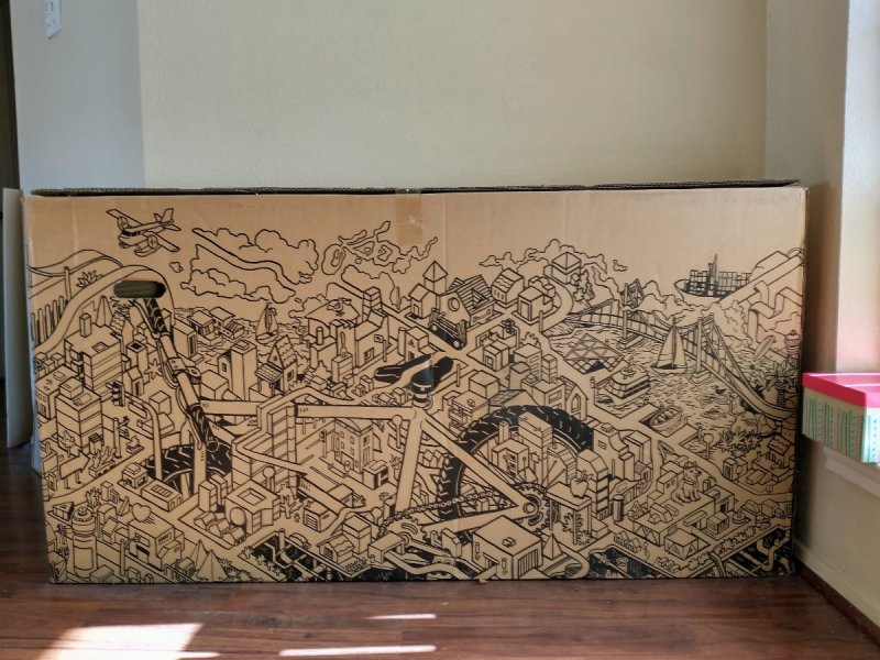
This (empty!) bike box has been sitting in my foyer for a year. The designers created something that kids (or adults) might like to color. If you have a houseful of younger kids and it's too cold for them to go outside -- nice project. Alternately, use it for its intended purpose. Otherwise it will be recycled in about two weeks (our next recycling day). In north Austin close to Walnut Creek Park. Respond below if you're interested and I'll message you the address. This is one side, there's an equally detailed but different design on the other side.
-
Some of y'all may have caught this story on the news over the last few days -- a young couple driving on the Angeles Crest Highway lost control of their car after pulling over to let an aggressive driver pass, and went tumbling down end over end 200 (some reports) to 300 (other reports) feet along a cliff to the bottom of a canyon. Zero cell service in that area. None of the media reports indicate that anyone witnessed the car going over the edge. The couple had no cell service but were rescued after their iPhone detected the fall. Amazingly, the couple only had scrapes and bruises and were able to crawl out of the car, which had landed upside down, so Miracle #1. Miracle #2 -- They were able to find the woman's cell phone about 10 yards from where the car landed, and a message had popped up on the phone, saying a crash had been detected and to swipe to contact emergency services. "...The message that appeared on the iPhone was part of Apple's new Emergency SOS via satellite feature, which has Crash Detection and Fall Detection software and uses satellites to contact emergency services when an iPhone is out of range. The feature connects the iPhone user to an emergency call center, which can collect information and notify rescue services...The message that appeared on the iPhone was part of Apple's new Emergency SOS via satellite feature, which has Crash Detection and Fall Detection software and uses satellites to contact emergency services when an iPhone is out of range. The feature connects the iPhone user to an emergency call center, which can collect information and notify rescue services." These two were rescued within 30 minutes because they could text with emergency services and rescuers were able to pinpoint their exact location. "The feature, which Fields did not even know was on the iPhone she had only recently gotten, launched in mid-November. It's currently on iPhone 14 and iPhone 14 Pro devices running iOS 16.1 or later…Emergency SOS via satellite also allows users to share their location with friends and family if they'd like to check in while traveling off the grid. It's also free for two years after an iPhone 14 is first activated, according to Apple."
-
Wonderful news, BUT a 10-ft-width just doesn't cut it for the amount of traffic these types of trails receive these days. For example, the 10-ft-width on the Southern Walnut Creek Multi-Use Path, heavily used by cyclists, is woefully inadequate. Considering the amount of lead time that goes into funding, planning/design, opening the project for bid and awarding the contract, little chance for input even for future projects. Don't get me wrong -- these paths are of huge benefit to those that use them, just wish they were a bit wider.
-
Yup, from the Austin Ridge Riders facebook page: With regret, we are rescheduling Cranksgiving to January 21, 2023. Due to the recent rain and the forecasted heavy rain for the rest of this week, the bike trails at Reimers Ranch Park are closed now and are expected to remain closed through the weekend. We felt it was better to call it sooner than later so those who were planning on attending can plan to do something else.
-
Cancelled: ARR's Cranksgiving SATURDAY, JANUARY 15
June Bug replied to June Bug's topic in Mountain Biking Discussion
This just popped up on facebook: Cranksgiving 2022 has been cancelled and rescheduled for January 21, 2023. -
The Second Sign of the Apocalypse
June Bug replied to AustinBike's topic in Mountain Biking Discussion
Forest Service and BLM have always flailed a bit where user policy is concerned, and not just related to mountain bikes, although sometimes they get it just right. Where BLM got it wrong: There's a new trail system near Mancos (about 9 miles from Dolores) called Aqueduct on a bit of BLM land, signed for mountain bikes and equestrians only. It's a well designed and purpose built trail...for bikes...but terrible for horses. A section goes into a long flow trail in an arroyo that's unrideable for equestrians. I really don't get it. It's built on the Mancos Shale formation and one or two equestrians riding on parts of the trail while it's still on the wet side would destroy it. Chicken Creek trail system (Forest Service), very close to Mancos, has maybe 20 or 30 miles of buff singletrack and two-track winding through the Ponderosas, perfectly suited to equestrians and I'm pretty sure it allows horses. A few miles further along towards Dolores? 3,000 acres of BLM land that strictly prohibits mountain bikes. Equestrians and hikers only, no defined trails. Until this past year, when a survey issue was resolved, this BLM land could not be accessed by the public. This allows public use, without much oversight on BLM's part, so equestrians, go for it! I mention these as instances as a microcosm of weird policy by Federal agencies. The Forest Service has it right on Boggy Draw and Chicken Creek, though. In winter, Boggy Draw trails are groomed for fat biking and Chicken Creek is groomed for cross country skiers. Anyway, e-bikes. I'm starting to realize that possibly the fastest segment of e-bike adopters are older cyclist, both mountain bikers and roadies. Oh, and gravel. Don't forget gravel. Also, as all-electric and hybrid cars are becoming more popular and accepted, battery technology will grow at an accelerated pace and that tech will be reflected in e-bike technology. -
The Second Sign of the Apocalypse
June Bug replied to AustinBike's topic in Mountain Biking Discussion
Forest Service. That entire trail system is actively maintained with weekly work days throughout the summer; maybe somebody brought the sign over from the trail head. I noted a few e-bikers ignoring the the ban on e-bikes in that trail system. -
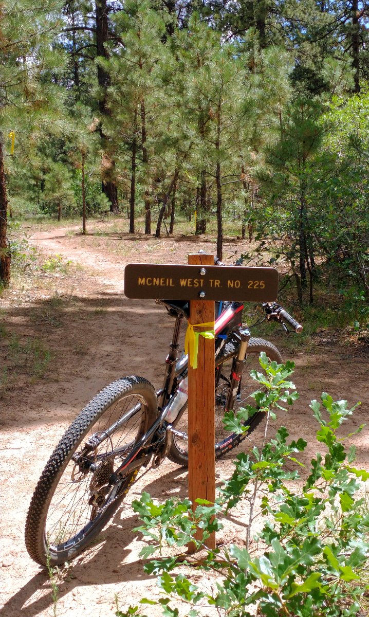
Boggy Draw Trail, (mtbproject page for Boggy Draw) extensive system of mostly buff single track though the Ponderosa pine forest: