cxagent
-
Posts
609 -
Joined
-
Last visited
-
Days Won
28
Content Type
Profiles
Forums
Gallery
Calendar
Everything posted by cxagent
-
LOVE George Carlin and especially that video. He was great at pointing out just how foolish and hypocritical we humans are. As far as the part of the trail that was closed - that was more because of the City / PARD safety concerns than erosion. The City did not like that people were riding down that "ledge" picking up speed and then crossing blind intersection where cross traffic was picking up speed to hit the Wall Ride. They felt it was just a matter of time before there was a major crash there. They wanted to close that fall line trail and not opening any alternative. The IMBA Trail Crew pointed out that creating a dead end like that would never stay closed and the problem would not go away. So they offered a better solution of the longer and more flowy trail. As far as the creek bank crashing into Walnut Creek - it has happened since probably before humans were on the earth. Look along Walnut Creek and not how deep below the 'nominal' ground surface it is. The same is found along Barton Creek. And Bull Creek. And the Colorado River. You don't have to look far to see that erosion is a natural process that has been going on since the earth's crust cooled. And to use George's example, it will go on long after humans are extinct.
-
Yes sir! We have been collecting such measurements. But with all such data - there is never enough data. Or it is in the wrong spot. Or you should have started measuring years ago. Etc. Etc. Etc. You might remember a local mtb rider by the name of Ross Martin. He was local until he earned his PhD at Texas State in 2017 before he moved away to be a university professor. His dissertation and many of the papers he wrote were about erosion, impact of bicycles vs hikers, measuring and documenting the impact, etc. He even did a 'radio type interview' with somebody like Pink Bike / MTBR / etc on the very subject. Again, he was saying the impact needs to be measured and documented so that is viewed in terms of facts as opposed to opinions.
-
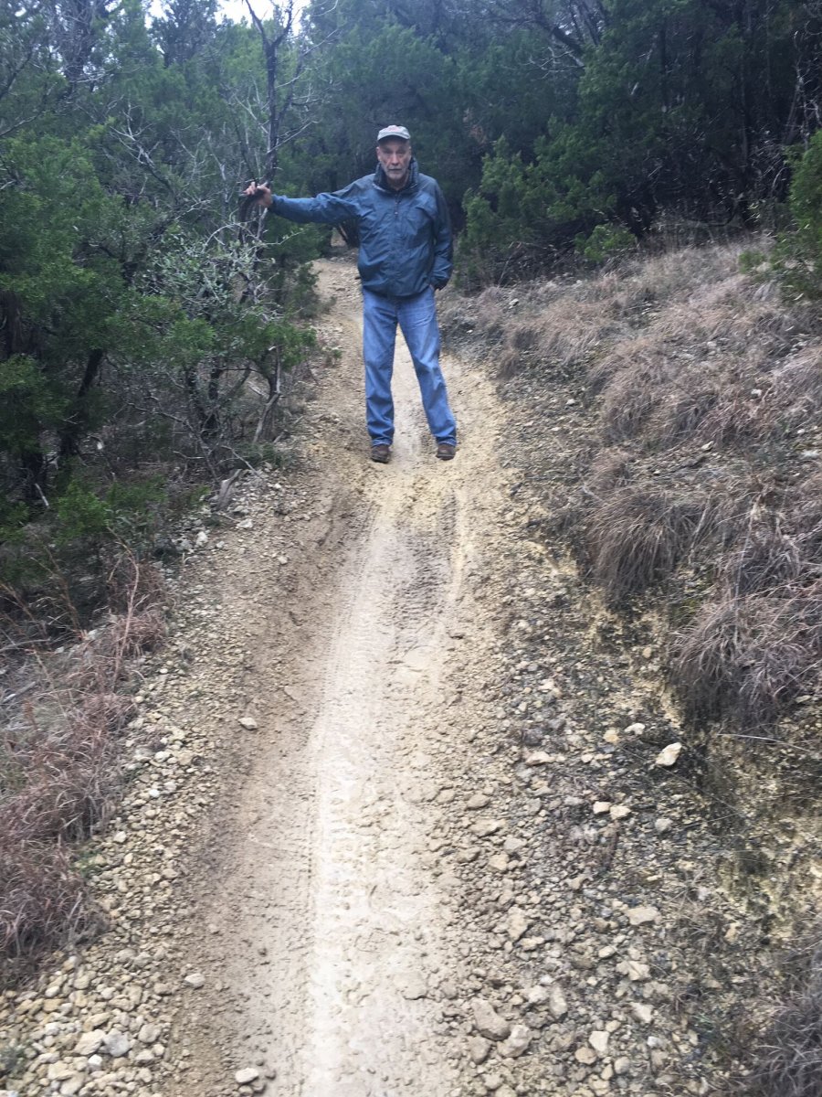
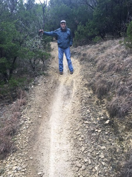
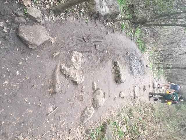
I have been trying to write something on this very topic. There are some very good posts already out there - http://www.lebanonhills.com/sustainable-trails/ The problem is that it needs to be "sound bite" for some people to pay attention and long and detailed for other people to pay attention. The same description cannot serve both. I have posted some things here before. Our soils are highly prone to damage by riding, hiking, horse back riding, etc when they are wet. Most of our soils are clay over a rocky (limestone) base. Lose the few inches of clay and the limestone is exposed. Now the stuff that holds the rocks in place is gone and the rocks start moving. You know all those loose golf ball to baseball sized rocks on most of our downhills. They used to be held in place by the black clay soil. All of our "soils" including the limestone gets soft when wet. The difficulty convincing people of that is they think "rock" is hard and never changes. Some of the limestone is like that. When you find a vertical ledge, the top layer is the hard limestone. The softer limestone that was under it has dissolved (eroded) away underneath the hard layer. There is a very illustrative spot near the start of the City Park loop that the limestone gets wet and turns to mush. We keep filling that area with small rocks to try to harden it. It works for a while. Then it gets really wet and the rocks get dug out or mashed so deep into the mush it doesn't help anymore. ETA - in the picture, you can see above the 'photo model' where the color changes. That is some of the rock we added to harden the surface. Below the model, you can see where the trail tread is once again forming a channel that focuses the water into an erosive channel flow. That channel did not exist when we filled it with rock. I will try to finish up and post at least one of my attempts to educate people about wet trails.
-
I posted to see if the person was still looking for it. If nothing pops up in a few days, I will get it and find a place to store it. I will contact you off the forum.
-
Please save it for now. There was a call for such lumber not long ago in South Austin. I'm pretty sure it will be put to good MTB use.
-
Everyone should decide for themselves what they ride and what they don't ride. That said, it is SO much easier to ride something like that when following somebody who knows the trail and rides it right in front of you. You can see their line, their moves and their pace. So you know what to do and what to expect. But I'm with you, I would chose not to ride a lot of that.
-

Williamson Creek Trail across South Austin
cxagent replied to cxagent's topic in Mountain Biking Discussion
The City just finished a project running a pipeline thru there. But that pipeline carried the stuff that came out of carbon based lifeforms. -
Williamson Creek Trail across South Austin
cxagent replied to cxagent's topic in Mountain Biking Discussion
Another person who has been working on several new trails said they think they know the real issue. These folks want to keep the area to themselves. If an official trail is allowed, then other people might use it. -
As far as offending someone - the only part I'm sorry about is that I'm not sorry about offending them. I just spent most of my weekend trying to smooth over more cases where yet another somebody is offended that they are not followed verbatim by people spending their personal time doing volunteer work. If you want a say in what gets done - spend your time doing the volunteer work that you think other volunteers are doing wrong. There were three examples this weekend alone that shows how no good deed goes unpunished. And then this morning I am walking the BCGB with City personnel and find FRESH mountain bike tracks in the mud. Yes, much of the trail is fine to ride. But the mud holes are MUD HOLES. At least ride the dry parts of the trail that were right next to the MUD HOLE. Most of the trail is just fine! ride those parts of the trail!!! I spent the whole rest of the walk trying to defend the undefendable. Like what is undefendable you ask? That mountain bikes don't damage the trail any more than hikers. Oh wait - let's go back to that MUD HOLE and see what the mountain bike tire track did. Just that one example you ask??? Oh no. Trying to defend the mountain bike tire tracks that go right past the sign that shows a mountain bike with a circle with a slash thru it. You might have seen such a sign between the first two creek crossing west of Zilker. And once again there are fresh mountain bike tire tracks thru the MUD HOLES. I would not want to cross the creek right now either. But I can at least walk my bike thru that section so I am legal. But I guess that to too much to ask for some people. Honestly folks this is getting old.
-
Williamson Creek Trail across South Austin
cxagent replied to cxagent's topic in Mountain Biking Discussion
If I remember the numbers right - the final vote was 12 to 8 against the trail. The 8 (I think) decided to send their own letter saying there were neighbors that supported the trail. This was the other end of the proposed trail from year ago and more recent events (SSV). It just amazes me how adamantly opposed some people are. I have started thinking you can hand out $100 bills to strangers and there would be some people opposed to it. The trouble is that people opposed to something write letters, sign petitions, etc. People supporting something don't seem to do much. I guess their feelings are not as strong. -
I was a Taos NM this week. I was talking to several of the ski mountain staff. They started asking if the chair lift they sold to somebody in Texas was up and running yet. Hmmm. Wonder what they were talking about??? It can be a small world if you pay attention.
-
We have been working on a new trail across south Austin to form a loop around Austin that includes south Austin. Yesterday, we met with a neighborhood that backs up to Williamson Creek. I am extremely disappointed at what many of the speakers said. Without going into great detail, the reputation of MTBr's was really really bad with this group. If I didn't know better, I would have thought they were talking about an off shoot of the Banditos motorcycle gang. I found out that we "destroy trees and creeks and kill off the wildlife". We "ride thru in huge groups with our music playing so the neighbors have to put up with that thump thump thump all night long". And "if they allow one trail, then many many more trails will pop up including trails cutting thru peoples back yards to get to the street." And "since the police can't get back there, the only way to stop them is to prevent the trail from being built at all." Never mind there is already a trail there. Absolutely nothing would change these peoples' mind. Hard data, recommendations from representative of Austin Parks Foundation, Keep Austin Beautiful, GA/VA and others were just ignored. And such reputable groups had sent representatives to the meeting to show that they DID support us and the trail, not just some yahoo saying those groups supported us and the trail. The KAB representative even handed out her cards and said she would email reports and papers to document what we were saying was true. My point in posting this is that we MTBr's absolutely must improve our reputation with the community. IMHO, every negative interaction with the public gets talked about, spread and multiplied a hundred fold. And every positive interaction only offsets one of those negative interactions with one person. Please try to be a good representative of our sport/community. Right now I'm not sure if it makes sense for me to spend time to try to improve relations with this community or to ignore them as a lost cause. If I ignore them, we may have some gaps in the official trail across south Austin.
-
Its too bad that Austin Ridge Riders have never done such a video. Oh wait - Or maybe - Or this one - But this is my favorite - Some of these videos are several years old that were "rereleased" in 2017. You might want to search YouTube for "Austin Ridge Riders". This is not all of the videos. And rumor is there may be more coming 😉
-
Urban Rides for when the trails are wet
cxagent replied to cxagent's topic in Mountain Biking Discussion
I think the way that should be said is "... *SHOULD* be closed for the month of February". But we have all seen the incredibly amazing riders that CAN ride it anyway... -
Urban Rides for when the trails are wet
cxagent replied to cxagent's topic in Mountain Biking Discussion
Albert posted this route in the Narnia thread. There are some other good posts for those interested in loops around north Austin. https://www.strava.com/activities/2110059778 One good thing about a loop is you can park anywhere along the loop. If you complete the loop - you are back to your car. -
Urban Rides for when the trails are wet
cxagent replied to cxagent's topic in Mountain Biking Discussion
Oh yeah. Strava might actually be a useful tool for these rides. Unlike other rides 😉 -
Still true today. Look at the right hand column of the legend. Note the lighter green north of Walnut Creek and the slightly darker green south of Walnut Creek. It is hard to show ALL information on the same map without the map becoming unreadable. The City did a great job trying to get the most information on to one map and keep it legible. The map in the link includes all the EMS location numbers. IMHO, those location numbers became the best way to identify a location or link together a route. So any map that did not include location numbers was not very helpful to me.
-
To the original poster - Download the PDF file from the AustinBike web site. Take that file to Kinkos, Miller Blue Print, Dynamic Reprographics, or similar print shop. Pay them to print that map in any size or configuration you desire. Say Thank You to AustinBike for fixing the problem permanently.
-
The two valid links are to very *OLD* maps. That would be before the concrete sidewalk. If you can host the file - we can fix the problem. Check your email.
-
Austinbike had the link to the PARD map that is no longer valid. We should have known that any organization bigger than AustinBike would have to fiddle with the links every so often. How else would the IT department stay busy???
-
Let's post some urban rides so people have some place to ride other than wet / muddy trails. I will start - Park at the Best Buy or Sam's Club parking lot at 290 and MOPAC. Go north on the frontage road of MOPAC to the new pedestrian bridge and follow the sidewalk to Zilker Park. Pick up Lady Bird Lake Hike and Bike Trail heading east. For a short(er) ride, loop back to the north side of the lake on any of the crossing bridges. Go south under MOPAC and reverse your route to the parking lot. (about 15 miles) For a longer ride, keep going east thru Guerrero Park until you hit the 183 bridge over the river. ( Detour to the south to get around washed out bridges Follow residential roads north to Airport and Shady Lane (not bad car traffic but not protected either). Pick up the Southern Walnut Creek Trail in Govalle Park just east of Airport and Shady Lane. Follow the big sidewalk as far as you want - Decker Lake or Manor. You will have to cross some busy roads but most of the route is protected from automobile traffic. Reverse your route when you get tired. Best Buy to Decker Lake and back is over 40 miles. I will update the mileage next time I ride it.
-
I posted a link to the City of Austin PARD map of Walnut Creek Park trails a while back. That link is now dead. I have requested a new link to the map. I will post the new link when it is available. Until then, I suggest mtbproject or ride with one of the regular group rides. But only when the trail is dry.
-
New Concrete Path across creek in Roy Guerrero park
cxagent replied to Albert's topic in Mountain Biking Discussion
There is talking about making the 3 way intersection better. But with anything related to government - don't expect anything to happen quickly. I have been hearing about improvements for at least 2 years. After someone was hit and injured at that intersection, the talking became more serious. -
Reimer's Ranch Prescribed Burn on 1/23/2019
cxagent replied to cxagent's topic in Mountain Biking Discussion
There is a major difference. Reimer's is a Travis County Park with public use as its primary purpose. Birds & such are secondary. Bull Creek and 360's primary purpose is a wildlife preserve. Any public use is secondary. At some point there will be a MAJOR fire on the BCP. Until then, "optimization for endangered species" will prevail. Never mind that such a fire would wipe out the trees the endangered warbler need to nest for decades. It is the old probability of occurrence vs impact of occurrence question. If it never occurs there is no need to mitigate for it. After it has occurred, most people wish they had done more to prevent it or reduce the impact. -
Really?!? I think of Ridenfool.