Albert
-
Posts
1,126 -
Joined
-
Last visited
-
Days Won
27
Content Type
Profiles
Forums
Gallery
Calendar
Everything posted by Albert
-
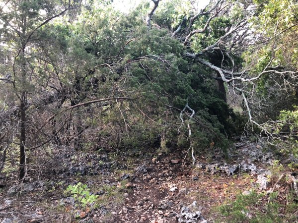
From the album: Lake Georgetown - August 26, 2018
-
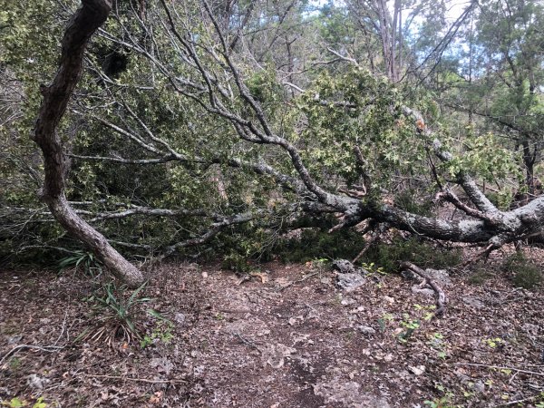
From the album: Lake Georgetown - August 26, 2018
-
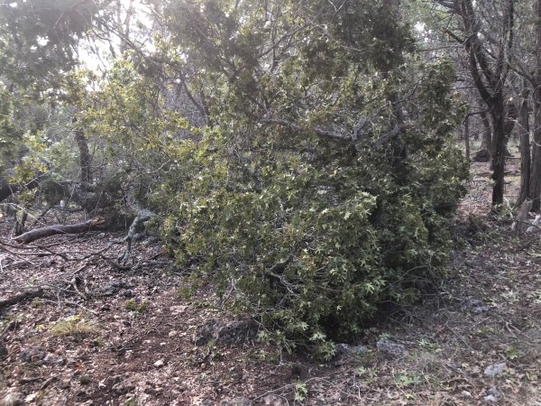
From the album: Lake Georgetown - August 26, 2018
-
From the album: Lake Georgetown - August 26, 2018
-
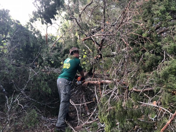
From the album: Lake Georgetown - August 26, 2018
-
From the album: Lake Georgetown - August 26, 2018
-
Thinking about losing the dropper
Albert replied to MrTheCatLady's topic in Mountain Biking Discussion
I have yet to even try a dropper post, and I've had so many people tell me what a significant difference it makes in their riding that I feel like I am missing out. Maybe I won't like it, but I feel I should at least give it a shot given all the positive reviews people have given me. So it's interesting to read your perspective about possibly ditching it! ..Al -
I'll have to compare that to one of my rides at Walnut to see how it differs. I think I see a few minor differences compared to what I normally ride, but those items probably aren't on the blue loop.
-
I'll try to join you for this upcoming Friday's ride!
-
Where did you see they changed the formula? I know they have a "Race Sealant", but I wasn't aware they changed their original formula. Have been using Stan's for years... ..Al
-
Did you end up doing the full "blue square" loop? I mentioned this in another thread, but it would be nice if the missing signs could be replaced. I'm sure they have helped many people unfamiliar with the trail. ..Al
-
No problem! I know it was short notice. Usually these things are known further out. I'll post an update when I get back home later.
-
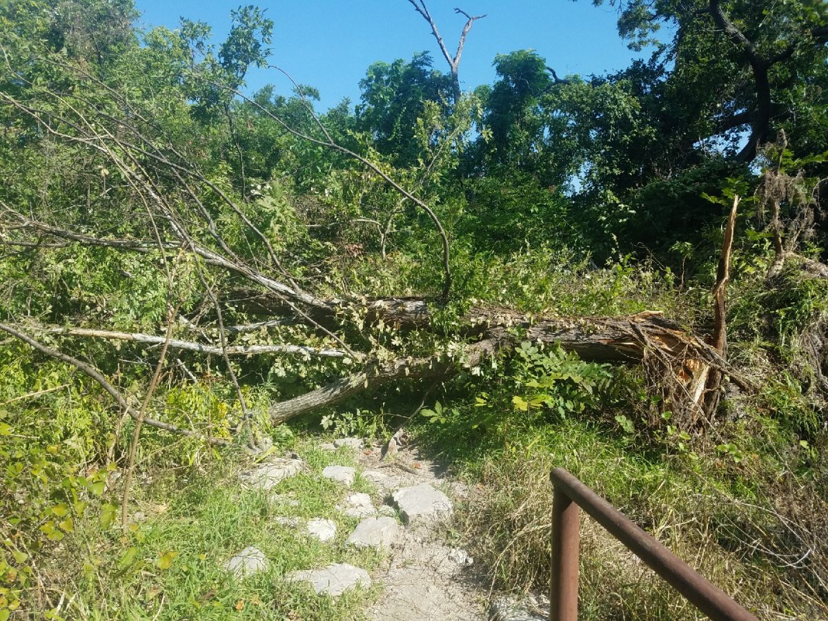
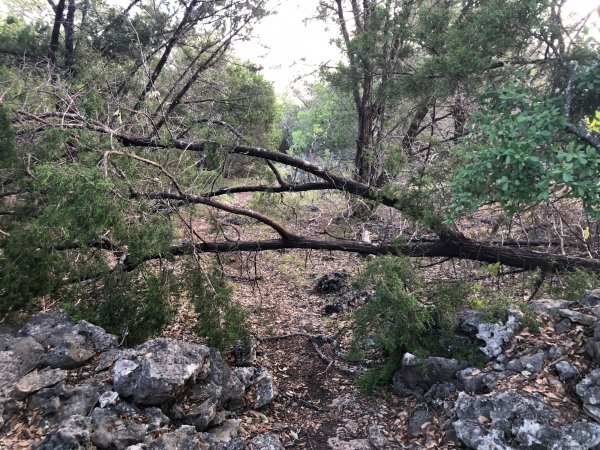
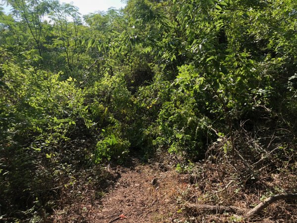
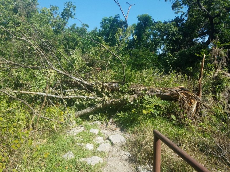
Apparently a microburst at Lake Georgetown knocked over 20 trees across the trail this week between Cedar Breaks and Cedar Hollow. Most of the damage seems to be near Crockett Springs. We're going to try and clear as much as we can tomorrow, Sunday, August 26th. We'll be meeting at 8am at Cedar Hollow, then heading east towards Crockett Springs (about 2.5 miles). We'll work for about four hours, then head back. We'll have two people authorized to use chainsaws, and then as many as possible to drag cut trees and branches off the trail. Bring at least three liters of water, gloves, heat awareness and sturdy footwear. I also recommend wearing pants. If you have a folding saw, please feel free to bring that as well to help cut smaller limbs and branches. Here is the location of the Cedar Hollow trailhead. Drive all the way to the end of W Lake Parkway and park there. If you can attend, please send me a private message so we know roughly how many to expect. This work day is TMBRA Pay Dirt eligible. Make sure to bring a Pay Dirt form and get it signed. Here's a photo of just one of the downed trees: Thank you! ..Al
-
Anybody here think the Enchilada Buffet is to easy?
Albert replied to CBaron's topic in Events / Races
If you want to catch people at cheating, make them use a GPS device (which can be a phone) that records their track and distance and take a look at it after they come across the finish line.. -
I have no idea who the admin or admins are over on MoJo, but I think it's been running on "cruise control" for some time. The forum software hasn't been updated in five years, and there are known exploits for that version of vBulletin. Spicewookie was doing a good job of cleaning up the spam from the bots, but they've become increasingly aggressive, and at one point there was a new spam post once a minute in Austin VooDoo. I know the admins cleaned up Austin VooDoo, but the rest of the forum is still plagued with spam and it doesn't look like they made any effort to delete all the spam accounts or clean up anything outside of that. I've been watching new registrations on MoJo, and the bots are still registering at the rate of around 15 a day. And I'm sure 95% of new registrations (if not more) are spambots. Just take a look at the links for each of the home icons you can see at the above link and they all go to some sketchy website. And there was another big wave of spam early this morning. I have had people ask if I can transplant threads from MoJo to this forum. While technically it would be possible (and I could certainly do it with a copy of the forum database), legally it's a sketchy area. I'd need permission from whoever owns Bike MoJo first. And many forums are setup where individual members own their comments, so in cases like that you'd really need permission from all those people to copy their comments over. Which obviously would be a huge pain in the ass. Creating an archive of Austin VooDoo would be a great idea and is something I could do, but again, I'd need a copy of the database and the blessing of Bike MoJo's owner at a minimum. I could import the entirety of Austin VooDoo into a forum here so people could continue to reference threads, and if something were to happen to Bike MoJo, at least that would be saved for posterity. If the current admins are asleep at the wheel, one of the following things is going to eventually happen: 1) The site goes away when the owner stops paying for the hosting costs, 2) The hard drive on the site crashes, taking the site with it, 3) The forum database crashes, making the site inaccessible, or 4) The site gets hacked and erased. I have no idea if active backups are being made of the site, but if not and any of the above happens, that would probably be the end of all those posts forever. I just want to have a place to talk about mountain biking on a site that is actively maintained. And if the person running the site is a local who is actively involved in mountain biking, that is certainly a plus. I want to have some fun with this site, and it's a modern platform that will give me the flexibility to add some cool features over time. I completely understand people not wanting to move to another forum, or not happy about change. Hell, anytime I make significant changes to my other forum, there are people who grouse about it for a while. Yeah, this site has a bit more "structure" than posting everything in "Austin VooDoo", but I'm ultimately hoping this site will garner more traffic, and the organization of forums will be needed. And I'm open to suggestions on how to improve the forum, so please don't hesitate to say anything if you have an idea to make something better, or there's something you don't like. I won't be offended. ..Al
-
Yeah, it'd be very difficult to complete the EB if you're not accustomed to long rides. Doing the Enchilada Buffet is no joke. The whole package requires that you be in decent enough shape to pedal for hours and hours through some of the toughest trails in Austin (BCGB, City Park, Thumper), plus the horrific road climbs connecting those trails. It's not something you're just going to hop in the saddle and succeed at if you're used to 20 mile rides at a reasonably casual pace. While some might get away with it, the rest of us need to acclimate ourselves to such feats. I agree with John, train yourself to ride longer and longer distances. Learn what kind of nutrition your body needs for these long rides. See how comfortable you are on the bike for such long periods and make any adjustments you can. Having bar ends is a good idea, on my 50 mile ride yesterday they would have been nice. I need to get some new gloves as the pads in my palms were uncomfortable after 30+ miles.
-
I'm impressed that two of those steel posts have been stolen. I think they are just bolted into the cement footer? I guess with the right tools, those might not be so hard to remove. Interesting that Hill Country Conservancy paid for the signs. Having ridden Sweet 16 yesterday, there are an asston of those signs on that section of trail. Yeah, you'll never stop the idiots, but you can make it harder for more casual destructions. ..Al
-
Thank you! Definitely good to report such things. You never know if this sort of thing is happening more than we are aware of, and with more reports that can help them possibly catch people in the act.
-
I agree the graffiti is bad, although most of the signs I saw yesterday at BCGB are fine. The closer a sign is to a trailhead, the more likely it will get vandalized, it seems. At least the signs would still be there, though, unlike the Carsonite signs that are pretty easy to remove and/or destroy. I'm sure the metal signs they installed at BCGB were pretty damn expensive.
-
What the hell is wrong with people? Maybe the City of Austin can install those larger metal posts, cemented into the ground, as they've installed all over Barton Creek Greenbelt. Those Carsonite signs are getting vandalized at Brushy Creek as well. It seems Carsonite signs are ripe for abuse on high-traffic trails.
-
If the mileage is extended much beyond 80 miles, that will certainly be a valid concern. 😄
-
I'm currently using a Garmin Edge 800 that can last through the whole thing. As long as you leave the backlight off and don't have it displaying a map page. If you're using a phone, I'd probably bring an external battery pack and have it plugged into your phone. That gets trickier if you have your phone mounted to the bike. Could always tape the battery pack to your frame. 😄
-
I use an injector tube with Stans if I'm just trying to add some sealant. It comes with a big syringe. I screw the injector into my valve, poor Stans into the syringe (and it has measurements along the side), insert the plunger and plunge away. Works pretty well and is usually less of a mess than opening up the tire! https://www.amazon.com/Stans-No-Tubes-2-Ounce-Sealant-Injector/dp/B001GSKL4A
-
There are definitely signs missing at this point. Would be nice to see them replaced.
-
What is the standard race loop? I know signs were put in at some point as a "suggested route", is that the new typical route you are describing?