Leaderboard

Popular Content
Showing content with the highest reputation on 07/25/2019 in all areas
-
Yes I have ridden Juniper Ridge. I ride it at least once per year. I think I have ridden every obstacle on the trail without dabbing at least once. Note I did not say I have no-dabbed the entire trail on the same ride. I still miss and miss a lot. You might want to know that not only have I ridden it, I also helped build it (second only to Charlie on the number of hours spent). When we are cutting trees for a new trail, we will always leave it on the 'tighter' side. Why? We can (and do) go back and take out more trees. But we cannot go put them back. So we leave the trail tighter at the beginning and open it up where we think it needs to be wider. There were also other considerations for that trail. One was keeping horses off the single track. Leaving tight tree gates and low hanging branches discourages horses. The other was ATVs. Same thing there. A group not associated with MTB followed the single track we had just cut and was widening it and smoothing it for ATVs. We chose not to build and maintain an ATV trail so it needs to be narrower. We intentionally left the next couple of tree gates passed where the ATV folks has cleared. So how do you ride a tree gate that is narrower than your handlebars? (I could not find the Dirt Bike magazine so I will describe it.) As you approach the tree gate, stand up and level your pedals once you have enough speed to coast thru. Keep your knees and elbows in line but you don't need to try to 'tuck them in'. Pick the side you will favor - usually the side that is farthest along the trail (as opposed to closest to you). Move your bike to that side of the trail so that hand will hit the tree if you tried to just ride thru. Just before that hand hits the tree, pull that hand back like you were steering a slow speed turn in that direction while keeping the bike vertical (no lean). That will effectively "stop" that hand while moving the other hand forward. Once the 'other hand' passes the tree on that side, lean the bike aggressively like you were turning in the opposite direction of the steered turn. The lean should clear the hand that was about the hit the tree. Shove that hand forward and straighten the bike up right again. Your bars are now past both trees. Hopefully, you can clear the rest of your bike between the trees. The pedal on the 'favored side' will be the next thing to work on clearing. Hopefully this word description makes sense. If I screw up this move, I end up stopped, standing on the pedals with my shoulder against one of the trees. From there I can untangle myself and ride away without dabbing. The more I practice this move the higher speed I can carry thru the trees. I suggest you start learning it my planning to ride into the tree gate and stop with your shoulder on a tree, then learn the move. Then learn to carry some speed (not stop). I hope that helps.3 points
-
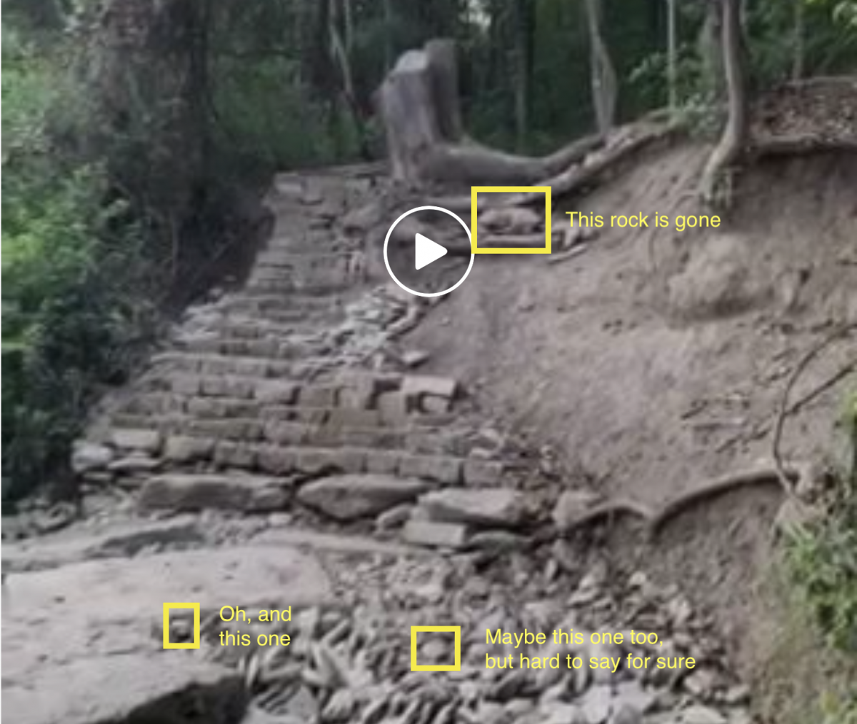
I rode it again last night. It’s an easy roll without the rock there. It seems way more sketchy with a big, loose rock in there. Sent from my iPhone using Tapatalk3 points
-
3 points
-
Not me you replied to, but an interesting take. Maybe you're just not good at bicycles?3 points
-
Here you go: -cls
 3 points
 -
Seemed downright chilly this morning.2 points
-
THE SHORT BUS - or - Winsor down connecting to Dale Ball trails After boarding the short bus in Santa Fe at the South Capital Station stop and putting a sawbuck in the slot we were off to the Ski Area where the Winsor trail head is found. I was the only rider at the first stop, and we picked up four more before departing Santa Fe for the summit. There were two local youngsters dressed in full downhill regalia, full-face helmets, padded shirts, knee, and elbow protection. The others were a couple from Reno/Tahoe area who had flown in and rented a pair of Santa Cruz bikes (similar to what they rode at home). Once at the Summit the couple (Charles and Barbara, IIRC) were the first ones on the trail as the two guys fiddled with air pressures and I added some to the rear tire too, as well as taking advantage of the last restroom I would see for many hours. The guys headed out away from the trail entrance and I figured they might be going on up to the higher section of the Winsor to begin their day. The TH is at about 10K feet and the air is very, very thin up there. I had read that the first section of trail was kinda rough, but hadn't figured in the near absence of oxygen. Rocks, roots, and OMG ... uphill sections, one after another. I was breathing very fast and still felt like I was on the verge of swooning. Several times I had to stop and wait for several minutes to accumulate an adequate amount of O2 to manage a few more steps as there was no way I would try to ride with my head spinning like that ... After some amount of time and distance I crawled out onto an area where the trail came close to the road and there was parking and signage. This was near the top, probably less than a half mile in. I found where the Winsor continued down and the trail was a lot better. After a while I came upon the two locals who I had thought had gone higher to start their ride. This was confusing for a moment. They were stopped in the trail fiddling with more settings, air pressure, and I was scratching my head about how they got in front of me. We talked and they revealed that nobody who knows better ever rides that section I had just done, and they had coasted down the road to the next trail head to avoid all that crap. Very Important Note (VIN) 1 - Do NOT start this ride at the top. Skip the rocky, chunky, rooty bits and give your body a break from trying to wrestle with attempting full functionality without O2 in adequate quantities to sustain the efforts required to get through this section. Unless you just want to experience that rush of asphyxiation. (ala David Carradine) I got around the locals and headed on down. The trail smoothed out and was a joy to ride in comparison to that upper bit. Next was a split in the trail, to the right was labeled "Technical Trail" and to the left was plain-ole Winsor. While I was pondering my choices the guys rolled up said hi again (they were very polite and good natured fellows) and took the right. I took the left. This was the last I saw of those guys, and I'm pretty sure they remained behind me as I heard them whooping and hollering when I passed the point that technical trail rejoined the Winsor. The Winsor is an absolute blast. The section I rode was nine miles of mostly gravity induced grins. Eventually I caught up to Barbara and she heard me and made room, then a few minutes later I rolled up on Charles waiting for her. We compared trail plans and it seemed that they were essentially doing what I had mapped out and we rode together for the balance of the Winsor section. They were my age (well past a half century), and Charles was a very good rider. I stayed close, but wasn't wiling to push it like he was, mostly because I was being cautious and slowing for the potential of hikers or an uphill rider (actually encountered one rider going up) being around the next bend where I couldn't see. We slinkied on down pausing for Barbara a few times, and started looking for where we needed to bail in order to head toward Santa Fe, rather than toward Tesuque where the Winsor finally ends. It got tricky, and Charles had been warned by the folks at Mellow Velo, where they rented, that the trail we wanted was Carol, and not to get on Burn or take Carol to Burn, and that finding Carol could be confusing. Well, it was. Even TrailForks with GPS didn't seem to show me being at a point where there was trail to the right when we came to a Y with no signage. The GPS showed we had completely missed seeing Burn, flying past it on the downhill, but also weren't to Carol yet. Charles scouted the trail to the left while Barb and I took a moment to have a bite and sip some water. He rolled back to a spot nearby and reported it seemed most likely the trail we wanted. "Wanted" being a bit of a euphemism, as sweet little Carol led us on a climb of 466 ft over the next mile. I did meet a hiker wearing a Specialized cap walking down and commented how it may have been a mistake for me to bring a bicycle along on such a nice hiking trail ... the first of several such climbs in my future. After my hike-a-bike on Carol the descent began. Though it seemed like a mirage or, perhaps a lucid dream after that climb. I've always wanted to experience lucid dreaming and just rolled with it, enjoying the front wheel being on the low end of the trail for a change and some wind to make the magic in the Omni-Zero fabric perform magnificently. I never saw Charles and Barbara again. She had been leaning toward convincing Charles to head out to Hyde Park Road by taking the left on Little Tesuque Creek trail at the end of Carol. She wanted to take pavement back to Santa Fe after I had described the elevation for both Carol and the next trail and I'm suspecting that is what they did. Smart folks they are. A quick glance at the computer and I realize how the halfway point for the expected mileage today has now been attained. It is at this time I will take a moment and make note of one aspect of the ride that proved to be a disappointment. The outdoor air conditioning had apparently been turned off, and where I had been expecting highs in the low 80s, I was seeing the temp on the bike computer now ranging up into the 90s and as high as 109 in places as I crawled up Carol, pushing the bike along my hike on many sections. I got to the T and briefly pondered taking the left to easy salvation, then, chose to take the right. Stick with the plan I said, as it included riding some of the Dale Ball trails. I've brought 4.5 liters of water with me I said. Columbia's shirt had magical properties that were doing a great job of heat management I reasoned. (if reason is what that can be called, still, it added to the justification to press on, regardless) Besides, I've never been keen about riding a bicycle on busy, narrow mountain roads. To the right it was, onto Little Tesuque that takes the rider foolish enough to go this way directly to the La Piedra Connector. More about that in a moment. Little Tesuque trail follows the creek into an environment that was full of lush water-fed grasses. A microcosm in the otherwise high desert surroundings. It was quite lovely, lulling me into a false sense of serenity and calm as I found a nice spot to stop and have a bite, down a fizzy tablet of electrolyte goodness, letting it disincorporate into mouth fulls of water while I bided my time enjoying this cool, breezy, shady respite. Little did I know the onerous task, ney, torture, waiting for me unseen a mere 50 feet away. In Spanish the translation for La Piedra is "the rock" or "the stone" and that is sweet and all, but in the local Santa Fean dialect the translation is more like. "The god-awful chunk of rock that some sadistic bastard of a trail builder carved upon to test the will and very soul of anyone attempting to use La Piedra to connect a pleasant Winsor downhill ride with the Dale Ball trails. This jewel in the cap of Marquis de Sade's crown gains 674 feet over 1 mile of trail that includes a series of ~30 switchbacks with rarely more than 50 feet of very steep trail between turns. There is no riding up unless you have the skills of Hans 'NoWay' Rey or Danny Macskill. Walking up with a bike takes time. On the way I see temps steadily over 100, and was thankful that there were plenty of trees offering shady spots every twenty feet or so to stop, sip water, and trudge onward. VIN2 - DO NOT UNDER ANY CIRCUMSTANCES TRY TO CONNECT A WINSOR DOWNHILL RIDE WITH DALE BALL TRAILS just go on down to Tesuque and catch the bus back to Sante Fe. Really... I mean it... especially in July. I never actually thought I was going to die, but in retrospect I may have just been telling myself that as a way to ease my passing from this mortal coil should it come to that. As near as I can tell by signage and a remarkably stout cedar pole fence toward the top, this connector trail had to be built in a very narrow section between private property lines on either side. There is no other reason for it to have been built this way. Ah, here's a blog post on the construction of the trail. As I'm ascending this marvel of modern trail building I'm hearing the thunder of afternoon storms brewing over the mountain I came down. Big rolling, crackling noises, lightning zip-zapping between clouds, it becomes obvious to me how I'm now headed to the peak in order to offer optimal exposure for a rider seeking to become a high point should electricity be coursing through the nearby air seeking a convenient path to connect to the electrons anxiously awaiting the trip skyward from terra firma. Rolling spritely over the peak I gratefully descend on steep, yet rideable trail leading me to another Y. After study upon the choices on TrailForks elevation profile, I take the lesser climb on the right spur to begin another set of switchbacks that eventually get me the hell off of La Piedra trail. I have attained the goal. I am on the famous Dale Ball trails! Yay. VIN3 - Dale Ball trails aren't named, instead, the intersections and waypoints are numbered. This was quite confusing as the trails are described as "Dale Ball #2-#3" and such. Fortunately, they are well signed and once I became used to looking for the direction to the next marker, rather than thinking of them as trail numbers it became a breeze to navigate. The Dall Ball trails I rode were flowy fun, with an occasional climb. As an added bonus the winds being sucked into the base of the CumuloNimbus making noises nearby brought the temps down to the 80s and made the Dale Ball riding that much better. Here is the order of precedence for the Dale Ball trail markers as ridden post-La Piedra: 2, 3, 4, 5, 10, 11 ... At which point I'd like to mention how the trail crosses Hyde Park Road (NM475) between 10 and 11. When I got there I checked my watch. 1500 hours. I knew the last shuttle bus was just leaving the summit and I could wait here for 30 minutes and flag it down for a ride back to within a half mile of the house. I deliberated, I hemmed, I hawed, I applied all I know about survival in the wild ... In the spirit of all my previous decisions along this ride, I took into serious consideration factors such as fatigue, the heat, the dwindling water supply and, as you have come to expect by now, I crossed the road and entered the singletrack, away from the safety and convenience of the returning Short Bus, taking the trail that led, unremarkably, to yet another set of upwardly immobile switchbacks. Bus, schmuss. I don't need no stinkin' bus. I'm quite literally cranking it up, ... to 11, as it were. From there it was on to markers 12, 18, 20 and 24 which is an OMG FUN downhill to Cerro Gordo road. A guy at Bike N Sport had told me the locals will take a left on the pavement and ride uphill a little ways to Upper Canyon Road, then take it back into town because it is mostly downhill and has less traffic. Which is what I did. VIN4 - Do what the locals do and take Upper Canyon. Coasting, I was very nearly exceeding the posted speed limit of 20mph for much of the way. Final tally, Roughly 6 hours 23.11 miles from the peak to the VRBO 6317 ft descending (TrailForks) 3097 ft ascending (TrailForks) If an ol' fart like me can do this solo, you might be able to as well ... ... just don't cuss me, cuz I done told you it wasn't a very good idea.2 points
-
That's not too far from what one shop owner/rider mentioned to me in frustration with the manufacturer maintenance intervals. FWIW, I should have mentioned I put 10k+ miles on my Talas before I had to replace the CSU. I never used the full bottle of shock oil I bought. I doubt I serviced it 10 times. If I'd wiped things down I might have never had to have the CSU replaced. That's why I think just changing the lowers oil every 200-250 miles or so and rinsing the foam rings is fine.2 points
-
Columbia Omni-Freeze Zero update. I've worn these shirts now in humid CenTex while chain sawing and stacking wood in 90-100 degrees and high humidity, where the shirt moved the sweat away quickly and didn't saturate, cling, or drip. Compared with the day before, wearing another Columbia button up wicking shirt that just held sweat. Now, further testing by the Ridenfool Institute of General Foolishness has been conducted in arid New Mexico where the cooling effect has been most noticeable while riding in the high desert where it made an aggressive day ride much more comfortable than it otherwise would have been. I'm hooked on these in long sleeves for Summer wear providing shade and relief from sweat build up. For more detail on the official Santa Fe test ride, click here.1 point
-
That wasn't me at my most polite, no. But it was meant more snarky/tongue-in-cheek than downright insulting.1 point
-
Work and other obligations have been tough this week. I got a good morning ride in on Monday, but I'm not dickin around tomorrow after today's cool temps. Biking comes first. Forecast is 70 at 8am. I'll take it!1 point
-
This type a talk is frowned upon in these here parts boy. Best you get used to them tree gates or else we will have sic Bartman on you.1 point
-
Pedernales is one of my favorite local trails! It is certainly one of the best trail systems in a Texas State Park, the best I've seen although I haven't ridden a few well known parks in the state. Juniper Ridge may not have a lot of climbing but a full loop out there has a decent amount of climbing and sustained effort from traversing oodles of rock gardens. I'm usually pretty beat after 18-20 miles. Tree gates are a contentious debate but I do think everything out there is doable with wide bars (780mm) with some body english and technique. There's no need to insult someone that doesn't like a certain feature type, amirite? That said, the trail is what it is, so it is best to appreciate it that way and learn to deal with the sticky spots.1 point
-
Not for nothing there are more "entry points" just go the right direction. Example.. enter at the concrete sidewalk by BC road and just go left .. same correct direction Sent from my SM-N960U using Tapatalk1 point
-
YES! Trimmed up nice. And finally well marked with Blue flagging. (Still can be better marked) but yes night and day different from when it was a jungle. Sent from my SM-N960U using Tapatalk1 point
-
woah woah woah! huge apples to oranges comparison youre making there. I dont have a problem with e-bikes either, but dont compare suspension and a dropper post to adding a motor to a bicycle. one of the biggest pride points about riding bicycles is that youre completely driven and propelled by your own generated human power. all that distance you just covered, or that huge mountain you just ascended - all done with your heart, lungs, and muscles. not a motor. you can add all the shocks and droppers and fancy bling components to your bike and its still a bicycle. but the moment you add a motor for propulsion its not longer a bicycle, its a motorized vehicle. the end if you crank up the far west blvd hill on a bike next to a guy riding an e-bike and you both set strava PRs at the top, the achievements arent the same. that being said I totally promote ebikes for people that arent able bodied, but if you are able bodied, you loose some points there1 point
-
Is it trimmed all the way in that big, open area going north before you get to the trees? That sure would be nice. Needed some trimming beyond that as well, but haven't ridden it in a month, so no idea what it looks like now! ..Al1 point
-
1 point
-
Last Friday evening was too hot. The heat index was well above 100 degrees. I did some building at the entrance to Peddlers Pass (improving sightlines for those entering and exiting the trail). I was there longer than expected (3 hours). After 2.5 hours I started to see the 1st signs of heat exhaustion, no energy and a little nauseous. At 3 hours I recognized I better stop before it got worse. That night I threw up several times and felt like S!@#. I drank plenty of water and was working in the shade. I was really surprised at how quickly the symptoms started. Normally, my early warning symptom is a slight headache, when get that I stop. This time, no headache, straight to throwing up. Make sure you educate yourself on the symptoms.1 point